- Milwaukee County, Wisconsin
-
Milwaukee County, Wisconsin 
Seal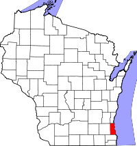
Location in the state of Wisconsin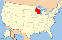
Wisconsin's location in the U.S.Founded 1834 Seat Milwaukee Area
- Total
- Land
- Water
1,190 sq mi (3,082 km²)
242 sq mi (627 km²)
948 sq mi (2,455 km²), 79.70%Population
- (2010)
- Density
947,735
3,929/sq mi (1,517/km²)Website www.county.milwaukee.gov Milwaukee County is a county in the U.S. state of Wisconsin. As of the 2010 census, the county had a population of 947,735. Its county seat is Milwaukee.[1]
Contents
Geography
According to the U.S. Census Bureau, the county has a total area of 1,190 square miles (3,081 km²), of which 242 square miles (626 km²) is land and 948 square miles (2,456 km²) (79.70%) is water.[2]
Major highways
 Interstate 94
 Interstate 43
 Interstate 794
 Interstate 894
 U.S. Highway 18
 U.S. Highway 41
 U.S. Highway 45
 Highway 24 (Wisconsin)
 Highway 32 (Wisconsin)
 Highway 36 (Wisconsin)
 Highway 38 (Wisconsin)
 Highway 57 (Wisconsin)
 Highway 59 (Wisconsin)
 Highway 100 (Wisconsin)
 Highway 119 (Wisconsin)
 Highway 145 (Wisconsin)
 Highway 175 (Wisconsin)
 Highway 181 (Wisconsin)
 Highway 190 (Wisconsin)
 Highway 241 (Wisconsin)
 Highway 794 (Wisconsin)
Adjacent counties
- Ozaukee County - north
- Racine County - south
- Waukesha County - west
- Washington County - northwest
- Muskegon County, Michigan - east (maritime border)
- Ottawa County, Michigan - east (maritime border)
Demographics
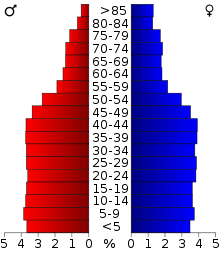 2000 Census Age Pyramid for Milwaukee County.
Historical populations Census Pop. %± 1850 31,077 — 1860 62,518 101.2% 1870 89,930 43.8% 1880 138,537 54.0% 1890 236,101 70.4% 1900 330,017 39.8% 1910 433,187 31.3% 1920 539,449 24.5% 1930 725,263 34.4% 1940 766,885 5.7% 1950 871,047 13.6% 1960 1,036,041 18.9% 1970 1,054,063 1.7% 1980 964,988 −8.5% 1990 959,275 −0.6% 2000 940,164 −2.0% 2010 947,735 0.8% Source: U.S. Census[3] As of the 2000 census, the county had a population of 940,164.[4] Its estimated 2008 population was 953,328.[5] As of the 2007 census[4] estimate, there were 951,026 people, 377,729 households, and 225,126 families residing in the county. The population density was 3,931 people per square mile (1,503/km²). There were 400,093 housing units at an average density of 1,656 per square mile (640/km²). The racial makeup of the county was 65.62% White, 24.59% Black or African American, 0.72% Native American, 2.57% Asian, 0.04% Pacific Islander, 4.25% from other races, and 2.21% from two or more races. 8.77% of the population were Hispanic or Latino of any race. 25.0% were of German, 10.9% Polish and 5.3% Irish ancestry according to Census 2000.
There were 377,729 households out of which 29.50% had children under the age of 18 living with them, 39.00% were married couples living together, 16.30% had a female householder with no husband present, and 40.40% were non-families. 33.00% of all households were made up of individuals and 10.70% had someone living alone who was 65 years of age or older. The average household size was 2.43 and the average family size was 3.13.
In the county, the population was spread out with 26.40% under the age of 18, 10.50% from 18 to 24, 30.30% from 25 to 44, 20.00% from 45 to 64, and 12.90% who were 65 years of age or older. The median age was 34 years. For every 100 females there were 92.00 males. For every 100 females age 18 and over, there were 88.10 males.
In 2000, the county was the center of the Metropolitan Area in which the residential pattern of Blacks versus Whites was the most extremely segregated in the country, according to the U.S. Census Bureau.[6]
Government
- County Executive: Chris Abele (D)
- District Attorney: John T. Chisholm (D)
- Sheriff: David A. Clark. (D)
- Register of Deeds: John La Fave (D)
- Board of Supervisors (19 members) [1]
Transportation
Bus service in Milwaukee County is provided by the Milwaukee County Transit System, which operates 469 New Flyer and 5 Gillig Low Floor buses on 56 routes. The transit system received an additional nine buses in 2006.
Cities and villages
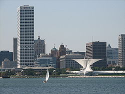 Milwaukee, Wisconsin's largest city
- Bayside
- Brown Deer
- Cudahy
- Fox Point
- Franklin
- Glendale
- Greendale
- Greenfield
- Hales Corners
- Milwaukee
- Oak Creek
- River Hills
- Shorewood
- South Milwaukee
- St. Francis
- Wauwatosa
- West Allis
- West Milwaukee
- Whitefish Bay
See also
References
- ^ "Find a County". National Association of Counties. http://www.naco.org/Counties/Pages/FindACounty.aspx. Retrieved 2011-06-07.
- ^ U.S. Census Bureau. Census 2000 U.S. Gazetteer Files
- ^ Southeastern Wisconsin Regional Planning Commission (July 2004) (PDF). The Population of Southeastern Wisconsin. Technical Report Number 11 (4th Edition). http://www.sewrpc.org/SEWRPCFiles/Publications/TechRep/tr-011_population_southeastern_wisconsin.pdf. Retrieved 2007-04-09.
- ^ a b "American FactFinder". United States Census Bureau. http://factfinder.census.gov. Retrieved 2008-01-31.
- ^ http://factfinder.census.gov/servlet/GCTTable?_bm=y&-geo_id=04000US55&-_box_head_nbr=GCT-T1-R&-ds_name=PEP_2008_EST&-_lang=en&-redoLog=false&-mt_name=PEP_2008_EST_GCTT1_ST2&-format=ST-2S&-_sse=on
- ^ Racial and Ethnic Residential Segregation in the United States: 1980-2000
External links

Washington County Ozaukee County Muskegon County, Michigan Waukesha County 
Ottawa County, Michigan  Milwaukee County, Wisconsin

Racine County Milwaukee Metropolitan Area Central City 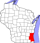
Largest Municipalities
(over 25,000 in 2000)BrookfieldC · FranklinC · GreenfieldC · Menomonee FallsV · New BerlinC · Oak CreekC · RacineC · WaukeshaC · WauwatosaC · West AllisC · West BendC
Municipalities
(over 10,000 in 2000)Brown DeerV · CaledoniaV · CedarburgC · CudahyC · GermantownV · GlendaleC · GraftonV · GreendaleV · MequonC · MuskegoC · OconomowocC · PewaukeeC · RichfieldT · ShorewoodV · South MilwaukeeC · Whitefish BayV
Smaller Municipalities
(under 10,000 in 2000)BaysideV · Big BendV · BrookfieldT · Elm GroveV · Fox PointV · HartlandV · Hales CornersV · MukwonagoV · PewaukeeV · River HillsV · SaukvilleV · Saint FrancisC · SussexV · ThiensvilleV · West MilwaukeeV
Counties Milwaukee · Ozaukee · Racine · Washington · Waukesha
Notes: Vvillage Ttown Ccity Municipalities and communities of Milwaukee County, Wisconsin County seat: Milwaukee Cities Cudahy | Franklin | Glendale | Greenfield | Milwaukee | Oak Creek | South Milwaukee | St. Francis | Wauwatosa | West Allis

Villages Bayside‡ | Brown Deer | Fox Point | Greendale | Hales Corners | River Hills | Shorewood | West Milwaukee | Whitefish Bay
Footnotes ‡This populated place also has portions in an adjacent county or counties
Categories:- Wisconsin counties
- Milwaukee County, Wisconsin
- 1834 establishments in the United States
- Populated places established in 1834


Wikimedia Foundation. 2010.