- Dane County, Wisconsin
-
Dane County, Wisconsin 
Seal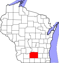
Location in the state of Wisconsin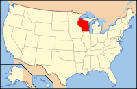
Wisconsin's location in the U.S.Founded 1839 Seat Madison Largest city Madison Area
- Total
- Land
- Water
1,238 sq mi (3,206 km²)
1,202 sq mi (3,113 km²)
36 sq mi (93 km²), 2.94%Population
- (2010)
- Density
488,073
355/sq mi (137/km²)Website www.co.dane.wi.us Dane County is a county in the U.S. state of Wisconsin. Its population was 488,073 at the 2010 census. The county seat is Madison, which is also the capital of the state. The U.S. Census Bureau's Madison Metropolitan Statistical Area includes all of Dane County (as well as neighboring Iowa and Columbia counties). Dane County is made up of more than 60 cities, towns, and villages.
Dane County is the second most populous county in Wisconsin behind Milwaukee County.[1]
Contents
History
Dane County was formed in 1836 as a territorial county. It was named after Nathan Dane, a Massachusetts delegate to the Congress of the Confederation who helped carve Wisconsin out of the Northwest Territory.[2]
Demographics
 2000 Census Age Pyramid for Dane County.
Historical populations Census Pop. %± 1900 69,435 — 1910 77,435 11.5% 1920 89,432 15.5% 1930 112,737 26.1% 1940 130,660 15.9% 1950 169,357 29.6% 1960 222,095 31.1% 1970 290,272 30.7% 1980 323,545 11.5% 1990 367,085 13.5% 2000 426,526 16.2% 2010 488,073 14.4% Source: U.S. Census[3] As of the census[4] of 2000, there were 426,526 people, 173,484 households, and 100,794 families residing in the county. The population density was 355 people per square mile (137/km²). There were 180,398 housing units at an average density of 150 per square mile (58/km²). The racial makeup of the county was 88.96% White, 4.00% Black or African American, 0.33% Native American, 3.45% Asian, 0.03% Pacific Islander, 1.43% from other races, and 1.79% from two or more races. 3.37% of the population were Hispanic or Latino of any race. 34.4% were of German, 11.5% Norwegian, 8.9% Irish and 6.0% English ancestry according to Census 2000.
There were 173,484 households out of which 29.00% had children under the age of 18 living with them, 47.10% were married couples living together, 7.90% had a female householder with no husband present, and 41.90% were non-families. 29.40% of all households were made up of individuals and 7.00% had someone living alone who was 65 years of age or older. The average household size was 2.37 and the average family size was 2.97.
In the county, the population was spread out with 22.60% under the age of 18, 14.30% from 18 to 24, 32.50% from 25 to 44, 21.30% from 45 to 64, and 9.30% who were 65 years of age or older. The median age was 33 years. For every 100 females there were 97.90 males. For every 100 females age 18 and over, there were 96.00 males.
Government
Dane County is governed by a county executive and a county legislature. The county legislature known as the Board of Supervisors consists of 37 members each elected from single member districts. The county executive is elected in a countywide vote.
County executives of Dane County, Wisconsin
The list of county executives of Dane County, Wisconsin. The list may not be complete.[5]
- Jonathan B. Barry
- Richard J. Phelps
- Kathleen Falk
- Joe Parisi
Geography
According to the U.S. Census Bureau, the county has a total area of 1,238 square miles (3,206.4 km2), of which 1,202 square miles (3,113.2 km2) is land and 36 square miles (93.2 km2) (2.94%) is water.
Major highways
 Interstate 39
 Interstate 90
 Interstate 94
 U.S. Highway 12
 U.S. Highway 14
 U.S. Highway 18
 U.S. Highway 51
 U.S. Highway 151
 Highway 19 (Wisconsin)
 Highway 30 (Wisconsin)
 Highway 69 (Wisconsin)
 Highway 73 (Wisconsin)
 Highway 78 (Wisconsin)
 Highway 89 (Wisconsin)
 Highway 92 (Wisconsin)
 Highway 104 (Wisconsin)
 Highway 106 (Wisconsin)
 Highway 113 (Wisconsin)
 Highway 134 (Wisconsin)
 Highway 138 (Wisconsin)
 Highway 188 (Wisconsin)
Adjacent counties
- Columbia County - north
- Dodge County - northeast
- Jefferson County - east
- Rock County - southeast
- Green County - south
- Iowa County - west
- Sauk County - northwest
Cities, villages and towns
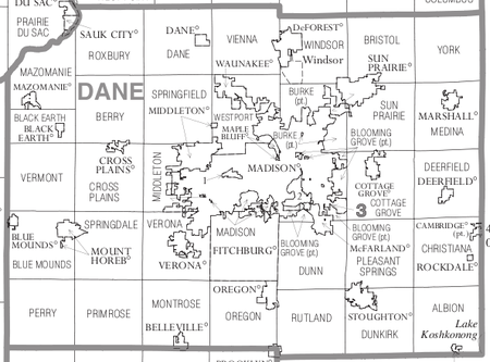
Dane County Cities
Dane County Villages
Dane County Towns- Albion
- Berry
- Black Earth
- Blooming Grove
- Blue Mounds
- Bristol
- Burke
- Christiana
- Cottage Grove
- Cross Plains
- Dane
- Deerfield
- Dunkirk
- Dunn
- Madison
- Mazomanie
- Medina
- Middleton
- Montrose
- Oregon
- Perry
- Pleasant Springs
- Primrose
- Roxbury
- Rutland
- Springdale
- Springfield
- Sun Prairie
- Vermont
- Verona
- Vienna
- Westport
- Windsor
- York
Census-designated places
- Windsor (CDP)
Unincorporated communities
 Wisconsin State Capitol in Dane County
- Albion
- Ashton
- Ashton Corners
- Basco
- Daleyville
- Deansville
- Door Creek
- Dunkirk
- East Bristol
- Five Points
- Forward
- Hanerville
- Hillside
- Hope
- Kegonsa
- Klevenville
- Lake Windsor
- London (partial)
- Martinsville
- Marxville
- Middleton Junction
- Montrose
- Morrisonville
- Mt. Vernon
- Nora
- North Bristol
- Norway Grove
- Paoli
- Pierceville
- Pine Bluff
- Primrose
- Riley
- Roxbury
- Rutland
- Springfield Corners
- Token Creek
- Utica
- Vilas
- West Middleton
- York Center
See also
References
- ^ Transport 2020 | Study Information
- ^ Wisconsin Local History and Biography Articles
- ^ Gibson. "PEstimates of Population Change for Metropolitan Statistical Areas and Rankings: July 1, 2008 to July 1, 2009 (CBSA-EST2009-05)". http://www.census.gov/popest/metro/CBSA-est2009-pop-chg.html.
- ^ "American FactFinder". United States Census Bureau. http://factfinder.census.gov. Retrieved 2008-01-31.
- ^ Our Campaigns, County Executives of Dane County
Further reading
- Durrie, Daniel S. A History of Madison, the Capital of Wisconsin; including the Four lake country. Madison: Atwood & Culver, 1874.
- Madison, Dane County and Surrounding Towns. Madison: W. J. Park, 1877.
- Biographical Review of Dane County, Wisconsin. Chicago: Biographical Review Publishing Company, 1893.
External links

Sauk County Columbia County Dodge County Iowa County 
Jefferson County  Dane County, Wisconsin

Green County Rock County Madison Metropolitan Area Surrounding
communities(over 10,000) (under 10,000) Arena | Arlington | Ashton Corners* | Blooming Grove* | Barneveld | Bristol* | Burke* | Columbus | Cottage Grove‡ | De Forest‡ | Dunkirk* | Dodgeville | Dunn* | Hope* | Lodi‡ | Lake Wisconsin, Wisconsin§ | Maple Bluff‡ | McFarland‡ | Mt Horeb‡ | Monona° | Montrose* | Oregon‡ | Pardeville | Pleasant Springs | Portage° | Poynette | Ridgeway | Shorewood Hills‡ | Springfield* | Town of Madison* | Verona° | | Westport* | Wisconsin Dells° | Windsor* | Wyocena*
Counties *town ‡village °city §CDP  State of Wisconsin
Madison (capital) Topics History · Governors · Delegations · Sports · People · Geography · Demographics · Economy · Visitor Attractions
Regions Major metropolitan areas
(pop. over 500,000)Chicago metropolitan area · Madison metropolitan area · Milwaukee metropolitan area · Twin Cities metropolitan area
Largest cities
(pop. over 50,000)Appleton · Eau Claire · Green Bay · Janesville · Kenosha · La Crosse · Madison · Milwaukee · Oshkosh · Racine · Waukesha · West Allis
Smaller cities
(pop. 15,000 to 50,000)Beaver Dam · Beloit · Brookfield · Cudahy · De Pere · Fitchburg · Fond du Lac · Franklin · Greenfield · Manitowoc · Marshfield · Menasha · Mequon · Middleton · Muskego · Neenah · New Berlin · Oak Creek · Onalaska · Sheboygan · South Milwaukee · Stevens Point · Sun Prairie · Superior · Watertown · Wausau · Wauwatosa · West Bend · Wisconsin Rapids
Largest villages
(pop. over 15,000)Counties Adams · Ashland · Barron · Bayfield · Brown · Buffalo · Burnett · Calumet · Chippewa · Clark · Columbia · Crawford · Dane · Dodge · Door · Douglas · Dunn · Eau Claire · Florence · Fond du Lac · Forest · Grant · Green · Green Lake · Iowa · Iron · Jackson · Jefferson · Juneau · Kenosha · Kewaunee · La Crosse · Lafayette · Langlade · Lincoln · Manitowoc · Marathon · Marinette · Marquette · Menominee · Milwaukee · Monroe · Oconto · Oneida · Outagamie · Ozaukee · Pepin · Pierce · Polk · Portage · Price · Racine · Richland · Rock · Rusk · Sauk · Sawyer · Shawano · Sheboygan · St. Croix · Taylor · Trempealeau · Vernon · Vilas · Walworth · Washburn · Washington · Waukesha · Waupaca · Waushara · Winnebago · Wood
Categories:- Wisconsin counties
- Dane County, Wisconsin
- 1839 establishments in the United States
- Populated places established in 1839
- Madison metropolitan area


Wikimedia Foundation. 2010.