- Marathon County, Wisconsin
-
Marathon County, Wisconsin 
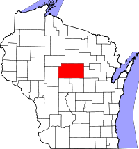
Location in the state of Wisconsin
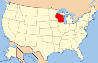
Wisconsin's location in the U.S.Founded 1807 Seat Wausau Area
- Total
- Land
- Water
1,576 sq mi (4,082 km²)
1,545 sq mi (4,002 km²)
31 sq mi (80 km²), 1.98%Population
- (2010)
- Density
134,063
80/sq mi (31/km²)Website www.co.marathon.wi.us Marathon County is a county located in the U.S. state of Wisconsin. It is part of the Wausau, WI, Metropolitan Statistical Area. As of 2010, the population was 134,063.[1] Its county seat is Wausau.[2]
Contents
Geography
According to the U.S. Census Bureau, the county has a total area of 1,576 square miles (4,080 km2), of which 1,545 square miles (4,000 km2) are land and 31 square miles (80 km2) (1.98%) are water. Marathon County is the largest county in Wisconsin by land area.
Major highways
 U.S. Route 51
 Interstate 39
 Highway 13 (Wisconsin)
 Highway 29 (Wisconsin)
 Highway 49 (Wisconsin)
 Highway 52 (Wisconsin)
Adjacent counties
- Lincoln County - north
- Langlade County - northeast
- Shawano County - east
- Waupaca County - southeast
- Portage County - south
- Wood County - south
- Clark County - west
- Taylor County - northwest
Natural wildlife refuges
Demographics
Historical populations Census Pop. %± 1900 43,256 — 1910 55,054 27.3% 1920 65,259 18.5% 1930 70,629 8.2% 1940 75,915 7.5% 1950 80,337 5.8% 1960 88,874 10.6% 1970 97,457 9.7% 1980 111,270 14.2% 1990 115,400 3.7% 2000 125,834 9.0% 2010 134,063 6.5% WI Counties 1900-1990 As of the census[3] of 2000, there were 125,834 people, 47,702 households, and 33,868 families residing in the county. The population density was 81 people per square mile (31/km²). There were 50,360 housing units at an average density of 33 per square mile (13/km²). The racial makeup of the county was 93.84% White, 0.28% Black or African American, 0.35% Native American, 4.54% Asian, 0.02% Pacific Islander, 0.26% from other races, and 0.72% from two or more races. 0.78% of the population were Hispanic or Latino of any race. 52.6% were of German and 13.6% Polish ancestry according to Census 2000. 92.9% spoke English, 3.4% Hmong, 1.1% German and 1.1% Spanish as their first language.
There were 47,702 households out of which 34.00% had children under the age of 18 living with them, 59.90% were married couples living together, 7.40% had a female householder with no husband present, and 29.00% were non-families. 23.60% of all households were made up of individuals and 9.50% had someone living alone who was 65 years of age or older. The average household size was 2.60 and the average family size was 3.11.
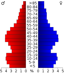
In the county, the population was spread out with 26.80% under the age of 18, 8.20% from 18 to 24, 29.50% from 25 to 44, 22.50% from 45 to 64, and 13.00% who were 65 years of age or older. The median age was 36 years. For every 100 females there were 99.50 males. For every 100 females age 18 and over, there were 97.40 males.
Cities, villages, and towns
Cities
- Abbotsford ‡
- Colby ‡
- Marshfield ‡
Villages
- Unity ‡
- Weston
Towns
Unincorporated communities
- Bradley
- Cherokee
- Dancy
- Galloway
- Glandon
- Granite Heights
- Halder
- Hogarty
- Hamburg
- Little Chicago
- Little Rose
- Knowlton
- March Rapids
- Milan
- Moon
- Norrie
- Nutterville
- Pike Lake
- Poniatowski
- Rib Falls
- Ringle
- Rozellville
- Taegesville
- Shantytown
- Sunset
- Wien
- † Unincorporated community or annexed village
- ‡ Only partially in Marathon County
See also
References
- ^ "Marathon County Quickfacts". US Census Bureau. http://quickfacts.census.gov/qfd/states/55/55073.html. Retrieved 23 October 2011.
- ^ "Find a County". National Association of Counties. http://www.naco.org/Counties/Pages/FindACounty.aspx. Retrieved 2011-06-07.
- ^ "American FactFinder". United States Census Bureau. http://factfinder.census.gov. Retrieved 2008-01-31.
External links
Resources
This digital collection contains historic images and texts that document central Wisconsin schools and libraries in Marathon and Lincoln Counties. Text-based materials include: Marchetti, Louis. History of the Public Library Building and Names of Donors, 1909, a record of the proceedings, leading up, and culminating in the erection and completion of the Library Building of the city of Wausau, with names of Donors attached thereto. Compiled and presented to the Library by Louis Marchetti, President of the Library Board from 1904 to 1908.
The Marathon County Public Library (MCPL) has its headquarters located in downtown Wausau, Wisconsin, U.S.A. In addition to the MCPL - Wausau Headquarters, 8 branch libraries have been established in the cities of Athens, Edgar, Hatley, Marathon City, Mosinee, Rothschild, Spencer, and Stratford. The Marathon County Public Library catalog and electronic resources are also available online at www.mcpl.us.

Taylor County Lincoln County Langlade County 
Clark County 
Shawano County  Marathon County, Wisconsin

Wood County and Portage County Waupaca County Wausau, Wisconsin Surrounding
communities(over 10,000) (under 10,000) Brokaw‡ | Kronenwetter‡ | Maine* | Marathon* | Marathon City‡ | Mosinee° | Mosinee* | Rib Mountain*§ | Rothschild‡ | Schofield° | Stettin* | Wausau*
Counties Marathon CountyEducation University of Wisconsin-Marathon County • Northcentral Technical College • Wausau School District • D.C. Everest School District*town ‡village °city §CDP Marshfield, WI Surrounding
communities(under 10,000) 
Counties Marathon | Wood*town ‡village  State of Wisconsin
Madison (capital) Topics History · Governors · Delegations · Sports · People · Geography · Demographics · Economy · Visitor Attractions
Regions Major metropolitan areas
(pop. over 500,000)Chicago metropolitan area · Madison metropolitan area · Milwaukee metropolitan area · Twin Cities metropolitan area
Largest cities
(pop. over 50,000)Appleton · Eau Claire · Green Bay · Janesville · Kenosha · La Crosse · Madison · Milwaukee · Oshkosh · Racine · Waukesha · West Allis
Smaller cities
(pop. 15,000 to 50,000)Beaver Dam · Beloit · Brookfield · Cudahy · De Pere · Fitchburg · Fond du Lac · Franklin · Greenfield · Manitowoc · Marshfield · Menasha · Mequon · Middleton · Muskego · Neenah · New Berlin · Oak Creek · Onalaska · Sheboygan · South Milwaukee · Stevens Point · Sun Prairie · Superior · Watertown · Wausau · Wauwatosa · West Bend · Wisconsin Rapids
Largest villages
(pop. over 15,000)Counties Adams · Ashland · Barron · Bayfield · Brown · Buffalo · Burnett · Calumet · Chippewa · Clark · Columbia · Crawford · Dane · Dodge · Door · Douglas · Dunn · Eau Claire · Florence · Fond du Lac · Forest · Grant · Green · Green Lake · Iowa · Iron · Jackson · Jefferson · Juneau · Kenosha · Kewaunee · La Crosse · Lafayette · Langlade · Lincoln · Manitowoc · Marathon · Marinette · Marquette · Menominee · Milwaukee · Monroe · Oconto · Oneida · Outagamie · Ozaukee · Pepin · Pierce · Polk · Portage · Price · Racine · Richland · Rock · Rusk · Sauk · Sawyer · Shawano · Sheboygan · St. Croix · Taylor · Trempealeau · Vernon · Vilas · Walworth · Washburn · Washington · Waukesha · Waupaca · Waushara · Winnebago · Wood
Coordinates: 44°54′N 89°46′W / 44.90°N 89.76°W
Categories:- Wisconsin counties
- Marathon County, Wisconsin
- 1850 establishments in the United States
Wikimedia Foundation. 2010.


