- Crawford County, Wisconsin
-
Crawford County, Wisconsin 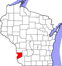
Location in the state of Wisconsin
Wisconsin's location in the U.S.Founded 1818 Named for William H. Crawford Seat Prairie du Chien Area
- Total
- Land
- Water
599 sq mi (1,552 km²)
573 sq mi (1,483 km²)
27 sq mi (69 km²), 4.43%Population
- (2000)
- Density
17,243
30/sq mi (12/km²)Website www.crawfordcountywi.org/ Crawford County is a county located in southwest Wisconsin, United States. Its county seat is Prairie du Chien.[1] Along with Brown County, it is one of Wisconsin's original counties, established by the Michigan Territorial legislature in 1818, and named after William H. Crawford, James Monroe's Treasurer at the time. Originally, it covered the entire western half of Wisconsin's present area. In 1836 it was transferred to the newly formed Wisconsin Territory as Michigan prepared for statehood and has gradually been subdivided into its present area.
As of July 2002, its population was estimated at 16,897, a loss of nearly 350 people from the 2000 census figure of 17,243.
Contents
Geography
According to the U.S. Census Bureau, the county has a total area of 599 square miles (1,551.4 km2). 573 square miles (1,484.1 km2) is land and 27 square miles (69.9 km2) (4.43%) is water, including 77 lakes.
Three rivers run through the county:
- The Kickapoo River, nicknamed "the crookedest river in Wisconsin" was carved out by glacial run-off. It is considered one of the best Class 1 paddling rivers in the Midwest.
- The Wisconsin River borders the county's southern edge. Although it is the busiest river in the state, its run within the county is tranquil, with high bluff escarpments and sandy islands.
- The Mississippi River, serves as the county's western border. The steep limestone cliffs are interspersed with bluffs and prairies.
Major highways
 U.S. Highway 18
 U.S. Highway 61
 Highway 35 (Wisconsin)
 Highway 27 (Wisconsin)
 Highway 60 (Wisconsin)
 Highway 82 (Wisconsin)
 Highway 131 (Wisconsin)
 Highway 171 (Wisconsin)
 Highway 179 (Wisconsin)
Adjacent counties
- Vernon County - north
- Richland County - east
- Grant County - south
- Clayton County, Iowa - southwest
- Allamakee County, Iowa - west
Demographics
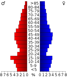 2000 Census Age Pyramid for Crawford County.
Historical populations Census Pop. %± 1900 17,286 — 1910 16,288 −5.8% 1920 16,772 3.0% 1930 16,781 0.1% 1940 18,328 9.2% 1950 17,652 −3.7% 1960 16,351 −7.4% 1970 15,252 −6.7% 1980 16,556 8.5% 1990 15,940 −3.7% 2000 17,243 8.2% 2010 16,644 −3.5% WI Counties 1900-1990 As of the census[2] of 2000, there were 17,243 people, 6,677 households, and 4,613 families residing in the county. The population density was 12/km² (30/sq mi). There were 8,480 housing units at an average density of 6/km² (15/sq mi). The racial makeup of the county was 97.31% White, 1.35% Black or African American, 0.21% Native American, 0.26% Asian, 0.01% Pacific Islander, 0.17% from other races, and 0.68% from two or more races. 0.75% of the population were Hispanic or Latino of any race. 33.6% were of German, 16.0% Norwegian, 11.4% Irish, 7.2% Czech, 7.2% English and 6.4% United States or American ancestry.
There were 6,677 households out of which 31.60% had children under the age of 18 living with them, 56.70% were married couples living together, 8.40% had a female householder with no husband present, and 30.90% were non-families. 26.70% of all households were made up of individuals and 13.00% had someone living alone who was 65 years of age or older. The average household size was 2.48 and the average family size was 3.00.
In the county, the population was spread out with 26.20% under the age of 18, 8.10% from 18 to 24, 25.00% from 25 to 44, 24.80% from 45 to 64, and 16.00% who were 65 years of age or older. The median age was 39 years. For every 100 females there were 102.20 males. For every 100 females age 18 and over, there were 99.30 males.
Cities, villages, and towns
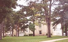 Crawford County Courthouse
- Bell Center
- Bridgeport
- Clayton
- Eastman (town)
- Eastman
- Ferryville
- Freeman
- Gays Mills
- Haney
- Lynxville
- Marietta
- Mount Sterling
- Prairie du Chien (town)
- Prairie du Chien
- Scott
- Seneca
- Soldiers Grove
- Steuben
- Utica
- Wauzeka (town)
- Wauzeka
Unincorporated communities
- Barnum
- Boydtown
- Charme
- Easter Rock
- Fairview
- Montgomeryville
- Mount Zion
- Petersburg
- Plugtown
- Rising Sun
- Rolling Ground
- Seneca
- Towerville
See also
- National Register of Historic Places listings in Crawford County, Wisconsin
- Upper Mississippi River National Wildlife and Fish Refuge
References
- ^ "Find a County". National Association of Counties. http://www.naco.org/Counties/Pages/FindACounty.aspx. Retrieved 2011-06-07.
- ^ "American FactFinder". United States Census Bureau. http://factfinder.census.gov. Retrieved 2008-01-31.
External links
- Official Crawford County government website
- Crawford County Health and Demographic Data
- History of Crawford and Richland Counties, Wisconsin

Vernon County Allamakee County, Iowa 
Richland County  Crawford County, Wisconsin

Clayton County, Iowa Grant County Municipalities and communities of Crawford County, Wisconsin City 
Villages Bell Center | Eastman | Ferryville | Gays Mills | Lynxville | Mount Sterling | Soldiers Grove | Steuben | Wauzeka
Towns Unincorporated
communitiesBarnum | Boydtown | Charme | Easter Rock | Fairview | Montgomeryville | Mount Zion | Petersburg | Plugtown | Rising Sun | Rolling Ground | Seneca | Towerville
Categories:- Wisconsin counties
- Crawford County, Wisconsin
- 1818 establishments in the United States
- Populated places established in 1818
- Wisconsin counties on the Mississippi River


Wikimedia Foundation. 2010.