- Green County, Wisconsin
-
Green County, Wisconsin 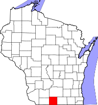
Location in the state of Wisconsin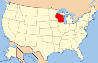
Wisconsin's location in the U.S.Founded information needed Seat Monroe Largest city Monroe Area
- Total
- Land
- Water
585 sq mi (1,514 km²)
584 sq mi (1,513 km²)
1 sq mi (2 km²), 0.10%Population
- (2000)
- Density
33,647
58/sq mi (22/km²)Time zone Central: UTC-6/-5 Website www.co.green.wi.gov Green County is a county located in the U.S. state of Wisconsin. As of 2000, the population was 33,647. Its county seat is Monroe[1].
Contents
Geography
According to the U.S. Census Bureau, the county has a total area of 585 square miles (1,515.1 km2), of which 584 square miles (1,512.6 km2) is land and 1 square mile (2.6 km2) (0.10%) is water.
Major highways
 Highway 11 (Wisconsin)
 Highway 39 (Wisconsin)
 Highway 59 (Wisconsin)
 Highway 69 (Wisconsin)
 Highway 78 (Wisconsin)
 Highway 81 (Wisconsin)
 Highway 92 (Wisconsin)
 Highway 104 (Wisconsin)
Adjacent counties
- Dane County, Wisconsin - north
- Rock County, Wisconsin - east
- Winnebago County, Illinois - southeast
- Stephenson County, Illinois - south
- Lafayette County, Wisconsin - west
- Iowa County, Wisconsin - northwest
Demographics
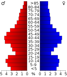 2000 Census Age Pyramid for Green County.
Historical populations Census Pop. %± 1900 22,719 — 1910 21,641 −4.7% 1920 21,568 −0.3% 1930 21,870 1.4% 1940 23,146 5.8% 1950 24,172 4.4% 1960 25,851 6.9% 1970 26,714 3.3% 1980 30,012 12.3% 1990 30,339 1.1% 2000 33,647 10.9% 2010 36,842 9.5% WI Counties 1900-1990 As of the census[2] of 2000, there were 33,647 people, 13,212 households, and 9,208 families residing in the county. The population density was 58 people per square mile (22/km²). There were 13,878 housing units at an average density of 24 per square mile (9/km²). The racial makeup of the county was 98.14% White, 0.26% Black or African American, 0.21% Native American, 0.29% Asian, 0.36% from other races, and 0.75% from two or more races. 0.97% of the population were Hispanic or Latino of any race. 31.9% were of German, 20.3% Swiss, 14.9% Norwegian, 6.7% Irish, 5.7% English and 5.5% American ancestry according to Census 2000. 96.5% spoke English, 2.0% German and 1.1% Spanish as their first language.
There were 13,212 households out of which 33.70% had children under the age of 18 living with them, 58.30% were married couples living together, 7.50% had a female householder with no husband present, and 30.30% were non-families. 25.00% of all households were made up of individuals and 11.20% had someone living alone who was 65 years of age or older. The average household size was 2.51 and the average family size was 3.01.
In the county, the population was spread out with 26.50% under the age of 18, 6.70% from 18 to 24, 29.20% from 25 to 44, 22.90% from 45 to 64, and 14.70% who were 65 years of age or older. The median age was 38 years. For every 100 females there were 96.90 males. For every 100 females age 18 and over, there were 94.20 males.
Cities, villages, and towns
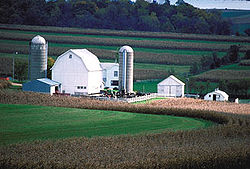 A farm in Green County, Wisconsin
- Adams (town)
- Albany (town)
- Albany (village)
- Belleville (village)
- Brodhead (city)
- Brooklyn (town)
- Browntown (village)
- Cadiz (town)
- Clarno (town)
- Decatur (town)
- Exeter (town)
- Jefferson (town)
- Jordan (town)
- Monroe (town)
- Monroe (city)
- Monticello (village)
- Mount Pleasant (town)
- New Glarus (town)
- New Glarus (village)
- Spring Grove (town)
- Sylvester (town)
- Washington (town)
- York (town)
Unincorporated communities
 Green County courthouse
- Attica
- Clarence
- Clarno
- Dayton
- Jordan Center
- Juda
- Martintown
- Postville
- Oakley
- Ross Crossing
- Schneyville
- Twin Grove
See also
References
- ^ "Find a County". National Association of Counties. http://www.naco.org/Counties/Pages/FindACounty.aspx. Retrieved 2011-06-07.
- ^ "American FactFinder". United States Census Bureau. http://factfinder.census.gov. Retrieved 2008-01-31.
External links

Iowa County Dane County Lafayette County 
Rock County  Green County, Wisconsin

Stephenson County, Illinois Winnebago County, Illinois Municipalities and communities of Green County, Wisconsin Cities 
Villages Albany | Belleville‡ | Brooklyn‡ | Browntown | Monticello | New Glarus
Towns Adams | Albany | Brooklyn | Cadiz | Clarno | Decatur | Exeter | Jefferson | Jordan | Monroe | Mount Pleasant | New Glarus | Spring Grove | Sylvester | Washington | York
CDP Juda
Unincorporated
communitiesAttica | Clarno | Dayton | Martintown | Oakley | Ross Crossing | Schneyville | Twin Grove
Footnotes ‡This populated place also has portions in an adjacent county or counties
Categories:- Wisconsin counties
- Green County, Wisconsin


Wikimedia Foundation. 2010.