- Ozaukee County, Wisconsin
-
Ozaukee County, Wisconsin 
Seal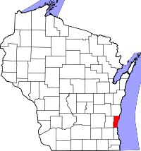
Location in the state of Wisconsin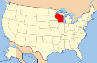
Wisconsin's location in the U.S.Founded information needed Seat Port Washington Largest city Mequon Area
- Total
- Land
- Water
1,116 sq mi (2,890 km²)
232 sq mi (601 km²)
884 sq mi (2,290 km²), 79.22%Population
- (2010)
- Density
86,395
373/sq mi (144/km²)Website www.co.ozaukee.wi.us Ozaukee County is a county in the U.S. state of Wisconsin. As of 2010, the population was 86,395. Its county seat is Port Washington[1]. Ozaukee County is the smallest in area of any county in the state of Wisconsin. As of the 2000 Census, Ozaukee County had the 2nd lowest poverty rate of any county in the United States, at 2.6%. In terms of per capita income, it is the 25th wealthiest county in the country. Bolstered by low crime rates and school districts with high graduation rates, Forbes Magazine ranked Ozaukee County #2 on its list of "America's Best Places To Raise A Family" in June, 2008.[2]
Contents
History
Ozaukee County was once part of neighboring Washington County to the west. Its name comes from the Ojibwe name for the Sacs.[3] The word probably means "people living at the mouth of a river."[4]
Geography
According to the U.S. Census Bureau, the county has a total area of 2,891 km² (1,116sq mi). 232 square miles (601 km²) of it is land and 884 square miles (2,290 km²) of it (79.22%) is water.
Major highways
 Interstate 43
 Highway 32 (Wisconsin)
 Highway 33 (Wisconsin)
 Highway 57 (Wisconsin)
 Highway 60 (Wisconsin)
 Highway 167 (Wisconsin)
 Highway 181 (Wisconsin)
Adjacent counties
- Sheboygan County - north
- Oceana County, Michigan - northeast, across Lake Michigan
- Muskegon County, Michigan - east, across Lake Michigan
- Milwaukee County - south
- Waukesha County - southwest
- Washington County - west
Demographics
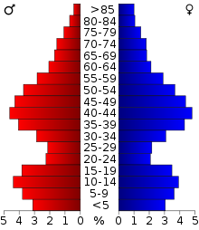 2000 Census Age Pyramid for Ozaukee County.
Historical populations Census Pop. %± 1860 15,682 — 1870 15,564 −0.8% 1880 15,461 −0.7% 1890 14,943 −3.4% 1900 16,363 9.5% 1910 17,123 4.6% 1920 16,335 −4.6% 1930 17,394 6.5% 1940 18,985 9.1% 1950 23,361 23.0% 1960 38,441 64.6% 1970 54,421 41.6% 1980 66,981 23.1% 1990 72,831 8.7% 2000 82,317 13.0% 2010 86,395 5.0% Source: U.S. Census[5] 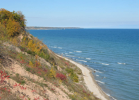 Lake Michigan shoreline, near Port Washington
As of the census[6] of 2000, there were 82,317 people, 30,857 households, and 23,019 families residing in the county. The population density was 355 people per square mile (137/km²). There were 32,034 housing units at an average density of 138 per square mile (53/km²). The racial makeup of the county was 96.72% White, 0.93% Black or African American, 0.20% Native American, 1.07% Asian, 0.02% Pacific Islander, 0.34% from other races, and 0.73% from two or more races. 1.30% of the population were Hispanic or Latino of any race. 47.2% were of German, 7.3% Irish and 6.7% Polish ancestry according to Census 2000. 95.1% spoke English, 1.6% Spanish and 1.4% German as their first language.
There were 30,857 households out of which 36.00% had children under the age of 18 living with them, 65.60% were married couples living together, 6.50% had a female householder with no husband present, and 25.40% were non-families. 21.40% of all households were made up of individuals and 8.40% had someone living alone who was 65 years of age or older. The average household size was 2.61 and the average family size was 3.07.
In the county, the population was spread out with 26.60% under the age of 18, 6.80% from 18 to 24, 28.00% from 25 to 44, 25.90% from 45 to 64, and 12.60% who were 65 years of age or older. The median age was 39 years. For every 100 females there were 97.30 males. For every 100 females age 18 and over, there were 94.00 males.
The median income for a household in the county was $62,745, and the median income for a family was $72,547 (these figures had risen to $73,197 and $88,231 respectively as of a 2007 estimate[7]). Males had a median income of $50,044 versus $30,476 for females. The per capita income for the county was $31,947. About 1.7% of families and 2.6% of the population were below the poverty line, including 2.6% of those under age 18 and 4.1% of those age 65 or over.
Government
- County Executive: none
- District Attorney: Adam Gerol
- Sheriff: Maury Straub (R)
Cities, towns, and villages
Cities
Villages
Towns
Unincorporated communities
See also
References
- ^ "Find a County". National Association of Counties. http://www.naco.org/Counties/Pages/FindACounty.aspx. Retrieved 2011-06-07.
- ^ "America's Best Places To Raise A Family". Forbes. 2008-06-30. http://www.forbes.com/home/2008/06/27/schools-places-family-forbeslife-cz_zg_0630realestate.html.
- ^ Wisconsin Historical Society: Term: Ozaukee County [origin of place name]. http://www.wisconsinhistory.org/dictionary/index.asp?action=view&term_id=3715&term_type_id=2&term_type_text=places&letter=O
- ^ Wisconsin Historical Society
- ^ Southeastern Wisconsin Regional Planning Commission (July 2004) (PDF). The Population of Southeastern Wisconsin. Technical Report Number 11 (4th Edition). http://www.sewrpc.org/publications/techrep/tr-011_population_southeastern_wisconsin.pdf. Retrieved 2007-04-09.
- ^ "American FactFinder". United States Census Bureau. http://factfinder.census.gov. Retrieved 2008-01-31.
- ^ "Ozaukee County, Wisconsin - Fact Sheet - American FactFinder". Factfinder.census.gov. http://factfinder.census.gov/servlet/ACSSAFFFacts?_event=Search&geo_id=05000US55089&_geoContext=01000US%7C04000US55%7C05000US55089&_street=&_county=ozaukee&_cityTown=ozaukee&_state=04000US55&_zip=&_lang=en&_sse=on&ActiveGeoDiv=geoSelect&_useEV=&pctxt=fph&pgsl=050&_submenuId=factsheet_1&ds_name=ACS_2007_3YR_SAFF&_ci_nbr=null&qr_name=null®=null%3Anull&_keyword=&_industry=. Retrieved 2010-07-22.
External links

Sheboygan County Oceana County, Michigan Washington County 
Muskegon County, Michigan  Ozaukee County, Wisconsin

Waukesha County Milwaukee County Milwaukee Metropolitan Area Central City 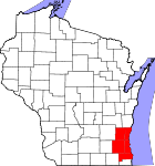
Largest Municipalities
(over 25,000 in 2000)BrookfieldC · FranklinC · GreenfieldC · Menomonee FallsV · New BerlinC · Oak CreekC · RacineC · WaukeshaC · WauwatosaC · West AllisC · West BendC
Municipalities
(over 10,000 in 2000)Brown DeerV · CaledoniaV · CedarburgC · CudahyC · GermantownV · GlendaleC · GraftonV · GreendaleV · MequonC · MuskegoC · OconomowocC · PewaukeeC · RichfieldT · ShorewoodV · South MilwaukeeC · Whitefish BayV
Smaller Municipalities
(under 10,000 in 2000)BaysideV · Big BendV · BrookfieldT · Elm GroveV · Fox PointV · HartlandV · Hales CornersV · MukwonagoV · PewaukeeV · River HillsV · SaukvilleV · Saint FrancisC · SussexV · ThiensvilleV · West MilwaukeeV
Counties Milwaukee · Ozaukee · Racine · Washington · Waukesha
Municipalities and communities of Ozaukee County, Wisconsin Cities 
Villages Towns CDP Waubeka
Unincorporated
communitiesFootnotes ‡This populated place also has portions in an adjacent county or counties
Coordinates: 43°23′55″N 87°53′37″W / 43.398475°N 87.893572°W
Categories:- Wisconsin counties
- Ozaukee County, Wisconsin


Wikimedia Foundation. 2010.