- Wauwatosa, Wisconsin
Infobox Settlement
official_name = Wauwatosa, Wisconsin
settlement_type =City 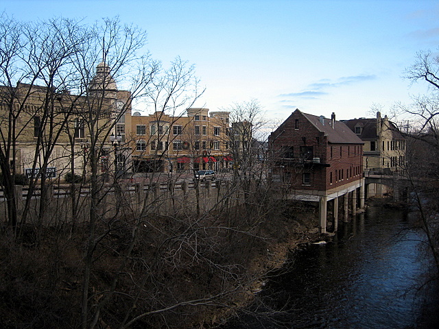
imagesize =
image_caption = Village of Wauwatosa along the banks of the Menomonee River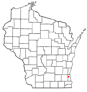
mapsize = 250x200px
map_caption =
mapsize1 =
map_caption1 =
subdivision_type = Country
subdivision_name =United States
subdivision_type1 = State
subdivision_name1 =Wisconsin
subdivision_type2 = County
subdivision_name2 = Milwaukee
government_type =
leader_title = Mayor
leader_name =Jill Didier
leader_title1 = Congressional Rep.
leader_name1 =Jim Sensenbrenner (R)
established_date =
unit_pref = Imperial
area_magnitude =
area_total_km2 = 21.24
area_land_km2 = 34.3
area_water_km2 = 2.41
area_total_sq_mi = 13.20
area_land_sq_mi = 13.2
area_water_sq_mi = 1.50
area_water_percent = 11.35
population_as_of = 2006
population_total = 44,798
population_metro = 1,753,355
population_density_km2 = 2,119.30
population_density_sq_mi = 3,410.15
timezone = Central
utc_offset = -6
elevation_m = 205
elevation_ft = 673
latd = 43 |latm = 03 |lats = 32 |latNS = N
longd = 88 |longm = 01 |longs = 34 |longEW = W
timezone_DST = CDT
utc_offset_DST = -5
postal_code_type =
postal_code =
area_code = 414
blank_name = FIPS code
blank_info = 55-84675GR|2
blank1_name = GNIS feature ID
blank1_info = 1576335GR|3
footnotes =
website = http://www.wauwatosa.netWauwatosa is a city in Milwaukee County,
Wisconsin ,United States , and was incorporated onMay 27 ,1897 . [cite web |url=http://192.159.83.40/SOS/pdf/THEOSOS_014/images/00008816.pdf |title=CITY OF WAUWATOSA INCORPORATED MAY 27, 1897 UNDER GENERAL LAW, RECORDED IN MISC. REC. VOL. 5, PG. 397; BOUNDARY DESCRIPTION |accessdate=2007-04-08 |author=Village of Wauwatosa |publisher=Office of the Secretary of State of Wisconsin] As of the 2006 census estimate, the city's population was 44,798. Wauwatosa is located immediately west ofMilwaukee, Wisconsin , and is a part of theMilwaukee metropolitan area . It is named after thePotawatomi word forfirefly .Wauwatosa contains Milwaukee County's Regional Medical Center, which includes the
Medical College of Wisconsin , Children's Hospital of Wisconsin, and Froedtert Hospital, one of two level-onetrauma center s in the state. Other points of interest are theAnnunciation Greek Orthodox Church designed byFrank Lloyd Wright ; and the Memorial Center, built in 1957, which contains a public library, an auditorium, and the city hall. The Washington Highlands, a residential neighborhood designed in 1916 by renowned city plannerWerner Hegemann , was added to theNational Register of Historic Places in 1989.History
The lush Menomonee River Valley of the Wauwatosa area provided a key overland gateway between the rich glacial farmland of southeastern Wisconsin and the Port of Milwaukee. In 1835, Charles Hart became the first permanent white settler, followed by seventeen other families the same year. The following year a United States Road was built from Milwaukee through Wauwatosa, eventually reaching Madison.
The Town of Wauwatosa was created by act of the Wisconsin Territorial Legislature in 1840, and the town government was organized in 1842. The town's borders originally extended from Greenfield Avenue in the south to Hampton Avenue in the north, and from 27th Street in the east to the Waukesha County line in the west, encompassing sections of present-day Milwaukee and West Allis. Most of the town was farmland through the remainder of the nineteenth century.
In 1849 the Watertown Plank Road was constructed through Wauwatosa, mainly following the old Madison territorial road. In 1851 Wisconsin's first railroad (later becoming
The Milwaukee Road ) established Wauwatosa as its western terminus. The Village of Wauwatosa was incorporated from the central part of the Town of Wauwatosa in 1892, and was recharted as the City of Wauwatosa in 1897.In the 1950s, the City of Wauwatosa more than doubled its size by annexing 8.5 square miles (22 km²) of land west of the Menomonee River from the Town of Wauwatosa, which became the home to several large cold storage and regional food distribution terminals. Industrial plants owned by firms includingHarley-Davidson andBriggs & Stratton were also constructed.In the past 40 years, western Wauwatosa has become an
edge city with an important commercial and retail district built up along Milwaukee's beltline Highway 100 and anchored by theMayfair Mall .Wauwatosa received some national attention in 1992 when the Wauwatosa Common Council, threatened with a lawsuit, decided to remove a
Christian cross from the City's seal adopted in 1957.Geography
Wauwatosa is located at coor dms|43|3|32|N|88|1|34|W|city (43.058862, -88.026162)GR|1.According to the
United States Census Bureau , the city has a total area of 13.2 square miles (34.3 km²), none of which, except for the Menomonee River, is covered with water.Eastern Wauwatosa is also known for its homes and residential streets, at one time just a short streetcar ride away from downtown Milwaukee. Prior to the arrival of
Dutch elm disease , many of Wauwatosa's older residential streets had large gothic colonnades ofAmerican Elm trees. In Wauwatosa, the Menomonee Valley made it easier to quarry portions of theNiagara Escarpment , which provided the necessary materials for sturdy cream colored bricks and stout limestone foundations used in many homes and public buildings throughout the region.Demographics
USCensusPop
1900=2842
1910=3346
1920=5818
1930=21194
1940=27769
1950=33324
1960=56923
1970=58676
1980=51310
1990=49484
2000=47271
estimate=45015
estyear=2005
footnote=Note: Town of Wauwatosa annexed in 1952-54.As of the
census estimate GR|2 of 2004, there were 45,602 people, 20,388 households, and 12,314 families residing in the city. Thepopulation density was 3,570.5 people per square mile (1,378.5/km²). There were 20,917 housing units at an average density of 1,579.9/sq mi (610.0/km²). The racial makeup of the city was 93.97% White, 2.04% African American, 0.27% Native American, 1.94% Asian, 0.07% Pacific Islander, 0.54% from other races, and 1.17% from two or more races. Hispanic or Latino of any race were 1.72% of the population.There were 20,388 households out of which 28.3% had children under the age of 18 living with them, 50.0% were married couples living together, 7.9% had a female householder with no husband present, and 39.6% were non-families. 33.9% of all households were made up of individuals and 15.4% had someone living alone who was 65 years of age or older. The average household size was 2.27 and the average family size was 2.96.
In the city the population was spread out with 23.3% under the age of 18, 5.5% from 18 to 24, 31.2% from 25 to 44, 21.9% from 45 to 64, and 18.2% who were 65 years of age or older. The median age was 39 years. For every 100 females there were 86.3 males. For every 100 females age 18 and over, there were 81.9 males.
The median income for a household in the city was $54,519, and the median income for a family was $68,030. Males had a median income of $46,721 versus $35,289 for females. The
per capita income for the city was $28,834. About 2.3% of families and 3.8% of the population were below thepoverty line , including 3.9% of those under age 18 and 5.5% of those age 65 or over.Education
The city has one public school district, the [http://cms2.wauwatosa.k12.wi.us Wauwatosa School District]
High School s: Wauwatosa West, Wauwatosa EastMiddle School s: Whitman, LongfellowElementary School s: Eisenhower, Jefferson, Lincoln, Madison, McKinley, Roosevelt, Underwood, Washington, WilsonThere are also numerous Catholic elementary schools in the city: St. Bernard, St. Joseph, St. Jude, St. Pius X, and Christ King.
According to the 2000 U.S. Census, of Wauwatosa residents 25 years of age and older, 93.4% were high school graduates or better, and 47.6% had a bachelor's degree or better.
References
External links
* [http://www.wauwatosa.net/ City of Wauwatosa]
* [http://www.wauwatosanow.com Wauwatosa Now]
* [http://washingtonhighlands.org/ The Washington Highlands]
* [http://www.wauwatosahistoricalsociety.org Wauwatosa Historical Society]
Wikimedia Foundation. 2010.