- Wisconsin River
Infobox River | river_name = Wisconsin River
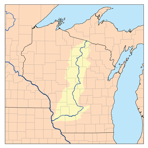
caption = Wisconsin and the Wisconsin River
origin =Lac Vieux Desert
mouth =Mississippi River nearPrairie du Chien, Wisconsin
basin_countries =United States
length = 430 mi (692 km)
elevation = 1,683 ft (513 m)
discharge = 12,000 ft³/s (340 m³/s) at mouth
watershed = 12,280 mi² (31,805 km²)The Wisconsin River is a
tributary of theMississippi River in theU.S. state ofWisconsin . At approximately 430 miles (692 km) long, it is the state's longest river. The river's name, first recorded in 1673 byJacques Marquette as "Meskousing," is rooted in theAlgonquian language s used by the area's American Indian tribes, but its original meaning is obscure. French explorers who followed in the wake of Marquette later modified the name to "Ouisconsin." This was simplified to "Wisconsin" in the early 19th century before being applied toWisconsin Territory and finally the state of Wisconsin.The Wisconsin River originates in the
forest s of the Lake District of northern Wisconsin, inLac Vieux Desert near the border of theUpper Peninsula of Michigan . It flows south across the glacial plain of central Wisconsin, passing Wausau and Stevens Point. In southern Wisconsin it encounters the terminal moraine formed during the lastice age , where it forms theDells of the Wisconsin River . North of Madison at Portage, the river turns to the west, flowing through Wisconsin's hillyWestern Upland and joining the Mississippi approximately 3 miles (4.8 km) south of Prairie du Chien. Although the river was originally navigable up to the city of Portage 200 miles (320 km) from its mouth, it is now considered non-navigable beyond the lock and dam at Prairie du Sac. [ [http://frwebgate.access.gpo.gov/cgi-bin/getdoc.cgi?dbname=browse_usc&docid=Cite:+33USC59aa 33USC59aa "Nonnavigability of Wisconsin River"] AccessedJuly 5 ,2006 .]Geology
The modern Wisconsin River was formed in several stages. The lower, westward-flowing portion of the river is located in the unglaciated
Driftless Area , and this section of the river's course likely predates the rest by several million years. The lower reach of the river is narrower than its upstream valley, leading to the suggestion the upper portions of the ancestor of the river flowed east previous to thePleistocene . [Steven Dutch, [http://www.uwgb.edu/DutchS/geolwisc/GEOHIST/WiPrePleist.htm "Possible Early Pleistocene Drainage in Wisconsin"] , RetrievedJuly 17 ,2007 ] The remaining length of the river was formed gradually as glaciers advanced and retreated over Wisconsin. The stretch of river from Stevens Point north to Merrill was a drainage route for meltwater flowing away from glaciers which covered northern Wisconsin during theWisconsin Glaciation . As the glaciers retreated further northward, the river also grew in that direction. South from Stevens Point, the meltwater would have flowed intoGlacial Lake Wisconsin , a prehistoricproglacial lake that existed in the central part of the state. As temperatures warmed around 15,000 years ago, the ice dam holding the lake in place burst, unleashing a catastrophic flood that carved theDells of the Wisconsin River and joined the upper stretches of the river with the pre-existing lower river valley that today flows from Portage to Prairie du Chien.History
The first documented exploration of the Wisconsin River by Europeans took place in 1673, when Jacques Marquette and
Louis Jolliet ofFrance canoed fromLake Michigan up the Fox River until reaching the present-day site of Portage in early June. At this location the Wisconsin and Fox rivers are only 2 miles (3.2 km) distant, so the explorers couldportage from the Fox to the Wisconsin River. They then continued downstream 200 miles (320 km) to the Wisconsin's mouth, entering the Mississippi onJune 17 . Other explorers and traders would follow the same route, and for the next 150 years the Wisconsin and Fox rivers, collectively known as theFox-Wisconsin Waterway , formed a major transportation route between theGreat Lakes and the Mississippi River.Industry began to form on the Wisconsin in the early 19th century, as loggers started using the river to raft logs downstream from northern forests to sawmills in new cities like Wausau. By the 1880s, logging companies were
dam ming the river to ensure the river had enough capacity for the logs being floated downstream. Later, at the start of the 20th century, more dams were constructed to provide for flood control andhydroelectricity . The dams also spurred tourism, creating reservoirs such asLake Wisconsin that are popular areas for recreational boating and fishing. Today the Wisconsin is impounded in 26 places.Despite this, a 93-mile (150 km) stretch of the Wisconsin between its mouth and the hydroelectric dam at Prairie du Sac is free of any dams or barriers and is relatively free-flowing. In the late 1980s, this portion of the river was designated as a state riverway, and development alongside the river has been limited to preserve its scenic integrity.
Lower Wisconsin River state riverway
The Lower Wisconsin River State Riverway is a state-funded project designed to protect the southern portion of the
Wisconsin River fromSauk City about 93 miles all the way to the point where the Wisconsin River joins and empties into the Mississippi, about 10 miles south of the town ofPrairie du Chien . The Wisconsin Department of Natural Resources manages protected lands of over 75,000 acres, including the river itself, islands, and some lands adjacent to the river. [ [http://www.eriksadventures.com Erik's Adventures Wisconsin River Canoeing] ]There are no dams or manmade obstructions to the natural flow of water from the hydroelectric dam just north of Sauk City all the way to where the Wisconsin joins the Mississippi. This long stretch of free-flowing river provides important natural habitats for a variety of wildlife, including white-tail deer, otter, beaver, turtles, sand hill cranes, eagles, hawks, and a variety of fish species.
There are many different recreation opportunities on the lower Wisconsin River from fishing and canoeing to tubing and camping.
Cities and villages along the river
columns-list|3
*Merrill
*Merrimac
*Mosinee
*Muscoda
*Nekoosa
*Okee
*Plover
*Port Edwards
*Portage
*Prairie du Sac
*Rhinelander
*Rothschild
*Sauk City
*Schofield
*Spring Green
*Stevens Point
*Tomahawk
*Wausau
*Whiting
*Wisconsin Dells
*Wisconsin Rapidsee also
*
List of Wisconsin rivers Notes
External links
* [http://www.wisconsinrivers.org River Alliance of Wisconsin]
* [http://www.wvic.com/Wisconsin-River-Mark-Morgan.htm Report on the Wisconsin River by Mark Morgan]
* [http://www.wisconsinhistory.org/topics/wisconsin-name/ Wisconsin's Name: Where It Came From and What It Means] , Wisconsin Historical Society
* [http://lwr.state.wi.us/ Lower Wisconsin State Riverway Board]
Wikimedia Foundation. 2010.