- Muscoda, Wisconsin
-
Muscoda, Wisconsin — Village — 
Coordinates: 43°10′29″N 90°28′20″W / 43.17472°N 90.47222°WCoordinates: 43°10′29″N 90°28′20″W / 43.17472°N 90.47222°W Country United States State Wisconsin Counties Grant, Iowa Area - Total 1.4 sq mi (3.5 km2) - Land 1.4 sq mi (3.5 km2) - Water 0.0 sq mi (0.0 km2) Elevation[1] 725 ft (221 m) Population (2000) - Total 1,453 - Density 1,069.1/sq mi (412.5/km2) Time zone Central (CST) (UTC-6) - Summer (DST) CDT (UTC-5) FIPS code 55-55225[2] GNIS feature ID 1583774[1] Muscoda is a village in Grant and Iowa counties in the U.S. state of Wisconsin. The population was 1,453 at the 2000 census. The Grant County part of the village lies in the town of Muscoda, while the Iowa County portion lies in the town of Pulaski, and is the largest village in the county, and third largest community.
Contents
History and culture
Muscoda (pronounced MUS-co-day) was originally known as English Prairie, named for two English fur traders, Abraham Lansing and Garrit Roseboom, who opened a post at the close of the French and Indian War. Lansing and his son were murdered in 1763 by their French assistants and the fame of the murder kept the name English Prairie alive until 1840.[3]
The word Muscoda (pronounced "MUS-co-day") may be a corruption of the Ojibwa (Chippewa) word mashkode, meaning "prairie".[4] The name was evidently taken from Longfellow's Hiawatha, in which it is mentioned several times:
"He had struck the deer and bison, On the Muskoday, the meadow"
and
"On the Muskoday, the meadow, On the prairie full of blossoms"
This is most likely how Muscoda earned its name, from the popular meaning of "Prairie of Flowers."[5]
Muscoda has billed itself as the "Wisconsin's Morel Capital" since 1982 and hosts the "Morel Mushroom Festival" every year on the weekend following Mother's Day.[6] The event includes carnival rides, tractors pulls, tournaments, merchant stands, food booths, and portable tattoo parlors.
Geography
Muscoda is located at 43°11′18″N 90°26′26″W / 43.18833°N 90.44056°W (43.188457, -90.440775),[7] on the Wisconsin River. Large rolling hills board the south of the town covered in mixed hardwoods made up of mainly Maple, Red/White Oak, Aspen, Cherry, Elm, and Walnut. 2,100 acres (8.5 km2) of public land hug both the east and west sides of Muscoda. These public lands hold a great deal of wildlife for sporstmen and wildlife enthusiast alike.
According to the United States Census Bureau, the village has a total area of 1.4 square miles (3.5 km²), all land.
Demographics
As of the census[2] of 2000, there were 1,453 people, 610 households, and 384 families residing in the village. The population density was 1,069.1 people per square mile (412.5/km²). There were 661 housing units at an average density of 486.3 per square mile (187.7/km²). The racial makeup of the village was 98.42% White, 0.28% Black or African American, 0.21% Native American, 0.07% Asian, and 1.03% from two or more races. Hispanic or Latino of any race were 1.31% of the population.
There were 610 households out of which 29.7% had children under the age of 18 living with them, 46.9% were married couples living together, 11.0% had a female householder with no husband present, and 36.9% were non-families. 32.1% of all households were made up of individuals and 15.6% had someone living alone who was 65 years of age or older. The average household size was 2.30 and the average family size was 2.88.
In the village the population was spread out with 23.6% under the age of 18, 7.8% from 18 to 24, 27.3% from 25 to 44, 21.3% from 45 to 64, and 20.0% who were 65 years of age or older. The median age was 39 years. For every 100 females there were 94.0 males. For every 100 females age 18 and over, there were 88.8 males.
The median income for a household in the village was $30,903, and the median income for a family was $38,750. Males had a median income of $29,853 versus $21,058 for females. The per capita income for the village was $15,390. About 7.9% of families and 10.2% of the population were below the poverty line, including 16.3% of those under age 18 and 9.3% of those age 65 or over.
Education
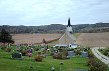 Graveyard near Muscoda
Riverdale High School, which is part of the Riverdale School District, is in Muscoda.
Business and industry
Muscoda is home of the Meister Cheese Company, which produces gourmet cheese.[8]
References
- ^ a b "US Board on Geographic Names". United States Geological Survey. 2007-10-25. http://geonames.usgs.gov. Retrieved 2008-01-31.
- ^ a b "American FactFinder". United States Census Bureau. http://factfinder.census.gov. Retrieved 2008-01-31.
- ^ English Prairie [origin of place name]
- ^ Word Definition
- ^ Hiawatha; a poem, by Henry Wadsworth Longfellow. Illustrated by John Rea Neill
- ^ Morel Mushroom Festival
- ^ "US Gazetteer files: 2010, 2000, and 1990". United States Census Bureau. 2011-02-12. http://www.census.gov/geo/www/gazetteer/gazette.html. Retrieved 2011-04-23.
- ^ Meister Cheese Company
External links
- Muscoda, Wisconsin
- Muscoda, 1763-1856 Reprinted from the Wisconsin Magazine of History
- Muscoda Topographic Map, 1983 (7 MB TIFF) From the U.S. Geological Survey (Symbol explanation)
Municipalities and communities of Grant County, Wisconsin County seat: Lancaster Cities Boscobel | Cuba City‡ | Fennimore | Lancaster | Platteville

Villages Bagley | Bloomington | Blue River | Cassville | Dickeyville | Hazel Green‡ | Livingston‡ | Montfort‡ | Mount Hope | Muscoda‡ | Patch Grove | Potosi | Tennyson | Woodman
Towns Beetown | Bloomington | Boscobel | Cassville | Castle Rock | Clifton | Ellenboro | Fennimore | Glen Haven | Harrison | Hazel Green | Hickory Grove | Jamestown | Liberty | Lima | Little Grant | Marion | Millville | Mount Hope | Mount Ida | Muscoda | North Lancaster | Paris | Patch Grove | Platteville | Potosi | Smelser | South Lancaster | Waterloo | Watterstown | Wingville | Woodman | Wyalusing
CDPs Glen Haven | Kieler | Sandy Hook
Unincorporated
communitiesAnnaton | Arthur | Bigpatch | British Hollow | Brodtville | Burton | Centerville | Cornelia | Ellenboro | Elmo | Fair Play | Five Points | Flora Fountain | Georgetown | Hickory Grove | Hurricane | Lancaster Junction | Louisburg | McCartney | Millville | Mount Ida | Prairie Corners | Rockville | Rutledge | Saint Rose | Sinsinawa | Stitzer | Union | Wyalusing
Footnotes ‡This populated place also has portions in an adjacent county or counties
Municipalities and communities of Iowa County, Wisconsin County seat: Dodgeville Cities 
Villages Arena | Avoca | Barneveld | Blanchardville‡ | Cobb | Highland | Hollandale | Linden | Livingston‡ | Montfort‡ | Muscoda‡ | Rewey | Ridgeway
Towns CDP Edmund
Unincorporated
communitiesGhost town Pendarvis
Footnotes ‡This populated place also has portions in an adjacent county or counties
Categories:- Villages in Wisconsin
- Populated places in Grant County, Wisconsin
- Populated places in Iowa County, Wisconsin


Wikimedia Foundation. 2010.