- Chopin, Louisiana
-
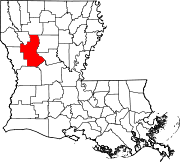
Chopin — Unincorporated community — Location within the state of Louisiana Coordinates: 31°29′49″N 92°51′34″W / 31.49694°N 92.85944°WCoordinates: 31°29′49″N 92°51′34″W / 31.49694°N 92.85944°W Country United States State Louisiana Parish Natchitoches Time zone Central (CST) (UTC-6) – Summer (DST) CDT (UTC-5) ZIP codes FIPS code GNIS feature ID 543085[1] Chopin is an unincorporated community in Natchitoches Parish, Louisiana, United States. It is located approximately 19 miles (31 km) southeast of Natchitoches near the intersection of Interstate 49 (exit 113) and Louisiana Highway 490.
The community is part of the Natchitoches Micropolitan Statistical Area.
References
Municipalities and communities of Natchitoches Parish, Louisiana City Town Villages Unincorporated
communitiesAllen | Ajax | Chopin | Cloutierville | Flora | Grand Ecore | Marthaville | Melrose | Mink | Readhimer
Categories:- Populated places in Natchitoches Parish, Louisiana
- Unincorporated communities in Louisiana
Wikimedia Foundation. 2010.


