- Interstate 55
-
Interstate 55
Route information Length: 964.25 mi[1] (1,551.81 km) Major junctions South end:  I-10 in Laplace, LA
 I-20 in Jackson, MS
 I-40 near Memphis, TN
 I-44 in St. Louis, MO

 I-64 / I-70 in St. Louis, MO
 I-80 near Joliet, IL

 I-90 / I-94 in Chicago, IL
North end:  US 41 in Chicago, IL
Highway system Main route of the Interstate Highway System
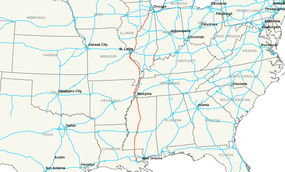
Main • Auxiliary • BusinessInterstate 55 (I-55) is an Interstate Highway in the central United States. Its odd number indicates that it is a north–south Interstate Highway. I-55 goes from LaPlace, Louisiana at Interstate 10 to Chicago at U.S. Route 41 (Lake Shore Drive), at McCormick Place. A common nickname for the highway is "double nickel."
The section of I-55 between Chicago and St. Louis was built as an alternate route for U.S. Highway 66. It crosses the Mississippi River twice: once at Memphis, Tennessee, and again at St. Louis, Missouri.
In 2009, officials in Green Bay, Wisconsin, began a campaign to have U.S. Route 41 in that area designated as I-55. A section of US 41 in Wisconsin is in the process of being rebuilt as an Interstate Highway. Some local officials in the Green Bay area think that designating US 41 as Interstate 55 would bring additional attention to that area. The main alternative is designating that highway as a spur of I-43.[2]
Contents
Route description
Lengths mi[1] km LA 65.81 105.91 MS 290.41 467.37 TN 12.28 19.76 AR 72.22 116.22 MO 210.45 338.69 IL 313.08 503.85 Total 964.25 1,551.81 Louisiana
In Louisiana, I-55 runs nearly 66 miles (106 km) from south to north, from Interstate 10 near Laplace (25 miles (40 km) west of New Orleans) to the Mississippi state line near Kentwood, Louisiana. Approximately 1/3 of the distance consists of the Manchac Swamp bridge, supposedly the third-longest viaduct in the world.
Mississippi
In Mississippi, I-55 runs 290.5 miles (467.5 km) from the Louisiana border near Osyka, Mississippi to Southaven on the Tennessee border, just south of Memphis. Noteworthy cities and towns that I-55 passes through or close by to are McComb, Jackson, and Grenada. This highway parallels U.S. 51 in its path roughly through the center of Mississippi.
The Mississippean section of I-55 is defined in the Mississippi Code § 65-3-3.
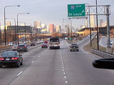
 I-44/55/64/70 on one highway sign in downtown St. Louis
I-55 in this area is sometimes called the Mississippi Delta Highway because of its proximity to the Mississippi River.[citation needed] The eight miles (13 km) from Hernando to the Tennessee state line coincide with the newer Interstate 69.
Tennessee
I-55 in Tennessee lies entirely within the city of Memphis, passing through the southern and western parts of the city and providing a bypass of downtown for motorists who do not want to take Interstates I-240 and I-40 through downtown to cross the Mississippi River. However, the western portion of this highway, which passes through an industrialized section of the city, contains numerous low-clearance bridges, and also a very tight 270 degree cloverleaf turn northbound at Crump Boulevard. The Tennessee Department of Transportation currently has an Interchange Improvement Project for this portion. Heavy truck traffic heading to and from Arkansas in this area is hence directed to detour via I-240 and I-40.
I-255 was the former numbering of I-240 between I-55 and I-40 through midtown Memphis, Tennessee.
 I-55 splits from I-40 here in West Memphis and heads north toward Jonesboro and the Missouri border.
Arkansas
I-55 enters Arkansas from Tennessee as it crosses the Mississippi river. It overlaps I-40 for approximately 2.8 miles (4.5 km) in West Memphis. After separating from I-40, I-55 turns northward and runs to the Missouri border, via the intersection with the stretch of U.S. 63 that holds the future alignment of the new Arkansas Interstate 555.
I-55 parallels U.S. 61 in its path through Arkansas, which it continues to do after crossing into Missouri.
Missouri
In Missouri, I-55 runs from the southeastern part of the state, at the Arkansas border, to St. Louis. In this city, Interstate 44 merges in with I-55, and both join Interstate 64 and Interstate 70 (on the Poplar Street Bridge), then cross the Mississippi River into Illinois.
Among the cities and towns served by I-55 in Missouri are Sikeston, Cape Girardeau, and St. Louis.
As noted above, I-55 parallels US Highway 61 for most of its course through Missouri, from the Arkansas border to the Southern portion of St. Louis County.
Illinois
I-55 largely follows the former U.S. 66 route through Illinois. Entering Illinois from the south, I-55, near the I-270/I-70 split, is referred to as the Paul Simon Freeway. This is in reference to the former U.S. Congressman Paul Simon from this region. Further north, between the St. Louis area and Springfield, I-55 is named The Vince Demuzio Expressway in reference to Illinois state politician Vince Demuzio. I-55 parallels the historic U.S. Route 66 from East St. Louis to Joliet, Illinois, passing around the state capital of Springfield, and also Bloomington.
When this expressway was being planned during the 1960s, the Illinois Governor Otto Kerner, Jr., made an effort to have the expressway routed close to the larger city of Peoria instead of the straighter route through the Bloomington-Normal area. This ultimately failed plan was ridiculed in the press as the "Kerner Curve". The transportation need of an expressway connection between Springfield and Peoria was later filled by the spur route Interstate 155. This also connects with nearby Lincoln and Morton and forms a triangle between the three population centers in Central Illinois.[3]
In the Chicago area, the expressway is referred to as the Adlai E. Stevenson Expressway in honor of Adlai E. Stevenson II.
Major intersections
- South End: Interstate 10 in Laplace, Louisiana
- Interstate 12 in Hammond, Louisiana
- Interstate 20 in Jackson, Mississippi (concurrent for two miles (3 km))
- Interstate 220 in Ridgeland, Mississippi
- Interstate 69 in Hernando, Mississippi
- Interstate 240 in southern Memphis, Tennessee
- Interstate 40 in West Memphis, Arkansas (concurrent for three miles.)
- Interstate 155 in Hayti, Missouri
- Interstate 57 east of Sikeston, Missouri
- Interstate 270 and Interstate 255 at Mehlville, Missouri, just south of St. Louis, Missouri (both intersections at the same interchange)
- Interstate 44 in St. Louis, Missouri
- Interstate 64 in St. Louis. These two highways stay the same across the Mississippi River to East St. Louis, Illinois.
- Interstate 70 in St. Louis. These two highways stay the same until an exit near Troy, Illinois.
- Interstate 255 just west of Collinsville, Illinois
- Interstate 270 east of Glen Carbon, Illinois
- Interstate 72 in Springfield, Illinois (concurrent for six miles)
- Interstate 155 west of Lincoln, Illinois
- Interstate 74 in Bloomington (concurrent for six miles)
- Interstate 39 in Bloomington
- Interstate 80 in Joliet, Illinois
- Interstate 355 in Bolingbrook, Illinois
- Interstate 294 in Burr Ridge, Illinois
- Interstate 90 and Interstate 94 (the Dan Ryan Expressway) in Chicago
- North end: US Highway 41 (Lake Shore Drive) in Chicago
Auxiliary routes
- Spur to Jonesboro, Arkansas - Interstate 555 (I-555), under construction
- Caruthersville, Missouri to Dyersburg, Tennessee - Interstate 155
- St. Louis, Missouri, area - Interstate 255 (I-255)
- Spur to Peoria, Illinois - Interstate 155
- In the southwestern suburbs of Chicago - Interstate 355 (I-355)
Auxiliary routes of Interstate 55 
References
- ^ a b "Route Log and Finder List — Interstate System: Table 1". FHWA. http://www.fhwa.dot.gov/reports/routefinder/table1.cfm. Retrieved 2007-09-26.
- ^ Green Bay Press Gazette 02-08-09
- ^ Unknown (2000-01-01). "Despite dead-end for I-55's Kerner Curve, I-74 changed area forever". Peoria Journal-Star. http://docs.newsbank.com/openurl?ctx_ver=z39.88-2004&rft_id=info:sid/iw.newsbank.com:NewsBank:PJSB&rft_val_format=info:ofi/fmt:kev:mtx:ctx&rft_dat=0EB6E83A6403BFAB&svc_dat=InfoWeb:aggregated5&req_dat=AA98CDC331574F0ABEAFF732B33DC0B2. Retrieved 2008-02-17.
External links
Main Interstate Highways (major interstates highlighted)
4 5 8 10 12 15 16 17 19 20 22 24 25 26 27 29 30 35 37 39 40 43 44 45 49 55 57 59 64 65 66 68 69 70 71 72 73 74 75 76 (W) 76 (E) 77 78 79 80 81 82 83 84 (W) 84 (E) 85 86 (W) 86 (E) 87 88 (W) 88 (E) 89 90 91 93 94 95 96 97 99 H-1 H-2 H-3 Unsigned A-1 A-2 A-3 A-4 PRI-1 PRI-2 PRI-3 Lists Primary Main - Intrastate - Suffixed - Temporary - Future - Gaps Auxiliary Main - Future - Unsigned Other Standards - Business - Bypassed - Tolled Browse numbered routes ←  MS 53
MS 53MS MS 57  →
→←  US 54
US 54MO US 56  →
→←  IL 54
IL 54IL IL 56  →Categories:
- Interstate 55
- Interstate Highway System
- U.S. Route 66
- Roads in Greater St. Louis
- Roads in St. Louis, Missouri
- Roads in St. Louis County, Missouri
- Roads in Madison County, Illinois
- Roads in Jefferson County, Missouri


Wikimedia Foundation. 2010.