- Osyka, Mississippi
-
Osyka, Mississippi — Town — Location of Osyka, Mississippi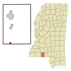
Coordinates: 31°0′26″N 90°28′16″W / 31.00722°N 90.47111°WCoordinates: 31°0′26″N 90°28′16″W / 31.00722°N 90.47111°W Country United States State Mississippi County Pike Area – Total 1.0 sq mi (2.7 km2) – Land 1.0 sq mi (2.7 km2) – Water 0.0 sq mi (0.0 km2) Elevation 266 ft (81 m) Population (2000) – Total 481 – Density 468.1/sq mi (180.8/km2) Time zone Central (CST) (UTC-6) – Summer (DST) CDT (UTC-5) ZIP code 39657 Area code(s) 601 FIPS code 28-54640 GNIS feature ID 0675322 Osyka is a town in Pike County, Mississippi, United States. The population was 481 at the 2000 census. It is part of the McComb, Mississippi Micropolitan Statistical Area.
Contents
Geography
Osyka is located at 31°0′26″N 90°28′16″W / 31.00722°N 90.47111°W (31.007196, -90.471165)[1].
According to the United States Census Bureau, the town has a total area of 1.0 square mile (2.6 km2), of which 1.0 square mile (2.6 km2) is land and 0.96% is water.
Demographics
As of the census[2] of 2000, there were 481 people, 193 households, and 132 families residing in the town. The population density was 468.1 people per square mile (180.3/km²). There were 234 housing units at an average density of 227.7 per square mile (87.7/km²). The racial makeup of the town was 53.01% White, 44.91% African American, 0.83% Native American, 0.42% Asian, and 0.83% from two or more races.
There were 193 households out of which 32.1% had children under the age of 18 living with them, 46.6% were married couples living together, 16.1% had a female householder with no husband present, and 31.6% were non-families. 31.6% of all households were made up of individuals and 19.2% had someone living alone who was 65 years of age or older. The average household size was 2.49 and the average family size was 3.12.
In the town the population was spread out with 28.9% under the age of 18, 8.7% from 18 to 24, 23.9% from 25 to 44, 19.8% from 45 to 64, and 18.7% who were 65 years of age or older. The median age was 35 years. For every 100 females there were 87.2 males. For every 100 females age 18 and over, there were 81.0 males.
The median income for a household in the town was $17,813, and the median income for a family was $25,078. Males had a median income of $21,750 versus $12,500 for females. The per capita income for the town was $11,550. About 27.1% of families and 29.8% of the population were below the poverty line, including 51.6% of those under age 18 and 25.8% of those age 65 or over.
Education
The Town of Osyka is served by the South Pike School District
References
- ^ "US Gazetteer files: 2010, 2000, and 1990". United States Census Bureau. 2011-02-12. http://www.census.gov/geo/www/gazetteer/gazette.html. Retrieved 2011-04-23.
- ^ "American FactFinder". United States Census Bureau. http://factfinder.census.gov. Retrieved 2008-01-31.
External links
- History of Osyka's Jewish community (from the Institute of Southern Jewish Life)
Municipalities and communities of Pike County, Mississippi Cities 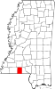
Towns Osyka | Summit
Unincorporated
communitiesChatawa | Fernwood | Pricedale
Categories:- Populated places in Pike County, Mississippi
- Towns in Mississippi
- McComb micropolitan area


Wikimedia Foundation. 2010.