- Summit, Mississippi
Infobox Settlement
official_name = Summit, Mississippi
settlement_type =Town
nickname =
motto =
imagesize =
image_caption =
image_
imagesize =
image_caption =
image_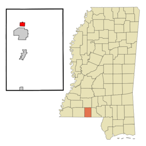
mapsize = 250px
map_caption = Location of Summit, Mississippi
mapsize1 =
map_caption1 =subdivision_type = Country
subdivision_name =United States
subdivision_type1 = State
subdivision_name1 =Mississippi
subdivision_type2 = County
subdivision_name2 = Pike
government_footnotes =
government_type =
leader_title =
leader_name =
leader_title1 =
leader_name1 =
established_title =
established_date =unit_pref = Imperial
area_footnotes =area_magnitude =
area_total_km2 = 4.4
area_land_km2 = 4.4
area_water_km2 = 0.0
area_total_sq_mi = 1.7
area_land_sq_mi = 1.7
area_water_sq_mi = 0.0population_as_of = 2000
population_footnotes =
population_total = 1428
population_density_km2 = 327.8
population_density_sq_mi = 848.9timezone = Central (CST)
utc_offset = -6
timezone_DST = CDT
utc_offset_DST = -5
elevation_footnotes =
elevation_m = 132
elevation_ft = 433
latd = 31 |latm = 16 |lats = 58 |latNS = N
longd = 90 |longm = 28 |longs = 0 |longEW = Wpostal_code_type =
ZIP code
postal_code = 39666
area_code = 601
blank_name = FIPS code
blank_info = 28-71480
blank1_name = GNIS feature ID
blank1_info = 0678402
website =
footnotes =Summit is a town in Pike County,
Mississippi , USA. The population was 1,428 at the 2000 census. It is part of theMcComb, Mississippi Micropolitan Statistical Area.The town originated as a railroad town and was named Summit because it is the highest point on the
Illinois Central Railroad between New Orleans,Louisiana and Jackson,Mississippi .Geography
Summit is located at 31°16'58" North, 90°28'0" West (31.282793, -90.466773)GR|1.
According to the
United States Census Bureau , the town has a total area of 1.7square mile s (4.4km² ), of which, 1.7 square miles (4.4 km²) of it is land and none of it is covered by water.Demographics
As of the
census GR|2 of 2000, there were 1,428 people, 589 households, and 394 families residing in the town. Thepopulation density was 848.9 people per square mile (328.2/km²). There were 658 housing units at an average density of 391.2/sq mi (151.2/km²). The racial makeup of the town was 32.63% White, 66.18% African American, 0.07% Asian, 0.14% from other races, and 0.98% from two or more races. Hispanic or Latino of any race were 0.42% of the population.There were 589 households out of which 33.4% had children under the age of 18 living with them, 38.5% were married couples living together, 24.3% had a female householder with no husband present, and 33.1% were non-families. 30.9% of all households were made up of individuals and 13.6% had someone living alone who was 65 years of age or older. The average household size was 2.41 and the average family size was 3.03.
In the town the population was spread out with 27.5% under the age of 18, 8.9% from 18 to 24, 27.2% from 25 to 44, 22.3% from 45 to 64, and 14.1% who were 65 years of age or older. The median age was 36 years. For every 100 females there were 83.8 males. For every 100 females age 18 and over, there were 77.8 males.
The median income for a household in the town was $21,053, and the median income for a family was $24,643. Males had a median income of $27,639 versus $17,000 for females. The
per capita income for the town was $12,928. About 26.3% of families and 30.4% of the population were below thepoverty line , including 46.3% of those under age 18 and 26.1% of those age 65 or over.Education
The Town of Summit is served by the
North Pike School District .References
External links
* [http://www.isjl.org/history/archive/ms/summit.htm History of Summit's Jewish community] (from the
Institute of Southern Jewish Life )
Wikimedia Foundation. 2010.