Vantage Bridge

Vantage Bridge

Infobox Bridge
bridge_name = Vantage Bridge
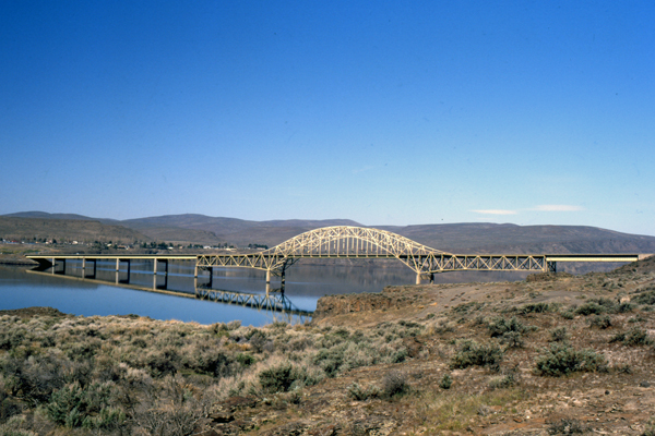


caption =
carries = Interstate 90
crosses = Columbia River
locale = Vantage, Washington
maint = Washington State DOT
id = 0006533A0000000
design = Through Arch
mainspan =
length = convert|763.2|m|ft|abbr=on
width =
height = convert|22.9|m|ft|abbr=on
traffic = 11,916 (2002)
begin =
complete = 1962
coordinates = coord|46|56|37|N|119|58|02|W|region:US_type:landmark|display=inline,title
The Vantage Bridge is a bridge in the U.S. state of Washington. It carries Interstate 90 across the Columbia River, near Vantage and George, Washington. This section of the river is named Wanapum Lake; it is the reservoir formed by Wanapum Dam. The bridge separates the Ginkgo Petrified Forest and Wanapum Recreational Area State Park on the western bank of the Columbia.

The current bridge is the second Vantage Bridge. The first was built in 1927 as part of the Sunset Highway (later US 10), a precursor to I-90. In 1962 the second bridge was built because the reservoir pool backing up behind the new Wanapum Dam would soon overwhelm the old bridge. The first bridge was dismantled. In 1968 its steel cantilever truss was reused for the Lyons Ferry Bridge, where SR 261 crosses the Snake River.cite book |last= Dorpat |first= Paul |coauthors= Genevieve McCoy |title= Building Washington: A History of Washington State Public Works |year= 1998 |publisher= Tartu Publications |isbn= 0-9614357-9-8 |pages= pp. 114]


References

External links

* [http://www.wsdot.wa.gov/traffic/vantage/ Vantage Bridge traffic web cameras] Crossings navbox
structure = Crossings
place = Columbia River
bridge = Vantage Bridge
bridge signs =
upstream = Rock Island Dam
upstream signs =
downstream = Wanapum Dam
downstream signs =


Wikimedia Foundation. 2010.

Игры ⚽ Нужно сделать НИР?

Look at other dictionaries:

  • Snake River Bridge — Infobox Bridge bridge name=Snake River Bridge caption= official name= carries=Passenger vehicles crosses=Snake River locale=near Starbuck, Washington maint= id= design=Cantilever bridge mainspan= length=2040 ft (618 m) width= height= load=… …   Wikipedia

  • Pont de Vantage — Pays États Unis Région Washington Localité Vantage Latitude Longitude …   Wikipédia en Français

  • Paramount Vantage — Infobox Company company name = Paramount Vantage company logo =| company type = subsidiary parent = Paramount Motion Picture Group owner = Viacom foundation = 1998 (as Paramount Classics) 2006 (as Paramount Vantage) 2007 (Paramount Classics re… …   Wikipedia

  • Snake River Bridge — 46.589688888889 118.21941388889 Koordinaten: 46° 35′ 22,9″ N, 118° 13′ 9,9″ W f1 …   Deutsch Wikipedia

  • Golden Gate Bridge — Carries 6 lanes of …   Wikipedia

  • High Level Bridge — Infobox Bridge bridge name = High Level Bridge caption = A Class 156 DMU crossing the bridge, which is clad whilst being restored official name = locale = Newcastle Gateshead, England carries = Motor vehicle Locomotives Pedestrians crosses =… …   Wikipedia

  • De Burgh's Bridge — De Burghs Bridge crosses the Lane Cove River in Sydney, Australia. It carries Lane Cove Road, part of Metroad 3 from Macquarie Park in the south to West Pymble in the North. History First Bridge The current De Burghs Bridge is the second bridge… …   Wikipedia

  • De Burghs Bridge — crosses the Lane Cove River in Sydney, Australia. It carries Lane Cove Road, part of Metroad 3 from Macquarie Park in the south to West Pymble in the North. Contents 1 History 1.1 First Bridge 1.2 S …   Wikipedia

  • Donnington Bridge — Donnington Bridge, seen from the south. Crosses River Thames Locale Oxford Designer …   Wikipedia

  • Battle of Cropredy Bridge — Infobox Military Conflict conflict= Battle of Cropredy Bridge partof= the English Civil War caption= date= June 29, 1644 place= Cropredy, near Banbury, Oxfordshire casus= territory= result= Royalist victory combatant1= Parliamentarians combatant2 …   Wikipedia

Share the article and excerpts

Direct link
Do a right-click on the link above
and select “Copy Link”