- Donnington Bridge
-
Donnington Bridge 
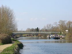
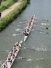
Donnington Bridge, seen from the south.Crosses River Thames Locale Oxford Designer Travers Morgan and Partners Design Arch Material Concrete Width 56 feet 8 inches (17.27 m) Height 16 feet 6 inches (5.03 m)[1] Longest span 170 feet (52 m) Number of spans 1 Opened 1962 Coordinates 51°44′08″N 1°14′31.5″W / 51.73556°N 1.242083°WCoordinates: 51°44′08″N 1°14′31.5″W / 51.73556°N 1.242083°W A view looking north from Donnington Bridge of a rowing bump at Eights Week (2005).
Donnington Bridge is a modern road bridge (completed in 1962) over the River Thames, in the south of the city of Oxford, England. At this point the river is sometimes called the Isis. The bridge carries the B4495 road (Donnington Bridge Road) from Abingdon Road to Iffley Road. It crosses the river on the reach between Iffley Lock and Osney Lock.
Contents
Design
Donnington Bridge has a single arch span of 170 feet between supports and an overall width of 56 feet 8 inches. It is constructed of reinforced concrete deck slab cast integrally with 10 pre-stressed concrete legs triangulated to meet the hinges enclosed within the abutments. The abutments are clad externally with pre cast concrete units faced with Criggion Green and Blue Shap stone and the facias of the bridge are calcined flint.
History
Early in 1954 Oxford city council revived a proposal to construct a new road to link Iffley Road and Abingdon Road which would cross the Thames near Donnington Lane. Various routes were considered and in December 1954 the present line was approved. Although the Minister of Transport refused to provide financial assistance, the council decided to proceed with the scheme.
The design and roadworks and the overall administration of the scheme were undertaken by the City engineer J Campbell Riddell. Travers Morgan and Partners were appointed as consultants for the design of the bridge itself and the backwater bridges.
As a result of a government credit squeeze, less than a week before contract documents were issued, the project had to be shelved until February 1960. The following June the contract in the sum of £309,903 16s 11d was awarded to the Cementation Company Ltd for the construction of the bridges and the new road and for the demolition of the free Ferry link foot bridge. The overall cost including improvements to the existing approach roads, street lighting, service diversions and landscaping, came to over £400,000.
Donnington Bridge was opened on the 22nd October 1962 by Viscount Hailsham who walked over the bridge. The Lord Mayor of Oxford, Evan Owen Roberts, was the first person to drive over the bridge.[2]
Activity
There is much rowing on the river by students of Oxford University, and members of the City of Oxford Rowing Club, and residents using the Riverside Centre, between Iffley Lock downstream from this bridge and Folly Bridge further upstream. The start of Eights Week and Torpids is just south of Donnington Bridge, and the bridge is a good place to view the races because of its high vantage point.
See also
- Crossings of the River Thames
- Christ Church Meadow
References
- ^ River Thames Alliance. Bridge heights on the River Thames.
- ^ Official Brochure of the Opening of Donnington bridge 22nd October 1962
Next crossing upstream River Thames Next crossing downstream Folly Bridge (road) Donnington Bridge Isis Bridge (road) Categories:- Bridges across the River Thames
- Bridges completed in 1962
- Bridges in Oxford
- Rowing in Oxford
- Thames Path
Wikimedia Foundation. 2010.

