- Interstate 195 (Maryland)
-
Interstate 195
Metropolitan Boulevard 
Route information Maintained by MDSHA Length: 4.71 mi[1][2] (7.58 km) Major junctions South end:  BWI Airport
 MD 170 in Linthicum
 MD 295 in Linthicum
 US 1 in Halethorpe
 I-95 in Arbutus
North end:  MD 166 in Arbutus
Highway system Auxiliary route of the Interstate Highway System
Main • Auxiliary • BusinessMaryland highway system
Interstate • US • State • Minor • Former • Turnpikes←  MD 194
MD 195  →
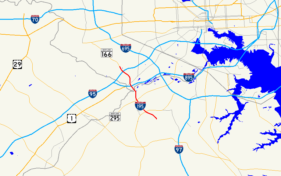
→Interstate 195 (I-195) is an Interstate highway in the U.S. state of Maryland. Known as Metropolitan Boulevard, the highway runs 4.71 mi (7.58 km) from Baltimore/Washington International Thurgood Marshall Airport (BWI Airport) in Linthicum north to I-95 in Arbutus, where Metropolitan Boulevard continues north as Maryland Route 166 (MD 166), which heads toward the University of Maryland, Baltimore County (UMBC) and Catonsville. I-195 is the main connection between the airport terminal and highways leading to Baltimore and Washington, including I-95 and MD 295. The Interstate highway also has an interchange with MD 170, which forms part of the Airport Loop that provides access to multiple airport-oriented parking lots, car rental facilities, hotels, cargo and general aviation facilities, and the BWI Rail Station. I-195 is a part of the National Highway System for its entire length.[3]
I-195 was constructed in three sections. The first section was a connection between MD 295 and the airport marked as MD 46 completed in 1951 shortly after the opening of the airport, which was originally named Friendship International Airport. The second segment was completed at the opposite end of the highway in the mid 1970s, connecting U.S. Route 1 (US 1) in Halethorpe and I-95 with MD 166 and UMBC. The first two segments were connected when the portion between MD 295 and US 1 was constructed in the late 1980s. The whole length of the highway was completed and received the I-195 designation in June 1990.
Contents
Route description
I-195 begins at the entrance to BWI Airport. The eastbound roadway continues southeast into the airport proper, where it features a left exit for the hourly parking garage and then splits into two roadways for arriving and departing flights. After the two roadways—arriving flights on the lower level and departing flights on the upper level—loop between the terminal and the hourly parking garage, the roadways merge. The westbound direction of I-195 heads northwest from the airport after it issues a ramp toward long-term parking and a U-turn toward the terminal.[4] I-195 heads northwest through Linthicum as a four-lane freeway, with a speed limit of 30 mph (48 km/h) between the airport and Exit 1 with MD 170 (Aviation Boulevard), also known as the Airport Loop, which the Interstate meets at a partial cloverleaf interchange.[1][4]
The speed limit increases to 60 mph (97 km/h) between the overpass for the BWI Trail and Exit 2 for MD 295 (Baltimore–Washington Parkway), which I-195 meets as a cloverleaf interchange with a flyover ramp from MD 295 south to I-195 east. The Interstate parallels the Amtrak Northeast Corridor and MARC's Penn Line before crossing the railroad tracks and the Patapsco River on a viaduct and entering Baltimore County.[1][4] I-195 crosses over I-895 (Harbor Tunnel Thruway) with no access before Exit 3 with US 1 (Washington Boulevard) in Halethorpe.[4]
I-195 continues northwest over CSX's Baltimore Terminal Subdivision toward its western terminus in Arbutus, which the highway reaches after Exit 4 with I-95. I-195 officially ends just beyond the ramps to and from I-95, where the speed limit drops to 50 mph (80 km/h) and the freeway continues as MD 166 under the Selford Road overpass. The freeway passes a partial interchange for UMBC Boulevard, which leads to the UMBC campus, before ending next to a park and ride facility at Rolling Road, on which MD 166 continues north toward Catonsville.[2][4] Eastbound I-195 is marked from the beginning of the eastbound roadway at Rolling Road.[4]
History
Friendship International Airport was constructed between 1947 and 1950 as the new primary airport for Baltimore.[5] To directly connect the airport with Baltimore, an access road was planned to link the new Baltimore–Washington Expressway, later designated MD 295, with the airport terminal. The first portion of the Friendship International Airport Access Road was completed between a full Y interchange at the expressway and MD 170 in October 1949 and designated MD 46.[6][7][8][9] The access road was completed from MD 170 to the airport terminal in July 1951, about the same time the expressway was completed between MD 46 and downtown Baltimore.[7][8]
The next section of present-day I-195 to be constructed was in Baltimore County. The first stretch of Metropolitan Boulevard, from US 1 northwest to approximately the Selford Road overpass, including the interchange with I-95, was constructed starting in 1969 and opened in August 1974.[10][8] The freeway was extended to its present terminus at Rolling Road and the ramps to UMBC Boulevard were constructed in 1975.[11] Metropolitan Boulevard has been signed as either another section of MD 46 or a southern extension of MD 166.[12][13]
The intermediate section between MD 295 and US 1 had been proposed since at least 1970, but construction did not get underway until 1987, when the highway's bridges over US 1 and I-895 were constructed.[14][15][16] The remainder of the highway from MD 295 to I-895 was completed, including reconstruction of the interchange with MD 295, and the intermediate section opened in June 1990.[8][17][18] The I-195 designation was applied to the highway's present length at the same time.[19] In 2002, as part of an expansion project at the airport, several new ramps were constructed to access parking lots and facilitate an easier U-turn for motorists leaving the terminal who wish to return to the terminal.[20][21]
Exit list
I-195 is marked as an east–west highway, even though exit numbers and mileposts start from the airport entrance in concordance with the MDSHA inventory.
County Location Mile
[1][2]Exit Destinations Notes Anne Arundel Linthicum 0.00 BWI AirportSouthern terminus 0.54 1 MD 170 (Aviation Boulevard) – Linthicum, OdentonSplit into exits 1A (north) and 1B (south) eastbound 1.61 2 MD 295 (Baltimore–Washington Parkway) – Baltimore, WashingtonSplit into exits 2A (north) and 2B (south) Baltimore Halethorpe 3.14 3 US 1 (Washington Boulevard) – ElkridgeArbutus 4.31 4 I-95 – Baltimore, WashingtonSplit into exits 4A (north) and 4B (south) 4.71 MD 166 north (Metropolitan Boulevard) – Catonsville, University of Maryland, Baltimore CountyNorthern terminus; freeway continues as MD 166 References
- ^ a b c d "Highway Location Reference: Anne Arundel County" (PDF). Maryland State Highway Administration. 2009. http://www.marylandroads.com/Location/2009_ARUNDEL.pdf. Retrieved 2010-09-12.
- ^ a b c "Highway Location Reference: Baltimore County" (PDF). Maryland State Highway Administration. 2009. http://www.marylandroads.com/Location/2009_BALTIMORE.pdf. Retrieved 2010-09-12.
- ^ Federal Highway Administration (August 2003) (PDF). National Highway System: Baltimore, MD (Map). http://www.fhwa.dot.gov/planning/nhs/maps/md/baltimore_md.pdf. Retrieved 2010-06-23.
- ^ a b c d e f Google, Inc. Google Maps – Interstate 195 (Map). Cartography by Google, Inc. http://maps.google.com/maps?f=d&source=s_d&saddr=Elm+Rd&daddr=I-195+W&geocode=FTzsVQIdKwNu-w%3BFVnEVgId33Jt-w&hl=en&mra=ls&sll=39.185537,-76.6761&sspn=0.00095,0.002411&ie=UTF8&t=h&z=13. Retrieved 2010-06-22.
- ^ "BWI Timeline". Maryland Aviation Administration. http://www.bwiairport.com/en/about-bwi/bwi-timeline. Retrieved 2010-06-23.
- ^ Report of the State Roads Commission of Maryland. 1949-1950. Baltimore: Maryland State Roads Commission. 1950-12-20. pp. 126–127. http://www.archive.org/details/reportofstateroa1949mary. Retrieved 2010-06-23.
- ^ a b Report of the State Roads Commission of Maryland. 1951-1952. Baltimore: Maryland State Roads Commission. 1952-12-15. pp. 41, 144. http://www.archive.org/details/reportofstateroa1951mary. Retrieved 2010-06-23.
- ^ a b c d "Major Transportation Milestones in the Baltimore Region Since 1940" (PDF). Baltimore Metropolitan Council. 2005-12-01. http://www.baltometro.org/reports/MajorTransMilestones.pdf. Retrieved 2010-04-30.
- ^ Maryland State Roads Commission (PDF). Map of Maryland (Map) (1950 ed.). http://commons.wikimedia.org/wiki/File:Maryland_State_Highway_Map_-_1950.pdf. Retrieved 2010-06-23.
- ^ "NBI Structure Number: 100000030266011". National Bridge Inventory. http://nationalbridges.com/nbi_record.php?StateCode=24&struct=100000030266011. Retrieved 2010-06-23.
- ^ "NBI Structure Number: 100000030291011". National Bridge Inventory. http://nationalbridges.com/nbi_record.php?StateCode=24&struct=100000030291011. Retrieved 2010-06-23.
- ^ "Traffic Volume Map" (PDF). Maryland State Highway Administration. 1980. http://www.marylandroads.com/Traffic_Volume_Maps/80_Traffic_Volume_Maps.pdf. Retrieved 2010-06-23.
- ^ "Traffic Volume Map" (PDF). Maryland State Highway Administration. 1986. http://www.marylandroads.com/Traffic_Volume_Maps/86_Traffic_Volume_Maps.pdf. Retrieved 2010-06-23.
- ^ Maryland State Roads Commission (PDF). Map of Maryland (Map) (1970 ed.). http://commons.wikimedia.org/wiki/File:Maryland_State_Highway_Map_-_1970.pdf. Retrieved 2010-06-23.
- ^ "NBI Structure Number: 100000030342013". National Bridge Inventory. http://nationalbridges.com/nbi_record.php?StateCode=24&struct=100000030342013. Retrieved 2010-06-23.
- ^ "NBI Structure Number: 100000030341013". National Bridge Inventory. http://nationalbridges.com/nbi_record.php?StateCode=24&struct=100000030341013. Retrieved 2010-06-23.
- ^ "NBI Structure Number: 100000020129013". National Bridge Inventory. http://nationalbridges.com/nbi_record.php?StateCode=24&struct=100000020129013. Retrieved 2010-06-23.
- ^ "NBI Structure Number: 100000020130013". National Bridge Inventory. http://nationalbridges.com/nbi_record.php?StateCode=24&struct=100000020130013. Retrieved 2010-06-23.
- ^ "Traffic Volume Map" (PDF). Maryland State Highway Administration. 1990. http://www.marylandroads.com/Traffic_Volume_Maps/90_Traffic_Volume_Maps.pdf. Retrieved 2010-06-23.
- ^ "NBI Structure Number: 300000AAMA18010". National Bridge Inventory. http://nationalbridges.com/nbi_record.php?StateCode=24&struct=300000AAMA18010. Retrieved 2010-06-23.
- ^ "Return loop off I-195 opens for BWI access". The Baltimore Sun (Baltimore: Tribune Company). 2002-11-04. http://articles.baltimoresun.com/2002-11-04/news/0211040040_1_return-loop-route-170-bwi. Retrieved 2010-06-23.
External links
Auxiliary routes of Interstate 95 Florida: 195 • 295 • 395 • 595 • 795 (future) — North Carolina: 295 (future) • 795 — Virginia: 195 • 295 • 395 • 495 • 595 (former) • 895 (proposed) — District of Columbia: 295 • 395 • 495 • 695 (unsigned) — Maryland: 195 • 295 • 395 • 495 • 595 (unsigned) • 695 • 795 • 895 — Delaware: 295 • 495 • 895 (former) — Pennsylvania: 195 (future) • 695 (unbuilt) • 895 (unbuilt) — New Jersey: 195 • 295 • 495 (former) • 695 (unbuilt) • 895 (unbuilt) — New York: 295 • 495 • 695 • 895 — Connecticut - Rhode Island - Massachusetts: 195 • 295 • 395 • 495 • 695 (unbuilt) • 895 (unbuilt) — Maine: 195 • 295 • 395 • 495 Categories:
- Three-digit Interstate Highways
- Interstate Highways in Maryland
- Interstate 95
- Baltimore-Washington International Thurgood Marshall Airport

Wikimedia Foundation. 2010.