- Maryland Route 713
-
Maryland Route 713

Route information Maintained by MDSHA Length: 3.05 mi[1] (4.91 km) Major junctions South end: Entrance to Fort Meade  MD 175 in Fort Meade
 MD 100 in Hanover
North end:  MD 176 in Hanover
Highway system Maryland highway system
Interstate • US • State • Minor • Former • Turnpikes←  MD 712
MD 715  →
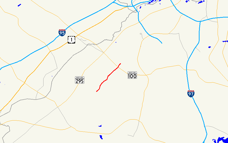
→Maryland Route 713 (MD 713) is a state highway in the U.S. state of Maryland. The state highway runs 3.05 mi (4.91 km) from an entrance to Fort George G. Meade north to MD 176 in Hanover. In addition to serving as an access point to the U.S. Army installation, MD 713 provides the primary access to the Arundel Mills regional shopping mall.
Contents
Route description
MD 713 begins just north of the Rockenbach Road entrance to Fort Meade.[1] The state highway heads north as a five-lane road with center turn lane to its intersection with MD 175 in the hamlet of Provinces.[2] MD 713 heads north from MD 175 as two-lane Ridge Road through residential subdivisions. At Stoney Run Drive, the state highway expands to a four-lane divided highway and enters a commercial area. MD 713 passes Ridge Chapel Road (MD 713B), part of the old alignment of MD 713, before reaching an intersection with Arundel Mills Boulevard, which heads southwest to an interchange with the Baltimore–Washington Parkway, and Arundel Way, an entrance to Arundel Mills.[1][2] MD 713 turns north onto Arundel Mills Boulevard, a six-lane divided highway, toward an interchange with MD 100 (Paul T. Pitcher Memorial Highway).[1] The state highway reaches its northern terminus just north of the MD 100 interchange at MD 176 (Dorsey Road). New Ridge Road continues straight as a county highway toward a collection of industrial and business parks in Hanover.[2]
Junction list
The entire route is in Anne Arundel County.
Location Mile
[1]Destinations Notes Fort Meade 0.00 Rockenbach Road south – Entrance to Fort Meade Southern terminus 0.49 MD 175 (Annapolis Road) – Jessup, OdentonHanover 2.37 Ridge Chapel Road east Old alignment of MD 713 2.48 Arundel Mills Boulevard south to  MD 295 (Baltimore–Washington Parkway) / Arundel Way west – Arundel Mills
MD 713 turns north onto Arundel Mills Boulevard 2.86 MD 100 (Paul T. Pitcher Memorial Highway) – Glen Burnie, Ellicott CityMD 100 Exit 10 3.05 MD 176 (Dorsey Road) – Harmans, BWI AirportNorthern terminus New Ridge Road north Auxiliary routes
MD 713 has five unsigned auxiliary routes and one former auxiliary route. MD 713A through 713E are associated with the construction of MD 100 through Hanover in the 1990s. MD 713F was assigned as part of the project to connect Arundel Mills Boulevard with the Baltimore–Washington Parkway.
- MD 713A was the designation for Clark Road, a 0.05-mile (0.080 km) connection between MD 713 south of Arundel Mills Boulevard and the county-maintained portion of Clark Road. MD 713A was removed from the state highway system in 2008.[1][3]
- MD 713B is the designation for Ridge Chapel Road, a 0.26-mile (0.42 km) connection between MD 713 south of Arundel Mills Boulevard and the county-maintained portion of Ridge Chapel Road. The road originally heads north, then turns east at the intersection with MD 713C. The first part of MD 713B is part of the old alignment of MD 713.[1][4]
- MD 713C is the designation for Teague Road, a 0.27-mile (0.43 km) section of the old alignment of MD 713 between MD 713B and a cul-de-sac adjacent to MD 100. The state highway provides access to Harmans Park, which contains Joe Cannon Stadium, a local baseball venue.[1][5]
- MD 713D is the designation for Ridge Road, a 0.15-mile (0.24 km) section of the old alignment of MD 713 between a dead end adjacent to MD 100 and MD 176.[1][6]
- MD 713E is the designation for Ridge Road, a 0.17-mile (0.27 km) section of the old alignment of MD 713 between MD 176 and a point north of New Ridge Road, immediately north of the northern terminus of MD 713D.[1][7]
- MD 713F is the designation for a 0.25-mile (0.40 km) section of Arundel Mills Boulevard through its dumbbell interchange with the Baltimore–Washington Parkway. MD 713F was assigned in 2002.[1][8][9]
References
- ^ a b c d e f g h i j k "Highway Location Reference: Anne Arundel County" (PDF). Maryland State Highway Administration. 2008. http://apps.roads.maryland.gov/KeepingCurrent/performTrafficStudies/dataAndStats/hwyLocationRef/2008_hlr_all/co02.pdf. Retrieved 2010-06-10.
- ^ a b c Google, Inc. Google Maps – Maryland Route 713 (Map). Google, Inc. http://maps.google.com/maps?f=d&source=s_d&saddr=Rockenbach+Rd&daddr=MD-713+N%2FArundel+Mills+Blvd&hl=en&geocode=FaACVQIdiPds-w%3BFdaLVQIdUmht-w&mra=ls&sll=39.16103,-76.694334&sspn=0.007603,0.01929&ie=UTF8&t=h&z=13. Retrieved 2010-06-10.
- ^ "Highway Location Reference: Anne Arundel County" (PDF). Maryland State Highway Administration. 2008. http://apps.roads.maryland.gov/KeepingCurrent/performTrafficStudies/dataAndStats/hwyLocationRef/2008_hlr_all/co02.pdf. Retrieved 2010-06-10.
- ^ Google, Inc. Google Maps – Maryland Route 713B (Map). Google, Inc. http://maps.google.com/maps?f=d&source=s_d&saddr=Teague+Rd&daddr=Ridge+Chapel+Rd&hl=en&geocode=FX5rVQIdQFdt-w%3BFc9sVQIdAmJt-w&mra=ls&sll=39.15255,-76.717006&sspn=0.000951,0.002411&ie=UTF8&t=h&z=18. Retrieved 2010-06-10.
- ^ Google, Inc. Google Maps – Maryland Route 713C (Map). Google, Inc. http://maps.google.com/maps?f=d&source=s_d&saddr=Ridge+Chapel+Rd&daddr=Teague+Rd&hl=en&geocode=FT5vVQIdhF5t-w%3BFfJ5VQIdMmpt-w&mra=ls&sll=39.156679,-76.716655&sspn=0.001901,0.004823&ie=UTF8&t=h&z=17. Retrieved 2010-06-10.
- ^ Google, Inc. Google Maps – Maryland Route 713D (Map). Google, Inc. http://maps.google.com/maps?f=d&source=s_d&saddr=Ridge+Rd&daddr=Ridge+Rd&hl=en&geocode=Ffx-VQIdkGtt-w%3BFVOFVQId7HFt-w&mra=ls&sll=39.159366,-76.716574&sspn=0.003802,0.009645&ie=UTF8&t=h&z=18. Retrieved 2010-06-10.
- ^ Google, Inc. Google Maps – Maryland Route 713E (Map). Google, Inc. http://maps.google.com/maps?f=d&source=s_d&saddr=Ridge+Rd&daddr=Ridge+Rd&hl=en&geocode=FTqGVQId6HJt-w%3BFUWWVQIdh3lt-w&mra=ls&sll=39.163345,-76.712181&sspn=0.00095,0.002411&ie=UTF8&t=h&z=16. Retrieved 2010-06-10.
- ^ "Highway Location Reference: Anne Arundel County" (PDF). Maryland State Highway Administration. 2008. http://apps.roads.maryland.gov/KeepingCurrent/performTrafficStudies/dataAndStats/hwyLocationRef/2008_hlr_all/co02.pdf. Retrieved 2010-06-10.
- ^ Google, Inc. Google Maps – Maryland Route 713F (Map). Google, Inc. http://maps.google.com/maps?f=d&source=s_d&saddr=Arundel+Mills+Blvd&daddr=Unknown+road&hl=en&geocode=FbF0VQId-Pxs-w%3BFaB7VQIddPFs-w&mra=ls&sll=39.155481,-76.744105&sspn=0.001901,0.004823&ie=UTF8&t=h&z=17. Retrieved 2010-06-10.
External links
Categories:- State highways in Maryland
- Roads in Anne Arundel County, Maryland

Wikimedia Foundation. 2010.