- Maryland Route 665
-
Maryland Route 665
Aris T. Allen Boulevard 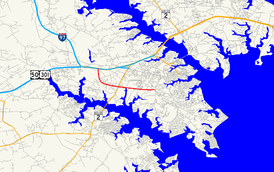
Route information Maintained by MDSHA Length: 2.68 mi[1] (4.31 km) Major junctions West end: 

 I-595 / US 50 / US 301 in Parole
 MD 2 in Annapolis
East end: Bywater Road in Annapolis Highway system Maryland highway system
Interstate • US • State • Minor • Former • Turnpikes←  MD 664
MD 667  →
→Maryland Route 665 (MD 665) is a state highway in the U.S. state of Maryland. Known as Aris T. Allen Boulevard, the state highway runs 2.68 mi (4.31 km) from unsigned Interstate 595 (I-595), U.S. Route 50, and US 301 in Parole east to Bywater Road and Forest Drive in Annapolis.
Contents
Route description
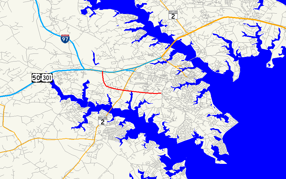
MD 665 begins at a directional interchange with unsigned I-595, US 50, and US 301 (John Hanson Highway) in Parole. The ramps from MD 665 tie into the ramps for I-97. The state highway heads southeast as a four-lane freeway toward a single-point urban interchange with Riva Road. MD 665 turns east and meets MD 2 (Solomons Island Road) at a partial cloverleaf interchange.[2] Beyond MD 2, the state highway crosses Church Creek and becomes a four-lane divided highway with partial access control. After an intersection with Chinquapin Round Road, MD 665 reaches its eastern terminus at Bywater Road.[1] The roadway continues southeast as Forest Drive toward the Bay Ridge area of Annapolis.[2]
Junction list
The entire route is in Anne Arundel County.
Location Mile
[1]Destinations Notes Parole 0.00  I-595 / US 50 / US 301 (John Hanson Highway) to I-97 – Washington, Bay Bridge, Baltimore, Richmond
Western terminus 0.93 Riva Road Single-point urban interchange 1.56 MD 2 (Solomons Island Road) – EdgewaterAnnapolis 2.55 Chinquapin Round Road north Unsigned MD 665C 2.68 Forest Drive east / Bywater Road south Eastern terminus References
- ^ a b c "Highway Location Reference: Anne Arundel County" (PDF). Maryland State Highway Administration. 2008. http://apps.roads.maryland.gov/KeepingCurrent/performTrafficStudies/dataAndStats/hwyLocationRef/2008_hlr_all/co02.pdf. Retrieved 2010-05-31.
- ^ a b Google, Inc. Google Maps – Maryland Route 665 (Map). Cartography by Google, Inc. http://maps.google.com/maps?f=d&source=s_d&saddr=Unknown+road&daddr=Forest+Dr&hl=en&geocode=FUrWUgIdcbdv-w%3BFZ6oUgIdYlpw-w&mra=ls&sll=38.97329,-76.521664&sspn=0.030495,0.077162&ie=UTF8&ll=38.977226,-76.543722&spn=0.030493,0.077162&t=h&z=14. Retrieved 2010-05-31.
External links
Categories:- State highways in Maryland
- Roads in Anne Arundel County, Maryland

Wikimedia Foundation. 2010.