- Maryland Route 372
-
Maryland Route 372
Wilkens Avenue 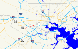
Maryland Route 372 highlighted in redRoute information Maintained by MDSHA and Baltimore DOT Length: 2.86 mi[1][2] (4.60 km) Major junctions West end:  MD 166 in Arbutus
 I-695 in Arbutus
East end:  US 1 in Baltimore
Highway system Maryland highway system
Interstate • US • State • Minor • Former • Turnpikes←  MD 371
MD 373  →
→Maryland Route 372 (MD 372) is a state highway in the U.S. state of Maryland. The state highway runs 2.86 mi (4.60 km) from MD 166 in Arbutus east to U.S. Route 1 (US 1) in Baltimore.
Contents
Route description
MD 372 begins at an intersection with MD 166 (Rolling Road) in Arbutus. The state highway heads north as Wilkens Avenue, a two-lane road. The route runs along the edge of Rolling Road Golf Course to the UMBC Roundabout, where the highway intersects Hilltop Road, which is one of the entrances to the campus of the University of Maryland, Baltimore County (UMBC).[1][3] After the roundabout, MD 372 expands to a four-lane divided highway and follows the edge of the UMBC campus.[1][3] The state highway curves to the east after passing Valley Road and meets I-695 (Baltimore Beltway). East of the Beltway, MD 372 crosses Maiden Choice Lane, where the highway reduces to a two-lane undivided highway, and Beechfield Avenue before entering the city of Baltimore.[1][2] The state highway runs alongside Loudon Park National Cemetery as a four-lane undivided street before meeting its eastern terminus at US 1, which continues toward downtown Baltimore as Wilkens Avenue and heads south as Southwestern Boulevard.[2][3] There is no access from northbound US 1 to westbound MD 372.[3]
Junction list
County Location Mile
[1][2]Destinations Notes Baltimore Arbutus 0.00  MD 166 (Rolling Road) to I-195 – Catonsville, BWI Airport
Western terminus 0.55 Hilltop Road – University of Maryland, Baltimore County UMBC Roundabout 1.41 I-695 (Baltimore Beltway) – Glen Burnie, TowsonBaltimore City 2.86 US 1 (Wilkens Avenue/Southwestern Boulevard) – Arbutus, Downtown BaltimoreEastern terminus; no access between northbound US 1 and westbound MD 372 References
- ^ a b c d e "Highway Location Reference: Baltimore County" (PDF). Maryland State Highway Administration. 2008. http://apps.roads.maryland.gov/KeepingCurrent/performTrafficStudies/dataAndStats/hwyLocationRef/2008_hlr_all/co03.pdf. Retrieved 2010-05-19.
- ^ a b c d "Highway Location Reference: Baltimore City" (PDF). Maryland State Highway Administration. 2005. http://apps.roads.maryland.gov/KeepingCurrent/performTrafficStudies/dataAndStats/hwyLocationRef/2005_hlr_all/co24.pdf. Retrieved 2010-05-19.
- ^ a b c d Google, Inc. Google Maps – Maryland Route 372 (Map). Cartography by Google, Inc. http://maps.google.com/maps?f=d&source=s_d&saddr=Wilkens+Ave&daddr=Wilkens+Ave&hl=en&geocode=FYDqVgIdxEZt-w%3BFdg3VwId9u1t-w&mra=ls&sll=39.270126,-76.681293&sspn=0.001898,0.004823&ie=UTF8&t=h&z=14. Retrieved 2010-05-19.
External links
Categories:- State highways in Maryland
- Roads in Baltimore County, Maryland
- Roads in Baltimore, Maryland


Wikimedia Foundation. 2010.