- Maryland Route 94
-
Maryland Route 94
Woodbine Road 
Route information Maintained by MDSHA Length: 6.25 mi[1] (10.06 km) Major junctions South end: Montgomery–Howard county line at Patuxent River 
 I-70 / US 40 in Lisbon
North end: Old Frederick Road near Lisbon Location Counties: Howard Highway system Maryland highway system
Interstate • US • State • Minor • Former • Turnpikes←  MD 93
MD 93I-95  →
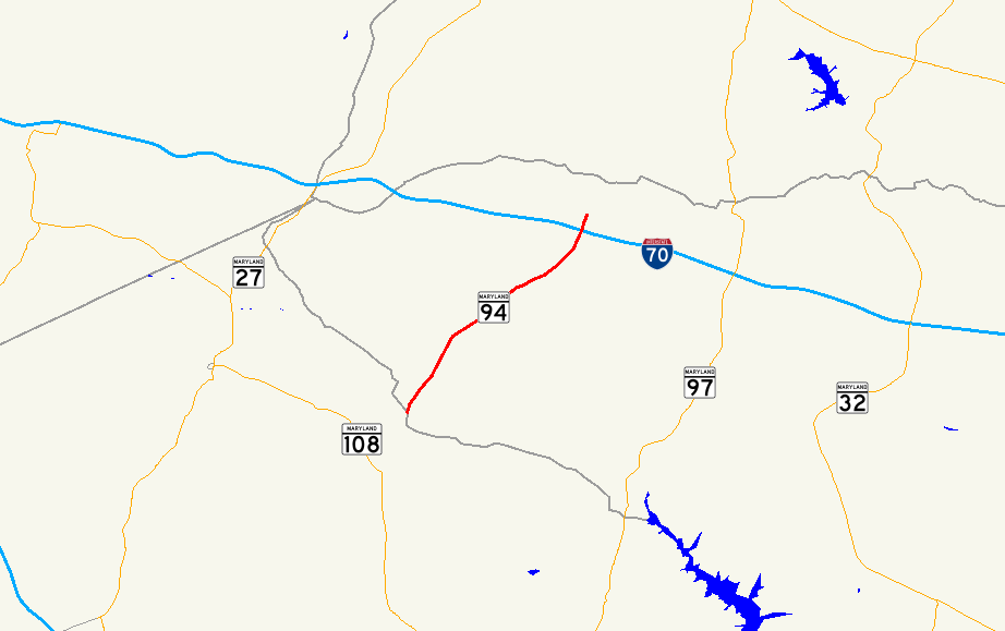
→Maryland Route 94 (MD 94) is a state highway in the U.S. state of Maryland. Known as Woodbine Road, the state highway runs 6.25 miles (10.06 km) from the Montgomery–Howard county line at the Patuxent River north to Old Frederick Road near Lisbon. MD 94 originally extended into southern Carroll County in addition to connecting the western Howard County communities of Lisbon and Florence. The state highway was constructed from Lisbon to Woodbine in the late 1910s. MD 94 was constructed from Lisbon south through Florence and from Woodbine north to the village of Daniel south of MD 26 in the late 1920s and early 1930s. The state highway was extended south and removed from the state highway system north of Lisbon in 1956. MD 94 was relocated when its interchange with Interstate 70 (I-70) and U.S. Route 40 (US 40) was built in the mid-1970s. The state highway has two roundabouts, one of which was the first modern roundabout in Maryland.
Contents
Route description
MD 94 begins at the Howard–Montgomery county line at a bridge over the Patuxent River. The highway continues south into Montgomery County as county-maintained Annapolis Rock Road, which intersects MD 108 (Damascus Road) east of Damascus. MD 94 passes through Patuxent River State Park as it ascends out of the narrow river valley and passes to the west of a steep hill named Annapolis Rock. The state highway crosses Cabin Branch and passes through the hamlet of Florence, where the highway intersects Florence Road; Florence Road leads east to the historic homes Cherry Grove and Hobson's Choice. MD 94 continues north through farmland to the village of Lisbon, where the highway meets MD 144 at a roundabout. The state highway meets I-70 and US 40 (Baltimore National Pike) at a diamond interchange before reaching its northern terminus at the Lisbon North Roundabout, where Woodbine Road meets Old Frederick Road. Woodbine Road continues north as a county highway to the village of Woodbine on the Patapsco River on the Howard–Carroll county line.[1][2]
History
The first section of MD 94 was built as a 14-foot (4.3 m) wide concrete road from Lisbon to Woodbine in 1916.[3] A concrete arch bridge across the Patapsco River at Woodbine was completed in 1917; a macadam road was constructed north 1 mile (1.6 km) into Carroll County by 1921.[3][4] Another section of MD 94 was constructed as a concrete road from Lisbon south to Florence in 1926 and 1927.[5][6] The macadam road in Carroll County was extended north 1 mile (1.6 km) to the hamlet of Day in 1928.[5][7] MD 94 in Carroll County was extended north in two sections from Day to the village of Daniel starting shortly after 1930; this macadam road was completed to near Buckhorn Road a short distance south of MD 26 in Winfield by 1933.[8][9] The concrete road through Florence was extended to just north of Cabin Creek in 1933.[9][10]
In 1956, MD 94's present termini were established. The state highway was extended from south of Florence to the Patuxent River; the highway was also transferred to county maintenance from Old Frederick Road north to Daniel. MD 94 was relocated to form a four-way intersection with MD 144 when its interchange with I-70 was constructed in 1974.[11] The state highway previously had a short concurrency with MD 144 in Lisbon between the road south to Florence and the highway north to Woodbine; the old alignment remains south of I-70 as Madison Street and north of the Interstate as Old Woodbine Road.[12] The first modern roundabout constructed in Maryland was completed at the intersection of MD 94 and MD 144 in 1993.[13][14] The roundabout with Old Frederick Road at the state highway's northern terminus was built in 1998.[14]
Junction list
The entire route is in Howard County.
Location Mile
[1]Destinations Notes 0.00 Annapolis Rock Road south to  MD 108 – Damascus
Southern terminus; Montgomery County line at Patuxent River Lisbon 5.45  MD 144 (Frederick Road) – Mount Airy, Cooksville
Roundabout 5.85 I-70 / US 40 (Baltimore National Pike) – Frederick, BaltimoreI-70 Exit 73 6.25 Old Frederick Road / Woodbine Road north – Woodbine Northern terminus; Lisbon North Roundabout 1.000 mi = 1.609 km; 1.000 km = 0.621 mi References
- ^ a b c "Highway Location Reference: Howard County" (PDF). Maryland State Highway Administration. 2009. http://www.marylandroads.com/Location/2009_HOWARD.pdf. Retrieved 2011-05-02.
- ^ Google, Inc. Google Maps – Maryland Route 94 (Map). Cartography by Google, Inc. http://maps.google.com/maps?f=d&source=s_d&saddr=MD-94+N%2FWoodbine+Rd&daddr=MD-94%2FWoodbine+Rd&geocode=FR5RVwIdmAVn-w%3BFSZmWAIdngNo-w&hl=en&mra=ls&sll=39.276783,-77.134334&sspn=0.001873,0.004823&ie=UTF8&t=h&z=12. Retrieved 2011-05-02.
- ^ a b Report of the State Roads Commission of Maryland. 1916-1919. Baltimore: Maryland State Roads Commission. January 1920. p. 27. http://www.archive.org/details/annualreportsofs1916mary. Retrieved 2011-05-02.
- ^ Maryland Geological Survey. Map of Maryland: Showing State Road System and State Aid Roads (Map) (1921 ed.).
- ^ a b Report of the State Roads Commission of Maryland. 1924-1926. Baltimore: Maryland State Roads Commission. January 1927. pp. 47. 51. http://www.archive.org/details/annualreportsofs1924mary. Retrieved 2011-05-02.
- ^ Maryland Geological Survey. Map of Maryland: Showing State Road System and State Aid Roads (Map) (1927 ed.).
- ^ Maryland Geological Survey. Map of Maryland: Showing State Road System and State Aid Roads (Map) (1928 ed.).
- ^ Report of the State Roads Commission of Maryland. 1927-1930. Baltimore: Maryland State Roads Commission. 1930-10-01. p. 203. http://www.archive.org/details/reportofstateroa1927mary. Retrieved 2011-05-02.
- ^ a b Maryland Geological Survey. Map of Maryland Showing State Road System: State Aid Roads and Improved County Road Connections (Map) (1933 ed.).
- ^ Report of the State Roads Commission of Maryland. 1931-1934. Baltimore: Maryland State Roads Commission. 1934-12-28. p. 340. http://www.archive.org/details/reportofstateroa1931mary. Retrieved 2011-05-02.
- ^ Maryland State Highway Administration. Maryland: Official Highway Map (Map) (1974 ed.).
- ^ Maryland State Roads Commission. Maryland: Official Highway Map (Map) (1961 ed.).
- ^ "Traveling Maryland's Roundabouts – History". Maryland State Highway Administration. http://www.sha.state.md.us/Index.aspx?PageId=285. Retrieved 2011-05-02.
- ^ a b Niederhauser, Mike (March 2002). "Modern Roundabouts in Maryland" (PDF). Maryland State Highway Administration. http://www.alaskaroundabouts.com/RABCHART4.pdf. Retrieved 2011-05-02.
External links
Roads in Howard County, Maryland State highways 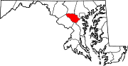
U.S. Highways Interstate Highways Categories:- State highways in Maryland
- Roads in Howard County, Maryland


Wikimedia Foundation. 2010.