- Maryland Route 104
-
Maryland Route 104
Waterloo Road 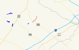
Route information Maintained by MDSHA Length: 1.14 mi[1] (1.83 km) Major junctions South end:  MD 108 near Columbia
 MD 100 near Columbia
North end:  MD 103 near Ellicott City
Location Counties: Howard Highway system Maryland highway system
Interstate • US • State • Minor • Former • Turnpikes← MD 103MD 107  →
→Maryland Route 104 (MD 104) is a state highway in the U.S. state of Maryland. Known as Waterloo Road, the state highway runs 1.14 miles (1.83 km) from MD 108 in Columbia north to MD 103 in Ellicott City. MD 104 connects MD 108, MD 103, and MD 100 in northeastern Howard County. The state highway was originally constructed as MD 531 in the early 1930s and became part of MD 175 in the mid-1940s. After MD 175 was rerouted through Columbia in the late 1970s, MD 104 was assigned to its present course.
Contents
Route description
MD 104 begins at a three-way intersection with MD 108 in the hamlet of Jonestown on the northern edge of the Columbia village of Long Reach. MD 108 heads southeast as a continuation of Waterloo Road toward Jessup and west as Old Annapolis Road, which provides access to Howard High School and ramps to and from eastbound MD 100. MD 104 heads north as a four-lane undivided highway across MD 100 to a roundabout where the state highway intersects ramps to and from westbound MD 100. MD 104 reduces to two lanes and passes through a suburban area on the southern edge of Ellicott City, where the highway reaches its northern terminus at MD 103 (Montgomery Road), which heads southeast toward Elkridge and northwest toward downtown Ellicott City.[1][2]
History
The original MD 104 followed Ilchester Road from MD 103 between Ellicott City and Elkridge north to the Patapsco River at Ilchester.[3] Ilchester Road was removed from the state highway system in 1956.[4] Waterloo Road was built as a macadam road in 1932 from U.S. Route 1 (US 1) in Jessup north to MD 103 in Ellicott City; the highway was designated MD 531.[3][5][6] MD 531 was replaced with a northern extension of MD 175 from Jessup to Ellicott City by 1946.[7] Old Annapolis Road was designated MD 539 in 1956; that highway became part of an extended MD 108 in 1960 when US 29 was moved to Columbia Pike from Silver Spring to Ellicott City.[4][8]
After MD 175 was rerouted along Little Patuxent Parkway (now named Rouse Parkway) from west of Interstate 95 to Columbia Town Center around 1977, MD 108 was extended east to its present terminus near I-95.[9] The portion of Waterloo Road between MD 108 and MD 103 was designated MD 104 by 1979.[10] When MD 100 was under construction between MD 104 and I-95 in the late 1990s, a standard intersection with MD 104 served as the eastern terminus of the two-lane, disjoint section of MD 100 between US 29 and MD 104.[11] MD 104's interchange with MD 100 was completed in 1998 concurrent with the portion of the freeway from MD 104 to I-95.[12][13]
Junction list
The entire route is in Howard County.
Location Mile
[1]Destinations Notes Columbia 0.00 MD 108 (Old Annapolis Road/Waterloo Road) to MD 100 east – Jessup, Glen BurnieSouthern terminus 0.16 MD 100 west – Ellicott CityRoundabout; MD 100 Exit 2 Ellicott City 1.14 MD 103 (Montgomery Road) – Downtown Ellicott City, ElkridgeNorthern terminus 1.000 mi = 1.609 km; 1.000 km = 0.621 mi Auxiliary route
MD 104A is the designation for the 0.16-mile (0.26 km) section of Oak Run Way between MD 104 and the residential subdivision the street serves immediately north of MD 104's interchange with MD 100.[1][14]
References
- ^ a b c d "Highway Location Reference: Howard County" (PDF). Maryland State Highway Administration. 2009. http://www.marylandroads.com/Location/2009_HOWARD.pdf. Retrieved 2011-05-03.
- ^ Google, Inc. Google Maps – Maryland Route 104 (Map). Cartography by Google, Inc. http://maps.google.com/maps?f=d&source=s_d&saddr=Waterloo+Rd&daddr=Waterloo+Rd&hl=en&geocode=FUh9VgId8AJs-w%3BFUCzVgIdqyhs-w&mra=ls&sll=39.23625,-76.797888&sspn=0.00349,0.009645&ie=UTF8&ll=39.228596,-76.797266&spn=0.027659,0.077162&t=h&z=14. Retrieved 2011-05-03.
- ^ a b Maryland State Roads Commission. General Highway Map: State of Maryland (Map) (1939 ed.).
- ^ a b Maryland State Roads Commission. Maryland: Official Highway Map (Map) (1956 ed.).
- ^ Report of the State Roads Commission of Maryland. 1931-1934. Baltimore: Maryland State Roads Commission. 1934-12-28. p. 340. http://www.archive.org/details/reportofstateroa1931mary. Retrieved 2011-05-03.
- ^ Maryland Geological Survey. Map of Maryland Showing State Road System: State Aid Roads and Improved County Road Connections (Map) (1933 ed.).
- ^ Maryland State Roads Commission. Maryland: Official Highway Map (Map) (1946-47 ed.).
- ^ Maryland State Roads Commission. Maryland: Official Highway Map (Map) (1960 ed.).
- ^ Maryland State Highway Administration. Maryland: Official Highway Map (Map) (1977 ed.).
- ^ Maryland State Highway Administration. Maryland: Official Highway Map (Map) (1979-80 ed.).
- ^ Maryland State Highway Administration. Maryland: Official Highway Map (Map) (1997 ed.).
- ^ "NBI Structure Number: 100000130148010". National Bridge Inventory. http://nationalbridges.com. Retrieved 2011-05-03.
- ^ Maryland State Highway Administration. Maryland: Official Highway Map (Map) (1999-2000 ed.).
- ^ Google, Inc. Google Maps – Maryland Route 104A (Map). Cartography by Google, Inc. http://maps.google.com/maps?f=d&source=s_d&saddr=Oak+Run+Way&daddr=Oak+Run+Way&hl=en&geocode=FVaIVgId6g1s-w%3BFb6IVgIdkARs-w&mra=ls&sll=39.226062,-76.805645&sspn=0.003457,0.009645&ie=UTF8&ll=39.226178,-76.805903&spn=0.003457,0.009645&t=h&z=17. Retrieved 2011-05-03.
External links
Roads in Howard County, Maryland State highways 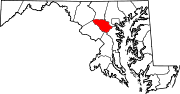
U.S. Highways Interstate Highways Categories:- State highways in Maryland
- Roads in Howard County, Maryland


Wikimedia Foundation. 2010.