- Maryland Route 28
-
Maryland Route 28
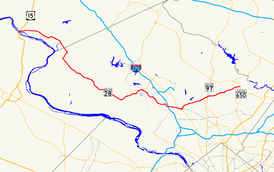
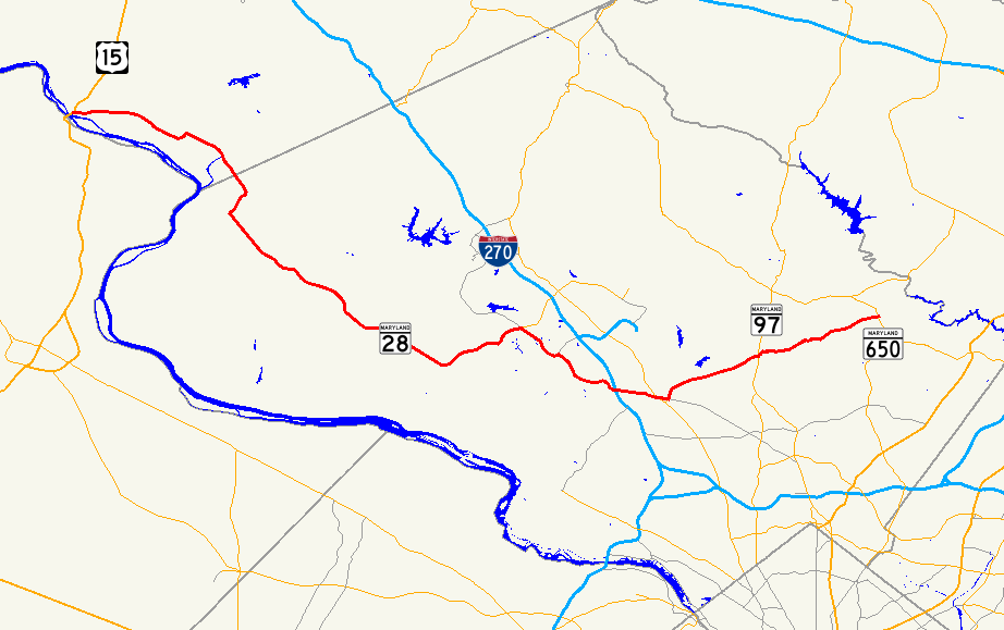
Maryland Route 28 highlighted in redRoute information Maintained by MDSHA Length: 37.38 mi[1][2] (60.16 km) Existed: 1927 – present Major junctions West end:  US 15 in Point of Rocks
 MD 85 in Tuscarora
 MD 109 in Beallsville
 MD 118 in Darnestown
 MD 124 in Gaithersburg
 MD 119 in Rockville
 I-270 in Rockville
 MD 355 in Rockville
 MD 586 in Rockville
 MD 115 in Norbeck
 MD 97 in Norbeck
 MD 200 in Norbeck (temporary)
East end:  MD 182 in Norwood
Highway system Maryland highway system
Interstate • US • State • Minor • Former • Turnpikes←  MD 27
MD 27US 29  →
→Maryland Route 28 (MD 28) is a state highway in the U.S. state of Maryland. The state highway runs 37.38 miles (60.16 km) from U.S. Route 15 (US 15) in Point of Rocks east to MD 182 in Norwood. The western portion of MD 28 is a rural highway connecting several villages in southern Frederick County and western Montgomery County. By contrast, the eastern portion of the state highway is a major east–west commuter route, particularly within Gaithersburg and Rockville.
MD 28 was an original 1927 Maryland state highway. The state highway originally extended north and east through Olney to Ashton, but the highway was rolled back to Norbeck in the 1940s. MD 28 was extended east to its present eastern terminus in the early 1980s. The original western terminus was in Tuscarora, but the state highway was extended to Point of Rocks around 1970. In addition to being expanded to a multi-lane divided highway in central Montgomery County beginning in the 1970s, MD 28 was relocated in downtown Rockville in the 1940s, in eastern Rockville in the 1970s, and in western Rockville in the 1990s.
Contents
Route description
MD 28 begins at an intersection with US 15 (Catoctin Mountain Highway) in Point of Rocks, just north of the Point of Rocks Bridge across the Potomac River.[3] The state highway heads east as Clay Street, a two-lane road with a speed limit of 30 mph (48 km/h), passing the Point of Rocks MARC station on the south before passing between two industrial facilities and crossing CSX's Old Main Line Subdivision.[1][3] MD 28 continues east as Tuscarora Road through farmland with a speed limit of 50 mph (80 km/h) after crossing Washington Run.[1] Turning southeast, the state highway crosses Tuscarora Creek and passes New Design Road.[3] The speed limit decreases to 35 mph (56 km/h) as MD 28 passes through the hamlet of Tuscarora before the roadway turns north and continues straight as MD 85 (Buckeystown Pike).[1][3] MD 28 turns right to continue on Dickerson Road.
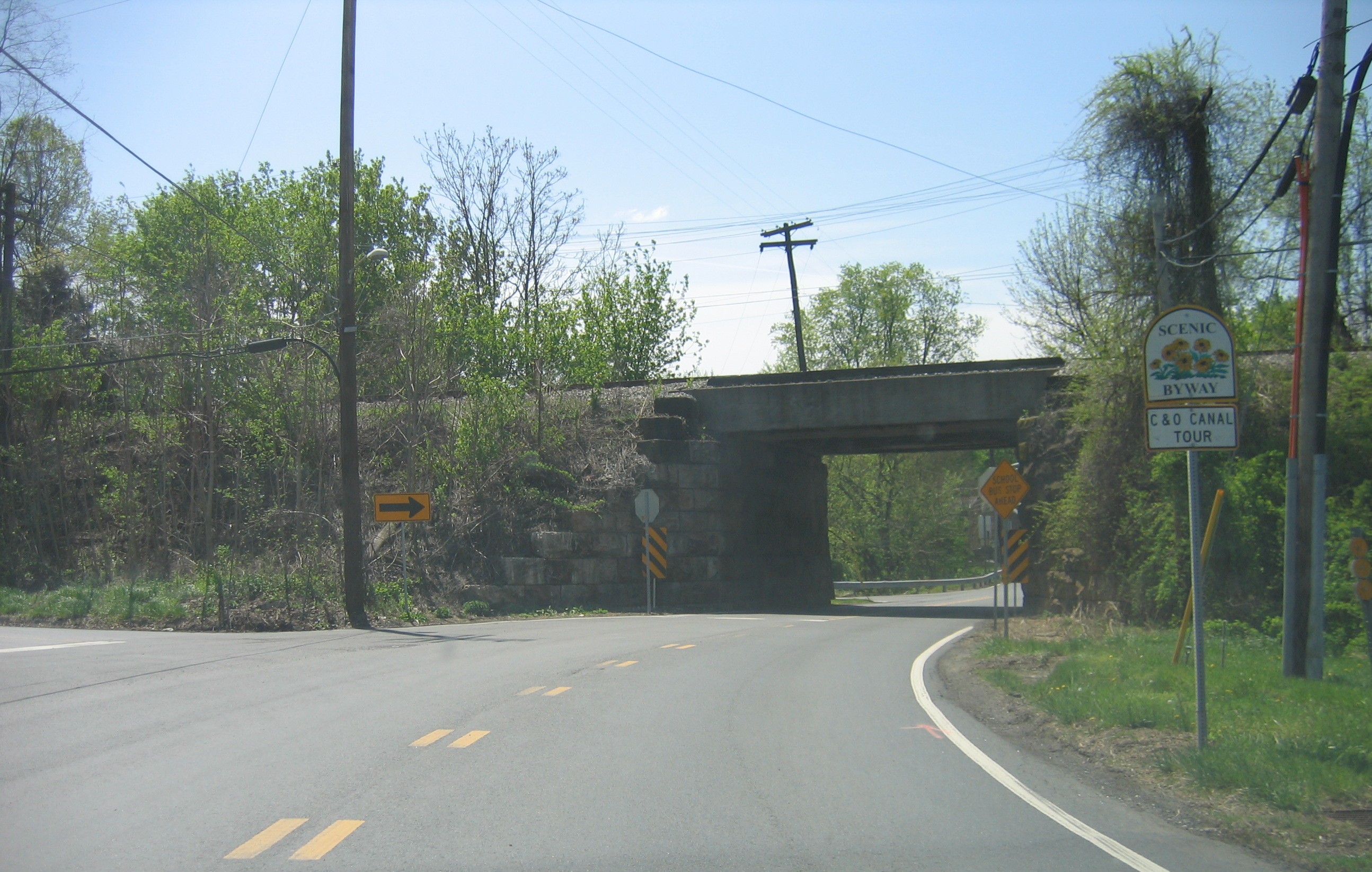
The speed limit returns to 50 mph (80 km/h) as MD 28 continues southeast, crossing the Monocacy River shortly before entering Montgomery County.[1] After intersecting Mouth of Monocacy Road, which heads west to the Monocacy Aqueduct, the speed limit drops to 30 mph (48 km/h) as the state highway enters Dickerson.[2][3] In Dickerson, MD 28 meets Mt. Ephraim Road, which serves the Dickerson MARC station and continues northeast toward Sugarloaf Mountain.[3] The state highway then turns south and passes through a narrow underpass of CSX's Metropolitan Subdivision and the MARC Brunswick Line.[3] MD 28 crosses the Little Monocacy River and the speed limit jumps to 50 mph (80 km/h) again before the intersection with Martinsburg Road, which heads southwest toward the Dickerson Generating Station and White's Ferry.[2][3]
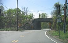 Intersection of MD 28 and Mt. Ephraim Road next to the underpass of CSX's Metropolitan Subdivision in Dickerson
MD 28 continues southeast as Darnestown Road through Beallsville, where the speed limit again temporarily drops to 30 mph (48 km/h).[2] After crossing MD 109 (Beallsville Road), MD 28 passes the Hanover Farm House at Four Streams Golf Club and crosses Dry Seneca Creek.[3] After an acute intersection with MD 117 (Bucklodge Road), the state highway enters Dawsonville, where it intersects White Grounds Road, which heads north past the Susanna Farm, and meets MD 107 (Whites Ferry Road) at a tangent intersection.[3] MD 28 crosses Seneca Creek and passes Seneca Creek State Park before entering Darnestown.[3] Within Darnestown, the speed limit drops to 30 mph (48 km/h) and the state highway intersects MD 118 (Germantown Road) and MD 112 (Seneca Road).[2] After MD 112, the speed limit increases to 40 mph (64 km/h) and MD 28 turns northeast and passes through residential subdivisions.[2][3] The state highway expands to a four-lane divided highway before passing Quince Orchard High School and intersecting MD 124 (Quince Orchard Road).[3]
MD 28 continues southeast along the southern edge of Gaithersburg, passing by the new urbanist development Kentlands and crossing Muddy Branch.[3] After the state highway expands to six lanes and intersects Muddy Branch Road, the old alignment of MD 28, Darnestown Road, splits to the east and MD 28 veers northeast as Key West Avenue.[2] After entering an area of office parks, the state highway intersects MD 119 (Great Seneca Highway).[3] MD 28 continues east and then southeast through the western part of Rockville, crossing Shady Grove Road before meeting Gude Drive, which provides a bypass of downtown Rockville.[3] After intersecting the other end of the old alignment of MD 28, the state highway changes its name to West Montgomery Avenue and crosses Watts Branch within the partial cloverleaf interchange with Interstate 270.[2][3]
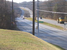 Looking west toward the crossing of Rock Creek from the intersection of MD 28 and Baltimore Road east of Rockville
MD 28 continues through the West Montgomery Avenue Historic District as a three-lane road with center turn lane with a speed limit of 30 mph (48 km/h).[2][3] At the intersection with Great Falls Road, the state highway veers to the southeast onto four-lane Jefferson Street through the Montgomery County Courthouse Historic District and passes the present government offices to the south.[3] MD 28 becomes a divided highway and veers east onto Veirs Mill Road before intersecting MD 355 (Rockville Pike) at an oblique intersection.[3] Left turns are prohibited from MD 28 to MD 355, so eastbound traffic must use Monroe Street to access MD 355 north. Westbound traffic can use Dodge Street, which is unsigned MD 660, to access MD 355 south. After MD 28 crosses the Metropolitan Branch and the Red Line of the Washington Metro, ramps to Stonestreet Avenue join eastbound and leave westbound to provide access to the Rockville Metro and MARC stations.[3] The state highway then meets MD 586 (Veirs Mill Road) and MD 911 (First Street). MD 28 turns north onto First Street at this intersection.
MD 28 heads north as a controlled-access four-lane divided highway through residential areas.[2][3] After intersecting Baltimore Road, the old alignment of MD 28, First Street continues straight and the state highway veers to the northeast as Norbeck Road with a speed limit of 50 mph (80 km/h).[2] MD 28 intersects the eastern end of Gude Drive, then crosses Rock Creek before meeting the other end of Baltimore Road.[3] The state highway continues east through suburban residential subdivisions, intersecting Bel Pre Road and gaining service roads at intervals.[3] After intersecting MD 115 (Muncaster Mill Road), MD 28 meets MD 97 (Georgia Avenue) in the unincorporated community of Norbeck and reduces to a two-lane road with a speed limit of 40 mph (64 km/h) through a forested area with scattered subdivisions.[2][3] The state highway crosses the future path of MD 200 (Intercounty Connector) near Wintergate Drive, where it intersects the temporary eastern terminus of the highway.[3] After crossing Batchellors Run, MD 28 expands to a four-lane divided highway for its terminating intersection with MD 182 (Layhill Road) in Norwood. Norbeck Road continues east as a county-maintained highway toward the intersection of MD 650 and MD 198 in Spencerville.[3]
History
One of the original state highways, MD 28 was marked and fully paved over its 1927 routing. The state highway's western terminus was the current intersection with MD 85 in Tuscarora; US 15 headed both west and north from there. MD 28 continued east along roughly its same alignment to MD 97 in Norbeck. At Norbeck, MD 28 became concurrent with MD 97 to Olney, then headed east along the route of current MD 108 to what was then MD 27 (which later became US 29 and is now MD 650) in Ashton.[4] The stretch of highway between MD 97 and MD 182, which was paved by 1935, was marked as MD 609 by 1939.[5][6]
MD 28 originally followed Baltimore Road between downtown Rockville and east of Rock Creek.[7] Between 1940 and 1944, MD 28 was placed on a new grade-separated crossing of the Metropolitan Branch along Veirs Mill Road, then north on First Street to Baltimore Road.[8] MD 28 was rolled back from Ashton to Norbeck between 1944 and 1946.[9] In 1969 or 1970, the controlled access portion of US 15 north of Point of Rocks was completed.[10][11] As a result, MD 85 was assigned to the old route of US 15 north of Tuscarora and MD 28 was extended west to its current terminus in Point of Rocks.[11] Also in 1970, the bypass of Baltimore Road in eastern Rockville was under construction.[10][11] In 1981, MD 28 was made a divided highway between downtown Rockville and Baltimore Avenue west of Rock Creek.[12] In 1982, the divided highway was extended from Baltimore Avenue east of Rock Creek to MD 97.[13]
In the mid 1990s, Key West Avenue in the western part of Rockville was completed and expanded to a six-lane divided highway. MD 28 was moved to the improved highway to bypass the parallel stretch of Darnestown Road by 1999.[14] Between 2002 and 2004, MD 28 was widened to a four- to six-lane divided highway between MD 124 and the west end of Key West Avenue.[15][16] In 2002, Norbeck Road was completed between the eastern terminus of MD 28 and the MD 650-MD 198 intersection.[15] While this highway was originally planned to become an extension of MD 28, eventually Montgomery County retained control of the highway.[17]
Junction list
County Location Mile
[1][2]Destinations Notes Frederick 9.36 miles (15.06 km)
Point of Rocks 0.00 US 15 (Catoctin Mountain Highway) – Frederick, LeesburgWestern terminus Tuscarora 4.73 MD 85 north (Buckeystown Pike) – Buckeystown, FrederickMD 28 turns east at intersection Montgomery 29.88 miles (48.09 km)
Dickerson 8.41 Mt. Ephraim Road north – Comus Former MD 419 9.60 Martinsburg Road south – White's Ferry Former MD 419 Beallsville 11.85 MD 109 (Buckeystown Pike) – Poolesville, BarnesvilleDawsonville 15.43  MD 117 east (Bucklodge Road) – Boyds
17.07 White Grounds Road north – Boyds Former MD 121 17.31  MD 107 west (Whites Ferry Road) – Poolesville
Darnestown 19.93 MD 118 north (Germantown Road) – Germantown20.68  MD 112 south (Seneca Road) – Seneca
Gaithersburg 23.20 MD 124 north (Quince Orchard Road) – Montgomery Village, North Potomac25.27 Muddy Branch Road – Gaithersburg, North Potomac Rockville 25.69 Darnestown Road east Old alignment of MD 28 26.12 MD 119 north (Great Seneca Highway) – Gaithersburg, Germantown27.01 Shady Grove Road – Shady Grove 27.41 Gude Drive east – Derwood 27.92 Darnestown Road west Old alignment of MD 28 28.65 I-270 (Eisenhower Memorial Highway) – Frederick, WashingtonI-270 Interchange 6 29.55 Great Falls Road south to  MD 189 – Potomac
30.22 MD 355 (Rockville Pike) – Gaithersburg, North Bethesda30.33 Dodge Street Unsigned MD 660 30.55 Stonestreet Avenue north Westbound exit, eastbound entrance 30.65  MD 586 east (Veirs Mill Road) / MD 911 south (First Street) – Wheaton, North Bethesda
MD 28 turns north at intersection 31.00 Baltimore Road east Old alignment of MD 28 31.59 Gude Drive west – Derwood 32.54 Baltimore Road west Old alignment of MD 28 Norbeck 34.59 MD 115 west (Muncaster Mill Road) – Redland, Montgomery Village34.81 MD 97 (Georgia Avenue) – Glenmont, Olney35.72 MD 200 (Intercounty Connector)Temporary junction, ramps to be removed upon further eastward ICC completion. Norwood 37.38 MD 182 (Layhill Road) / Norbeck Road east – Glenmont, Sandy Spring, SpencervilleEastern terminus 1.000 mi = 1.609 km; 1.000 km = 0.621 mi
Concurrency terminus • Closed/Former • Incomplete access • UnopenedReferences
- ^ a b c d e f "Highway Location Reference: Frederick County" (PDF). Maryland State Highway Administration. 2008. http://apps.roads.maryland.gov/KeepingCurrent/performTrafficStudies/dataAndStats/hwyLocationRef/2008_hlr_all/co10.pdf. Retrieved 2010-02-15.
- ^ a b c d e f g h i j k l m "Highway Location Reference: Montgomery County" (PDF). Maryland State Highway Administration. 2008. http://apps.roads.maryland.gov/KeepingCurrent/performTrafficStudies/dataAndStats/hwyLocationRef/2008_hlr_all/co15.pdf. Retrieved 2010-02-15.
- ^ a b c d e f g h i j k l m n o p q r s t u v w x y z aa Google, Inc. Google Maps – Maryland Route 28 (Map). Cartography by Google, Inc. http://maps.google.com/maps?f=d&source=s_d&saddr=us+15+and+md-28+point+of+rocks,+md&daddr=md-28+and+md-119+rockville,+md+to:md-28+and+md-182+colesville,+md+20905&hl=en&geocode=FfBIVwIdI85g-yn_M6sqNCC2iTEvnIDHFFQZrg%3BFTarVAIdxe1l-yl51Q5grzK2iTHuok5KIpegNw%3BFaHuVAIdx45o-yndf_KkQtC3iTEKP29h9qP2Sg&mra=ls&sll=39.095164,-77.105999&sspn=0.060884,0.154324&ie=UTF8&t=h&z=11. Retrieved 2010-02-17.
- ^ Maryland State Roads Commission (JPG). Map of Maryland (Map) (1927 ed.). http://www.mdhighwaycentennial.com/images/template/gallery/maps/1927SIDE1.jpg. Retrieved 2010-02-17.
- ^ Maryland State Roads Commission (PDF). Map of Maryland (Map) (1935 ed.). http://commons.wikimedia.org/wiki/File:Maryland_State_Highway_Map_-_1935.pdf. Retrieved 2010-02-17.
- ^ Maryland State Roads Commission (PDF). Map of Maryland (Map) (1939 ed.). http://commons.wikimedia.org/wiki/File:Maryland_State_Highway_Map_-_1939.pdf. Retrieved 2010-02-17.
- ^ Maryland State Roads Commission (PDF). Map of Maryland (Map) (1940 ed.). http://commons.wikimedia.org/wiki/File:Maryland_State_Highway_Map_-_1940.pdf. Retrieved 2010-02-17.
- ^ United States Geological Survey. Rockville quadrangle (Map). 1:48,000. 15 Minute Series (Topographic) (1944 ed.). http://historical.mytopo.com/quad.cfm?quadname=Rockville&state=MD&series=15. Retrieved 2010-02-17.
- ^ Maryland State Roads Commission (PDF). Map of Maryland (Map) (1946 ed.). http://commons.wikimedia.org/wiki/File:Maryland_State_Highway_Map_-_1946.pdf. Retrieved 2010-02-17.
- ^ a b Svirsky, Alexander. "National Bridge Inventory Database". http://nationalbridges.com/. Retrieved 2010-02-17.
- ^ a b c Maryland State Roads Commission (PDF). Map of Maryland (Map) (1970 ed.). http://commons.wikimedia.org/wiki/File:Maryland_State_Highway_Map_-_1970.pdf. Retrieved 2010-02-17.
- ^ "Traffic Volume Map" (PDF). Maryland State Highway Administration. 1981. http://www.marylandroads.com/Traffic_Volume_Maps/81_Traffic_Volume_Maps.pdf. Retrieved 2010-02-17.
- ^ "Traffic Volume Map" (PDF). Maryland State Highway Administration. 1982. http://www.marylandroads.com/Traffic_Volume_Maps/82_Traffic_Volume_Maps.pdf. Retrieved 2010-02-17.
- ^ "Highway Location Reference: Montgomery County" (PDF). Maryland State Highway Administration. 1999. http://apps.roads.maryland.gov/KeepingCurrent/performTrafficStudies/dataAndStats/hwyLocationRef/Allint_99_hlr/co15.pdf. Retrieved 2010-02-17.
- ^ a b "Highway Location Reference: Montgomery County" (PDF). Maryland State Highway Administration. 2002. http://apps.roads.maryland.gov/KeepingCurrent/performTrafficStudies/dataAndStats/hwyLocationRef/2002_hlr_all/co15.pdf. Retrieved 2010-02-17.
- ^ "Highway Location Reference: Montgomery County" (PDF). Maryland State Highway Administration. 2004. http://apps.roads.maryland.gov/KeepingCurrent/performTrafficStudies/dataAndStats/hwyLocationRef/2004_hlr_all/co15.pdf. Retrieved 2010-02-17.
- ^ "Highway Location Reference: Montgomery County" (PDF). Maryland State Highway Administration. 2001. http://apps.roads.maryland.gov/KeepingCurrent/performTrafficStudies/dataAndStats/hwyLocationRef/2001_hlr_all/co15.pdf. Retrieved 2010-02-17.
External links
Roads in Montgomery County, Maryland Maryland State Highways 
U.S. Routes Interstate Highways Roads by name Cabin John Parkway · Clara Barton Parkway · Cherry Hill Road · Connecticut Avenue · Georgia Avenue · Montrose Road · New Hampshire Avenue · Randolph Road · Sligo Creek Parkway · Wisconsin Avenue · 16th StreetCategories:- State highways in Maryland
- Roads in Frederick County, Maryland
- Roads in Montgomery County, Maryland


Wikimedia Foundation. 2010.