- Old Main Line Subdivision
-
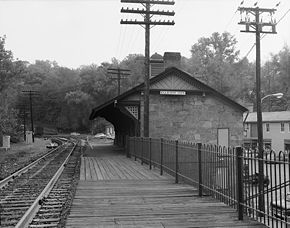 Ellicott City Station, built 1830, is the oldest surviving passenger station in the United States. Photo taken in 1970, looking south towards Baltimore.
Old Main Line in 1917 Legend
Baltimore Terminal Subdivision 

0.0 Relay (Washington Branch) 
2.5 Orange Grove 
3.2 Ilchester Tunnel 
3.5 Ilchester Bridge 3.6 Ilchester 4.4 Lees 4.7 Gray 5.7 Ellicott City 6.2 Sucker Run Bridge 7.9 Union Dam Tunnel 

9.2 HS Tower 9.5 Hollofield 10.6 Daniels Bridge 10.9 Alberton 11.6 Brice Run Bridge 12.1 Dorsey’s Run Tunnel 12.7 Eureka Bridge 12.8 Line Run Bridge 12.9 Davis Tunnel 13.3 Davis 13.8 Davis Branch Bridge 14.6 Woodstock 17.1 Marriottsville 17.7 Henryton Bridge 17.8 Henryton Tunnel 17.9 Henryton 19.7 Gorsuch 21.6 Sykesville 22.4 Sykesville Tunnel 22.9 Gaither 24.2 Hood’s Mill 26.1 Morgan 26.5 Woodbine Tunnel 26.8 Woodbine 26.9 Gillis Falls Bridge 29.5 Watersville 


30.6 Watersville Jct 1.8 Mount Airy 32.6 Mount Airy Tunnel 

33.9 Mount Airy Jct 37.4 Bush Creek Bridge 39.5 Monrovia 40.0 Monrovia Tower 42.9 Ijamsville 44.1 Hartman Tunnel 46.1 Reel’s Mill 47.4 Monocacy River Bridge 47.5 Frederick Jct (Frederick Branch) 
3.5 Frederick (S. Market St.) 48.9 Ballenger Creek Bridge 50.0 Lime Kiln 51.7 Buckeystown 53.7 Adamstown 
53.9 Adamstown Jct Adamstown Cutoff 

58.0 Washington Jct (Point of Rocks) (Metropolitan Branch) 58.5 Point of Rocks Tunnel 60.1 Catoctin Tunnel 
To Brunswick The Old Main Line Subdivision is a railroad line owned and operated by CSX Transportation in the U.S. state of Maryland. The line runs from Relay (outside Baltimore) west to Point of Rocks, and was once the main line of the Baltimore and Ohio Railroad, one of the oldest rail lines in the United States. At its east end, it has junctions with the Capital Subdivision and the Baltimore Terminal Subdivision; its west end has a junction with the Metropolitan Subdivision.
Contents
History
The initial route of the Baltimore and Ohio Railroad (B&O) followed the Patapsco River valley west out of Baltimore, with the first section (to what is now Ellicott City, Maryland) opening for service in 1830.[1]:21 The line left the valley to cross Parr's Ridge, which, after an abortive attempt to use a system of inclined planes, was crossed via a more round-about routing through Mount Airy. It continued west to Harper's Ferry, West Virginia, passing south of Frederick on the way. This line was the only route west out of Baltimore until the Metropolitan Branch was constructed from Washington, DC to Point of Rocks in the 1870s. The section of the original route from Relay (where the Washington Branch began) to Point of Rocks became known as the "Old Main Line" (or "OML" for short) as it was relegated to secondary status, and continues to known as the Old Main Line Subdivision in CSX timetables.
Initial improvements
Since railroad technology was in its infancy, the engineers of the B&O made many design decisions which quickly proved to be mistaken. The route was laid out to minimize grades at the expense of curvature; elimination of the resulting sharp curves led to the construction of many tunnels over the next century. The planes over Parr's Ridge arose from the same decision, and they gained the distinction of becoming one of the first railroad main line right-of-way abandonments in history.
Initially a system of granite stringers and strap rail was preferred, although time, expense, and difficulty in obtaining sufficient granite led to the substitution of wooden ties and heavier "T-rails" for much of the route, beginning in the 1840s.[1]:39 In the 1850s, when Benjamin Latrobe was chief operating engineer, the need to address these deficiencies became acute, and a variety of improvements were made, subject to the railroad's limited resources at the time. All of the granite stringers and strap rail were replaced, and certain realignments were made. Among these was the "Elysville cutoff", where a pair of bridges were constructed to bypass a sharp curve on the south side of the river. In making these improvements, older structures were simply abandoned. The granite stringers of the original roadbed were simply left in place and buried.
B&O built its first tunnel in 1850 at Henryton. The Henryton Tunnel was widened for double track in 1865, after the Civil War.[1]:47, 452
The flood of 1868
In 1868 a freak storm flooded the Patapsco and severely damaged the railroad, as well as washing away many of its customers. Most of the railroad was rebuilt, but with many alterations to the surviving structures. For instance, all but one arch of the Patterson Viaduct at Ilchester were washed away; the railroad retained the remaining arch to use as an abutment for the Bollman truss bridge which replaced the viaduct.
Station building
The first station on the line was built in Ellicott City in 1830, Over the years this station was modified and enlarged, and it survives to this day. The next station erected was a freight depot in Frederick, built 1831. Another simple station was built in Mt. Airy, which also survives.
In the 1870s and 1880s, the railroad undertook a program of station building. Most of these were designed by E. Francis Baldwin and several towns on the Old Main Line received such stations, erected in either wood or brick. The most famous of these, at Point of Rocks, still stands in the wye between the OML and the Metropolitan Subdivision. Other stations were built at Sykesville, Ilchester, and Woodstock, though not all survive.
Improvements under Leonor F. Loree
In 1901 Leonor F. Loree was installed as president of the railroad. Among other projects, he initiated a reassessment of the Old Main Line which led to a project of systematic improvements. Much of the original route and many reroutings were abandoned in favor of new routes along the valley. Many new tunnels were cut, and new bridges were built along new alignments. In particular the Mt. Airy Cutoff tunnelled through Parr's Ridge and reduced the old line through Mt. Airy to a spur. (Ironically the west end of the spur met the main line at the base of Plane 3, the middle of the western half of the original inclined plane system.) B&O maintained the spur as a loop until 1957, when the eastern end was abandoned.[1]:174 [2]
At the west end of the line, the Adamstown Cutoff was built to allow operation of coal drags over the OML, minimizing the use of helpers. A water and coaling stop was added at Reels Mill to support this. In practice the operation was not successful, and the cutoff was discontinued, though it was not pulled up for decades.
Decline and Agnes
Following the opening of the Metropolitan Branch in 1873, the B&O routed its through passenger trains via Washington, and passenger service on the OML became strictly local. By 1928, only three passenger trains left Baltimore on the OML each day.[1]:160-162 The area lacked industry, and the granite mines at the east end of the valley did not last. Therefore service declined steadily. During World War II, however, traffic rose dramatically, and a new water and coal station was added at Gaither to allow engines to be serviced outside the congestion of Baltimore City. The facilities were closed shortly after the end of the war, and all passenger service ended soon after. In 1959 the line was reduced to single track to increase the clearance through the tunnels, and Centralized Traffic Control (CTC) was introduced.[1]:174
In 1972 Hurricane Agnes flooded the valley again, washing out large portions of the line. The B&O considered abandoning the line, and several years passed before service was restored. For many years much of the line remained dark (i.e. operating without signals), but eventually the entire line was re-signalled.
MARC service
The MARC commuter rail system originally did not serve any portion of the OML, though there was always service over the oldest portion of the line into Baltimore and from Point of Rocks to Washington. In the late 1990s, however, commuter traffic to Washington from Frederick had grown substantially, and MARC service between the two cities was initiated. The existing wye which connected the two lines at Point of Rocks station was upgraded to take through traffic, and trains were thus able to follow the OML up to Frederick Junction and then into town. This service remains the only scheduled passenger operation over the OML.
Archaeology
After the initial push, the builders of the OML tended to prefer very permanent materials--stone and iron-- over the wooden structures used elsewhere. And since much of the river valley became part of the Patapsco Valley State Park, the area along the line contains an uncommonly large range of early 19th century railroad artifacts and structures, readily accessible to the railfan. In many places even the granite stringers of the original roadbed can be seen.
Some of the more notable relics are:
- The remains of the Patterson Viaduct at Ilchester (where the foundation of the demolished Ilchester station can also be seen)
- The station in Ellicott City (now a museum)
- The remains of the Elysville bridges at Daniels
- The Sykesville station (used as the prototype for a well-known HO scale model)
- The original Twin Arch Bridge on the Mt. Airy planes alignment
- The station and junction at Point of Rocks
See also
References
- Dilts, James D. (1996), The Great Road: The Building of the Baltimore and Ohio, the Nation's First Railroad, 1828-1853, Palo Alto, CA: Stanford University Press, ISBN 978-0804726290
External links
- Steve Okonski's B&O RR Photo Tours has extensive photos and maps of OML right-of-way and relics
- Patapsco Valley State Park
Categories:- Baltimore and Ohio Railroad lines
- CSX Transportation lines
- Rail infrastructure in Maryland

Wikimedia Foundation. 2010.