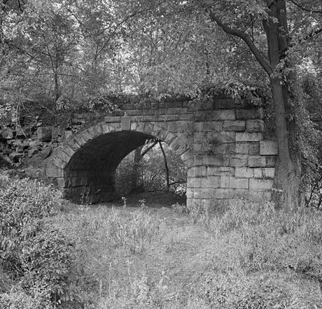
- Patterson Viaduct
Infobox_Bridge
bridge_name =Patterson Viaduct
caption = Patterson Viaduct Ruins, 1970
official_name = Patterson Viaduct
crosses =Patapsco River
(before 1868)
locale =Ilchester, Maryland
design =Arch bridge
mainspan = 55 feet (17 m)
length = 360 feet (110 m)
below = 43 feet (13 m)
open = December of 1829
closed = 1868
coordinates=Coord|39|14|56|N|76|45|53|W|type:landmark_region:US|display=inlineThe Patterson Viaduct, heavily damaged by a flood in 1868, spanned thePatapsco River atIlchester, Maryland . Built from May to December 1829, theviaduct was part of the original main line of theBaltimore and Ohio Railroad . It was constructed in the first building phase of the railroad, which extended fromBaltimore, Maryland to Ellicott's Mills. The Patterson, the third bridge built for the Baltimore and Ohio, was similar in construction to theCarrollton Viaduct . Designed by Caspar Wever, it was built under the supervision of John McCartney, one of his assistants. McCartney received the contract to build theThomas Viaduct as a result of his successful completion of the Patterson contract.The remains of the Patterson Viaduct stand on the east and west banks of the
Patapsco River just south of the present railroad bridge. The bridge rose about 43 feet (13 m) above its foundations. It had four graduated arches — two of 55 feet chord (17 m) each and two of 20 feet (6 m) chord each. The smaller arches were introduced for the accommodation of two county roadways, one on each side of the river. The viaduct, constructed of granite blocks, was approximately 360 feet (110 m) in length. The exterior surfaces of the granite blocks were undressed, or rusticated.
The viaduct was almost totally destroyed in the great Patapsco Valley flood of 1868. A single-span Bollman Truss built into the west abutment in 1869 incorporated the original roadway arch and upstream wingwall. The Bollman design was supplanted by another bridge before the railroad was realigned about 400 feet (120 m) upstream in 1902–1903 with the opening of the Illchester Tunnel. Today, all that remains at the original crossing is the single masonry roadway arch of the 1829 construction on the west bank and the stone abutment on the east bank. In 2006 a cable-stayed footbridge with a design that echoes a Bollman Bridge was added atop the abutments.The Patterson Viaduct Ruins were listed on the
National Register of Historic Places onJune 3 ,1976 .External links
* Maryland Historical Trust: [http://www.marylandhistoricaltrust.net/nr/NRTourDetail1.aspx National Register Bridge Tour - Patterson Viaduct] . Link is a Javascript tour of Maryland bridges on the National Register. Please use the links to find the page about the Patterson Viaduct.
Wikimedia Foundation. 2010.
