- Monocacy River
-
For other streams named Monocacy, see Monocacy (disambiguation).
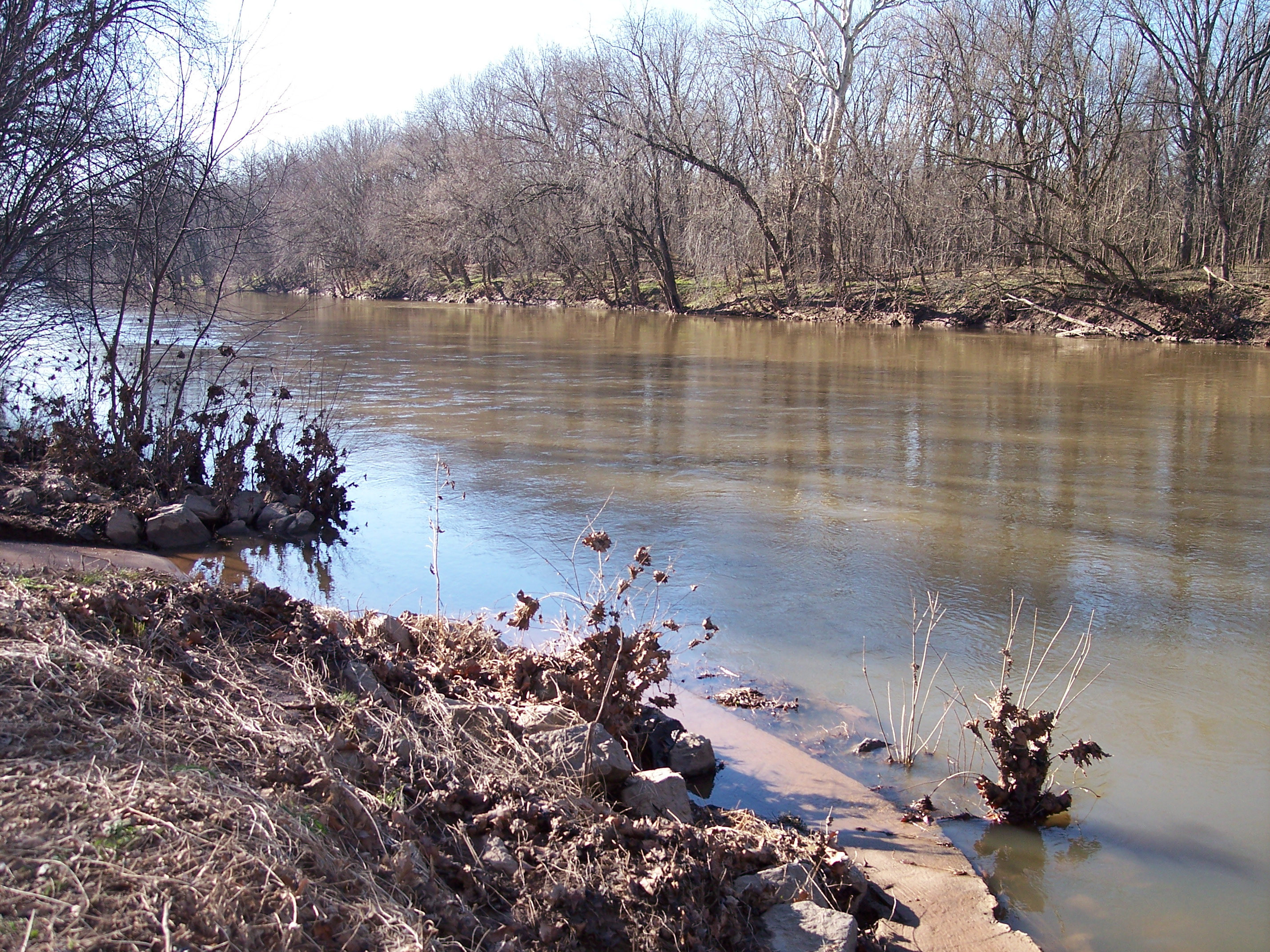
Monocacy River 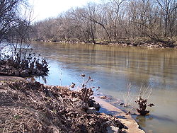 The Monocacy River near Frederick in 2007
Country United States State Maryland Tributaries - left Piney Creek, Double Pipe Creek, Israel Creek, Linganore Creek, Furnace Branch - right Toms Creek, Tuscarora Creek, Carroll Creek, Ballenger Creek City Frederick Source - location Harney, Carroll County, Maryland, USA - elevation 400 ft (122 m) - coordinates 39°43′11″N 77°13′03″W / 39.71972°N 77.2175°W Mouth Potomac River - location Dickerson, Maryland, USA - elevation 200 ft (61 m) - coordinates 39°13′22″N 77°27′15″W / 39.22278°N 77.45417°W Length 58 mi (93 km) Basin 744 sq mi (1,927 km2) Discharge for Frederick - average 1,550 cu ft/s (44 m3/s) - max 3,060 cu ft/s (87 m3/s) - min 573 cu ft/s (16 m3/s) Discharge elsewhere (average) - Bridgeport, Frederick
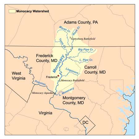
County, Maryland400 cu ft/s (11 m3/s) 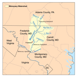 The Monocacy River watershed
The Monocacy River is a free-flowing tributary of the Potomac River, which empties into the Atlantic Ocean via the Chesapeake Bay. The river is 58.5 miles (94.1 km) long,[1] with a drainage area of about 744 square miles (1,930 km2). It is the largest Maryland tributary to the Potomac.
The name "Monocacy" comes from the Shawnee name for the river, Monnockkesey, which translates to "river with many bends." (However, another local tradition asserts that "Monocacy" means "well-fenced garden" in an Indian language.) An unrelated stream, Monocacy Creek, is a tributary of the Lehigh River in Northampton County, Pennsylvania, in the United States.
The Monocacy National Battlefield lies alongside part of the river, marking an 1864 engagement during the American Civil War, the Battle of Monocacy Junction. The Chesapeake and Ohio Canal crosses over the river at the Monocacy Aqueduct, the largest of the 11 aqueducts on the canal.
Contents
Geography
The river rises in Carroll County, Maryland, west of the unincorporated town of Harney, at the Maryland-Pennsylvania border. The river is formed by the confluence of Marsh Creek and Rock Creek, which flow out of Adams County, Pennsylvania. Maryland tributaries include Furnace Branch, Tuscarora Creek, Carroll Creek, Linganore Creek and Ballenger Creek in Frederick County and Double Pipe Creek in Carroll County; other Pennsylvania tributaries include Alloway Creek and Toms Creek in Adams County.
About 60% of the Monocacy watershed is dedicated to agricultural use; about 33% of the watershed is forested. The city of Frederick and its suburbs form the largest urban area within the watershed.
Pollution
The State of Maryland designated the Monocacy as a Maryland Scenic River in 1974.[2] However, it has one of the greatest nonpoint source pollution problems in the state due in large part to runoff from the 3,500 farms, livestock operations and dairies in the watershed. The Maryland Department of the Environment (MDE) has listed the Monocacy with impaired water quality for sediment and fecal coliform bacteria.[3][4] A major tributary basin, the Double Pipe Creek watershed, is also impaired for sediment and bacteria.[5][6]
Some farmers in the Monocacy watershed participate in the national Conservation Security Program operated by the U.S. Department of Agriculture (USDA), designed to help stem pollution due to erosion and pollutant runoff from farming.[7] In the 1990s the watershed was part of a national water quality demonstration project sponsored by USDA, which helped farmers reduce fertilizer usage and reduced discharges of nitrogen and phosphorus to the river.[8]
See also
- List of Maryland rivers
- List of rivers of Pennsylvania
References
- ^ U.S. Geological Survey. National Hydrography Dataset high-resolution flowline data. The National Map, accessed August 15, 2011
- ^ Monocacy Scenic River Advisory Board. "Monocacy Scenic River Study and Management Plan." Published by Maryland Department of Natural Resources, Annapolis, MD. 1990. p.3.
- ^ Maryland Department of the Environment (MDE). Baltimore, MD. "Total Maximum Daily Load of Sediment in the Upper Monocacy River Watershed, Frederick and Carroll Counties, Maryland (Draft)." July 1, 2008.][dead link]
"Total Maximum Daily Load of Sediment in the Lower Monocacy River Watershed, Frederick, Carroll, and Montgomery Counties, Maryland." July 22, 2008.[dead link] - ^ MDE. "Total Maximum Daily Loads of Fecal Bacteria for the Upper Monocacy River Basin in Carroll and Frederick Counties, Maryland. August 15, 2007.
"Total Maximum Daily Loads of Fecal Bacteria for the Lower Monocacy River Basin in Carroll, Frederick, and Montgomery Counties, Maryland." July 20, 2007.[dead link] - ^ MDE. “Total Maximum Daily Load of Sediment in the Double Pipe Creek Watershed, Frederick and Carroll Counties, Maryland.” August 2007.[dead link]
- ^ MDE. “Total Maximum Daily Loads of Fecal Bacteria for the Double Pipe Creek Basin in Carroll and Frederick Counties, Maryland (Draft).” June 2007.[dead link]
- ^ U.S. Natural Resources Conservation Service (NRCS). "Conservation Security Program - Monocacy Watershed." Accessed 2009-03-07.
- ^ USDA. "Demonstration Projects – Selected Impacts" October 31, 2006.
External links
- Monocacy Scenic River Water Trail Map & Guide - Maryland DNR
- Monocacy River factsheet - Alliance for the Chesapeake Bay
- Monocacy Watershed profile – US EPA
- Monocacy & Catoctin Watershed Alliance
- Monocacy Aqueduct – C&O Canal Virtual Tour
- Monocacy Basin Stream Monitoring Project
- Monocacy Battlefield – National Park Service
- Fishing the Monocacy River
- Kayaking/Canoeing the Monocacy
- Monocacy Scenic River Citizen's Advisory Board
Potomac River system
Cities and towns | Bridges | Islands | Tributaries | Variant names
District of Columbia | Maryland | Pennsylvania | Virginia | West Virginia
Streams shown as: Major tributaries • subtributaries • (subsubtributaries) • (subsubsubtributaries)Lakes and reservoirsWaters of Maryland Bays/Estuaries Assawoman • Chesapeake • Chincoteague • Eastern • Fishing • Herring • Isle of Wight • Mallows • Newport • Pocomoke • Sinepuxent • TangierRivers Anacostia • Annemessex (Big) • Annemessex (Little) • Back • Bird • Blackwater • Blackwater (Little) • Bohemia • Bush • Casselman • Chester • Chicamacomico • Choptank • Choptank (Little) • Christina River • Corsica • Elk • Front • Gunpowder • Hawlings • Jones Falls • Magothy • Magothy (Little) • Manokin • Middle • Miles • Monocacy • Monocacy (Little) • Nanticoke • North East • Patapsco • Patuxent • Pocomoke • Port Tobacco • Potomac • Rhode • St. Martin • St. Marys • Sassafras • Savage • Severn • South • Susquehanna • Transquaking • Tred Avon • Warwick • West • Wicomico (Potomac) • Wicomico • Wye • Wye East • YoughioghenyCreeks/Runs/Streams Antietam • Alloway • Ballenger • Bear (Patapsco) • Bear (Sideling Hill) • Bear (Youghiogheny) • Bennett • Big Pipe • Bodkin • Bread and Cheese • Broad (Choptank) • Broad (Potomac) • Broad (Susquehanna) • Broad Run • Budds • Cabin John • Carroll • Catoctin • Catoctin (Little) • Chicamuxen • Conococheague • Conococheague (Little) • Conowingo • Cuckold • Curtis • Deep Run • Deer • Dividing • Double Pipe • Dry Seneca • Dueling • Dundee • Evitts • Fifteenmile • Fishing • Flintstone • Frog Mortar • Furnace • Georges • Great Seneca • Greys • Gwynns Falls • Harris • Henson • Herring Run • Honga • Indian (Anacostia) • Indian (Patuxent) • Israel • Laurel Run • Licking • Linganore • Little Falls Branch • Little Pipe • Little Seneca • Lyons • Main • Marley • Marsh • Marshyhope • Mattawoman • Meekins • Middle • Minnehaha Branch • Moores Run • Muddy Branch • Nanjemoy • Nassawango • Northeast Branch Anacostia River • Northwest Branch Anacostia River • Octoraro • Owens • Oxon • Paint Branch • Parsons • Piney • Piscataway • Pomonkey • Rock (Potomac) • Rock Run • Rockburn Branch • Romney • St. Leonard • Saltpeter • Sams Creek • Sellman • Seneca (Middle) • Seneca (Potomac) • Sideling Hill • Slaughter • Sligo • Stony • Swanson • Toms • Tonoloway • Town (Patuxent) • Town (Potomac) • Town (Tred Avon) • Trappe • Tuckahoe • Turville • Tuscarora (Monocacy) • Tuscarora (Potomac) • Tuscarora (Little) • Watts Branch • Wills • Winters RunLakes Artemesia • Centennial • Deep Creek • Elkhorn • Bernard Frank • Jennings Randolph • Kittamaqundi • Little Seneca • Needwood • Roland • YoughioghenyReservoirs Categories:- Geography of Carroll County, Maryland
- Geography of Frederick County, Maryland
- Rivers of Maryland
- Rivers of Pennsylvania
- Geography of Adams County, Pennsylvania
- Monocacy River
Wikimedia Foundation. 2010.