- McMillan Reservoir
-
McMillan Reservoir 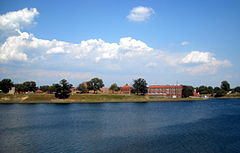
Location Washington, D.C. Coordinates 38°55′30″N 77°01′02″W / 38.9251°N 77.0173°WCoordinates: 38°55′30″N 77°01′02″W / 38.9251°N 77.0173°W Lake type reservoir Primary inflows Washington Aqueduct Basin countries United States Surface area 25 acres (10 ha) The McMillan Reservoir is a reservoir in Washington, D.C. that supplies the majority of the city's municipal water. It was originally called the Howard University Reservoir or the Washington City Reservoir, and was completed in 1902 by the U.S. Army Corps of Engineers.[1] The reservoir was built on the site of Smith Spring, one of the springs previously used for drinking water. Washington's earliest residents relied on natural springs but this came to be inadequate as the city's population grew. In 1850, Congress determined that the Potomac River should be the city's principal source of water.
Contents
Construction history
Washington Aqueduct
A Congressionally funded engineering study was conducted to determine the most available mode of supplying water to the city. Work and study conducted under the leadership of Lieutenant Montgomery C. Meigs culminated into the development of the Washington Aqueduct which began operations on January 3, 1859.[2] (Initially the system provided water to the city from the Little Falls Branch in Maryland, until the aqueduct construction was completed.) Regular water service from the Potomac River source through the aqueduct commenced in 1864.
Washington City Tunnel
In the early years of operation the water was routed through the system's two earlier-built reservoirs, Dalecarlia and Georgetown, which were designed to settle sediment out of the water. In 1873 the Army began construction of a new water supply tunnel, known as the Washington City Tunnel, to provide more storage, sedimentation and distribution capacity for the system. Construction of the tunnel was halted in in the 1880s due to a variety of problems including funding shortages, cost overruns, bribery and fraud associated with the construction process.[2]:73,83 During that period some improvements were made to the Dalecarlia portion of the system, and work on the tunnel finally resumed in 1898. The tunnel was completed in 1901 and the McMillan Reservoir began operation in 1902.
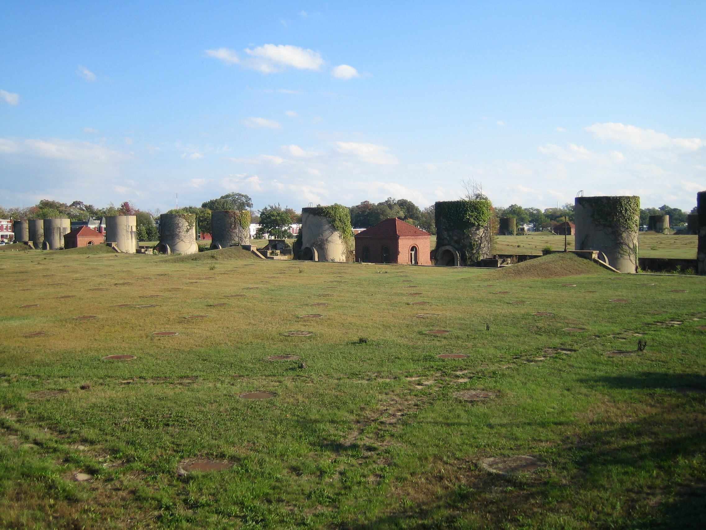
Filtration plant
 The District of Columbia government is considering redevelopment plans for the McMillan sand filtration plant which is no longer used for water treatment.
All the District's water needs were thought to have been quenched by the water aqueduct system, but by 1902 it became apparent that it was no longer adequate. To handle population growth and municipal sanitation needs, officials added the McMillan Reservoir Filtration Plant in 1905. This facility implemented an innovative water purification system relying on sand instead of chemicals to filter 75 million gallons (280 million liters) per day. It helped quell typhoid epidemics and other communicable diseases throughout the city.
In 1907 the reservoir and filtration plant were named in honor of Senator James McMillan of Michigan, who chaired the Senate Committee on the District of Columbia and supported development of the water supply facilities.
Subsequent improvements to the city water system were initiated beginning in the 1920s. The regular use of chlorine as a disinfectant began in 1923 at the McMillan filtration plant. Another treatment plant was completed in 1928, and this was built adjacent to the Dalecarlia Reservoir.[2]:101-105 The growth of the city population led to further expansions at the Dalecarlia site in the 1950s.
McMillan Fountain
Main article: McMillan FountainThe McMillan Fountain is a public artwork by American artist Herbert Adams located on the Reservoir grounds. The fountain, completed in 1912 and dedicated in October 1919, consists of a bronze The Three Graces placed upon a pink granite base. Cast by Roman Bronze Works, the fountain was originally part of a large landscape setting designed by Charles A. Platt. A tribute to James McMillan, the fountain was paid for by citizens of Michigan, who raised $25,000 by way of pennies, nickels and dimes donated by public school children. Congress also funded totaling $15,000 towards the completion.[3][4]
Recent developments
The slow sand filter plant at McMillan was replaced in 1985 with a new rapid sand filter plant.
The old water treatment site was purchased by the District of Columbia from the federal government in 1987 for $9.3 million, and since has deteriorated due to lack of maintenance. The question of what to do with the property is up for debate.[5]
The 25 acre (100,000 m²) McMillan Reservoir, located between Michigan Avenue, North Capitol Street, and First Street in Northwest Washington, D.C., was designated a DC Historic Landmark in 1991.
See also
References
- ^ Scott, Pamela (2007), "Capital Engineers: The U.S. Army Corps of Engineers in the Development of Washington, D.C., 1790-2004." p. 175. Washington, DC: U.S. Army Corps of Engineers. Publication No. EP 870-1-67.
- ^ a b c Ways, Harry C. (1996), "The Washington Aqueduct: 1852-1992," Baltimore, MD: U.S. Army Corps of Engineers, Baltimore District.
- ^ Louise Todd Ambler & Marilyn Gage Hyson (2003). "McMillan Fountain (sculpture)". Untitled Checklist. Smithsonian. http://siris-artinventories.si.edu/ipac20/ipac.jsp?&profile=all&source=~!siartinventories&uri=full=3100001~!359968~!0#focus. Retrieved 14 December 2010.
- ^ Somma, Thomas P. "The McMillan Memorial Fountain: A Short History of a Lost Monument", Washington History, Vol 14, No. 2, pp. 96-107.
- ^ Layton, Lyndsey (April 22, 2006). "What to Do with What Lies Beneath?". Washington Post: p. B01. http://www.washingtonpost.com/wp-dyn/content/article/2006/04/21/AR2006042101819.html.
External links
- D.C. Preservation League
- D.C. Water and Sewer Authority
- Washington Aqueduct - US Army Corps of Engineers
- Pictures of the McMillan slow sand plant, with history
Potomac River system
Cities and towns | Bridges | Islands | Tributaries | Variant names
District of Columbia | Maryland | Pennsylvania | Virginia | West Virginia
Streams shown as: Major tributaries • subtributaries • (subsubtributaries) • (subsubsubtributaries)Lakes and reservoirsCategories:- Chesapeake Bay Watershed
- Reservoirs in the District of Columbia
- Potomac River Watershed

Wikimedia Foundation. 2010.