- Northwest Branch Anacostia River
-
Northwest Branch Anacostia River Country United States State Maryland Tributaries - left Old Orchard, Bryants Nursery, Norwood, Rolling Stone - right Bachelors Forest, Longmeade, Bel Pre Creek, Wheaton Park, Lamberton Dr, Sligo Creek Cities Wheaton, Silver Spring, Hyattsville Source - location Sandy Spring, Maryland Mouth Anacostia River - location Bladensburg, MD - coordinates 38°56′34″N 76°56′39″W / 38.942832°N 76.944036°W Length 21.5 mi (35 km) Basin 53.5 sq mi (139 km2) 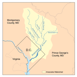 Map of the Anacostia River watershed showing the Northwest Branch
Northwest Branch Anacostia River is a 21.5-mile-long (34.6 km)[1] free-flowing stream in Montgomery County and Prince George's County, Maryland. It is a tributary of the Anacostia River, which flows to the Potomac River and the Chesapeake Bay.
Contents
Course
The headwaters of the Northwest Branch are located near the community of Sandy Spring. The stream flows southward for 21.5 miles (34.6 km) to its confluence with the Northeast Branch near Bladensburg to form the main stem of the Anacostia.[2]
Watershed
The watershed in Montgomery County includes portions of the communities of Norwood, Bel Pre Manor, Colesville, Layhill, Glenmont, Wheaton, Hillandale, White Oak, Silver Spring, Kemp Mill, Four Corners and Takoma Park. The Prince George's County portion of the watershed includes Langley Park, University Park, Chillum, Hyattsville, Avondale and Brentwood. The total watershed area, including a small portion of land in Washington, D.C., is 53.5 square miles (139 km2), with a resident population of about 254,000.[3][4]
The middle section of the Northwest Branch is referred to as the Rachel Carson Environmental Area. It flows through a small gorge underneath the Capital Beltway between Colesville Road and Adelphi Mill. Located at the north end of the Northwest Branch Trail, near the home of noted environmental author Rachel Carson, it is deliberately left rustic and unimproved.[5]
The majority of the Northwest Branch stream valley is a riparian buffer, protected as parkland by the Maryland-National Capital Park and Planning Commission (M-NCPPC).[3] The Rachel Carson Greenway planned by M-NCPPC will extend the Northwest Branch Trail into northern Montgomery County as an unimproved hiking trail, connecting to the Anacostia Tributary Trail System in Prince Georges County.
Geology
Northwest Branch crosses the geological fall line between the piedmont and Atlantic coastal plain regions, which forms a small waterfall on the stream near White Oak.
Tributaries
The total stream channel length of Northwest Branch and all tributaries is 75 miles (121 km).
- Bachelors Forest Tributary
- Bel Pre Creek
- Bryants Nursery Tributary
- Lamberton Drive Tributary
- Lockridge Drive Tributary
- Longmeade Tributary
- Old Orchard Tributary
- Rolling Stone Tributary
- Sandy Spring Tributary
- Sligo Creek
- Wheaton Park Tributary
See also
- List of Maryland rivers
- Anacostia Tributary Trails
References
- ^ U.S. Geological Survey. National Hydrography Dataset high-resolution flowline data. The National Map, accessed August 15, 2011
- ^ Neighbors of the Northwest Branch. "Mission Statement." Accessed 2009-08-31.
- ^ a b Anacostia Watershed Restoration Partnership (AWRP). Washington, DC. "Northwest Branch: Profile." Accessed 2010-06-21.
- ^ AWRP. "Sligo Creek: Profile." Accessed 2010-06-21.
- ^ Montgomery Parks/MNCPPC. "Rachel Carson Greenway & Northwest Branch Stream Valley Park Trails." Accessed 2009-11-14.
- Montgomery County Department of Environmental Protection (MCDEP)(1997). "Northwest Branch Watershed Study." Rockville, MD. March 17, 1997.
- MCDEP. "Countywide Stream Protection Strategy: Northwest Branch Watershed." Accessed 2009-08-30.
- Anacostia Watershed Restoration Partnership (2008). "Anacostia River Watershed Restoration Plan: Interim Report Framework, September 2007–November 2008." Report to Congress.
External links
- Neighbors of the Northwest Branch
- Anacostia Watershed Society - Detailed maps and photos of stream conditions
- Anacostia Watershed Restoration Partnership
- Northwest Branch Trail - Montgomery County Dept. of Parks
- Wheaton Regional Park - Montgomery County Dept. of Parks
- Anacostia Tributary Trail System - Prince George's County Dept. of Parks & Recreation
Potomac River system
Cities and towns | Bridges | Islands | Tributaries | Variant names
District of Columbia | Maryland | Pennsylvania | Virginia | West Virginia
Streams shown as: Major tributaries • subtributaries • (subsubtributaries) • (subsubsubtributaries)Lakes and reservoirsWaters of Maryland Bays/Estuaries Assawoman • Chesapeake • Chincoteague • Eastern • Fishing • Herring • Isle of Wight • Mallows • Newport • Pocomoke • Sinepuxent • TangierRivers Anacostia • Annemessex (Big) • Annemessex (Little) • Back • Bird • Blackwater • Blackwater (Little) • Bohemia • Bush • Casselman • Chester • Chicamacomico • Choptank • Choptank (Little) • Christina River • Corsica • Elk • Front • Gunpowder • Hawlings • Jones Falls • Magothy • Magothy (Little) • Manokin • Middle • Miles • Monocacy • Monocacy (Little) • Nanticoke • North East • Patapsco • Patuxent • Pocomoke • Port Tobacco • Potomac • Rhode • St. Martin • St. Marys • Sassafras • Savage • Severn • South • Susquehanna • Transquaking • Tred Avon • Warwick • West • Wicomico (Potomac) • Wicomico • Wye • Wye East • YoughioghenyCreeks/Runs/Streams Antietam • Alloway • Ballenger • Bear (Patapsco) • Bear (Sideling Hill) • Bear (Youghiogheny) • Bennett • Big Pipe • Bodkin • Bread and Cheese • Broad (Choptank) • Broad (Potomac) • Broad (Susquehanna) • Broad Run • Budds • Cabin John • Carroll • Catoctin • Catoctin (Little) • Chicamuxen • Conococheague • Conococheague (Little) • Conowingo • Cuckold • Curtis • Deep Run • Deer • Dividing • Double Pipe • Dry Seneca • Dueling • Dundee • Evitts • Fifteenmile • Fishing • Flintstone • Frog Mortar • Furnace • Georges • Great Seneca • Greys • Gwynns Falls • Harris • Henson • Herring Run • Honga • Indian (Anacostia) • Indian (Patuxent) • Israel • Laurel Run • Licking • Linganore • Little Falls Branch • Little Pipe • Little Seneca • Lyons • Main • Marley • Marsh • Marshyhope • Mattawoman • Meekins • Middle • Minnehaha Branch • Moores Run • Muddy Branch • Nanjemoy • Nassawango • Northeast Branch Anacostia River • Northwest Branch Anacostia River • Octoraro • Owens • Oxon • Paint Branch • Parsons • Piney • Piscataway • Pomonkey • Rock (Potomac) • Rock Run • Rockburn Branch • Romney • St. Leonard • Saltpeter • Sams Creek • Sellman • Seneca (Middle) • Seneca (Potomac) • Sideling Hill • Slaughter • Sligo • Stony • Swanson • Toms • Tonoloway • Town (Patuxent) • Town (Potomac) • Town (Tred Avon) • Trappe • Tuckahoe • Turville • Tuscarora (Monocacy) • Tuscarora (Potomac) • Tuscarora (Little) • Watts Branch • Wills • Winters RunLakes Artemesia • Centennial • Deep Creek • Elkhorn • Bernard Frank • Jennings Randolph • Kittamaqundi • Little Seneca • Needwood • Roland • YoughioghenyReservoirs Categories:- Anacostia River
- Geography of Montgomery County, Maryland
- Geography of Prince George's County, Maryland
- Rivers of Maryland

Wikimedia Foundation. 2010.