Adelphi Mill

Adelphi Mill

Infobox nrhp
name = Adelphi Mill
nrhp_type =


imagesize=260px
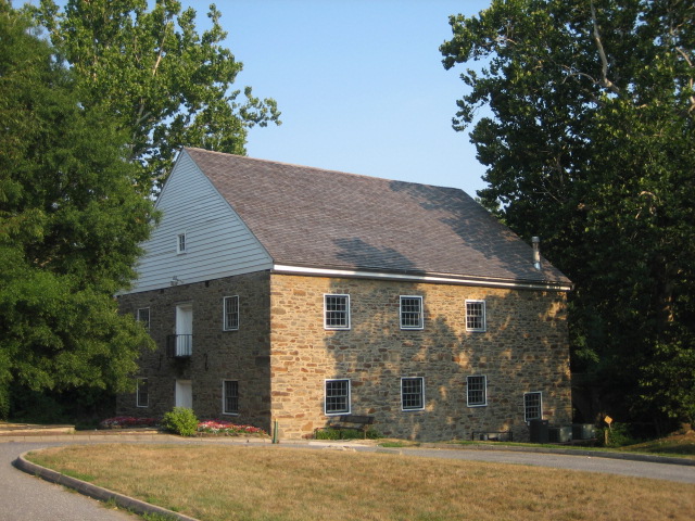
caption = Adelphi Mill in July of 2007
lat_degrees = 38
lat_minutes = 59
lat_seconds = 34
lat_direction = N
long_degrees = 76
long_minutes = 58
long_seconds = 20
long_direction = W
location = 8402 Riggs Road, Adelphi, Maryland 20783, USA
nearest_city = Takoma Park, Maryland
area = Architecture, Social History
built = 1796
architect =
title =
work =
publisher = National Park Service, National Register of Historic Places
date =
url =
format =
doi =
accessdate =
last =
first =
title =
publisher =
date =
location =
pages =
id =
LCCN =
architecture =
designated =
added =
established =
visitation_num =
visitation_year =
refnum =
mpsub =
governing_body =

The Adelphi Mill, built in 1796, is the only surviving historic mill in Prince George's County. It is the oldest and largest mill in the Washington D.C. area. It is located at 8402 Riggs Road, Adelphi, MD 20783.

Gallery

External links

* [http://www.pgparks.com/places/eleganthistoric/adelphi_intro.html Adelphi Mill] , Department of Parks and Recreation, Prince George's County

References

*This article contains information from the Maryland National Capital Park and Planning Commission's page on the Adelphi Mill.


Wikimedia Foundation. 2010.

Игры ⚽ Поможем написать курсовую

Look at other dictionaries:

  • Adelphi, Maryland — Infobox Settlement official name = Adelphi, Maryland settlement type = CDP nickname = motto = imagesize = image caption = image imagesize = image caption = image mapsize = 250x200px map caption = Location of Adelphi, Maryland mapsize1 = map… …   Wikipedia

  • Bollington — infobox UK place country = England official name= Bollington latitude= 53.298 longitude= 2.093 population = 7,095 civil parish= Bollington shire district= Macclesfield region= North West England shire county = Cheshire constituency westminster=… …   Wikipedia

  • Northwest Branch Anacostia River — Coordinates: 38°56′34″N 76°56′39″W / 38.942832°N 76.944036°W / 38.942832; 76.944036 …   Wikipedia

  • Civil parishes in Cheshire — A map of Cheshire, showing the Boroughs : (1) Cheshire West and Chester; (2) Cheshire East; (3) Warrington; and (4) Halton. A civil parish is a subnational entity, forming the lowest unit of local government in England. There are 332 civil… …   Wikipedia

  • Maryland Route 650 — New Hampshire Avenue …   Wikipedia

  • Mary Harris Jones — Mother Jones Born August 1, 1837(1837 08 01) Cork, County Cork, Ireland Died November 30, 1930 …   Wikipedia

  • Death Chants, Breakdowns & Military Waltzes — Cover of the second edition Studio album by John Fahey Release …   Wikipedia

  • Colmar Manor, Maryland —   Town   Seal …   Wikipedia

  • Maryland Route 193 — University Boulevard, Greenbelt Road …   Wikipedia

  • College Park, Maryland — College Park, MD   City   Seal …   Wikipedia

Share the article and excerpts

Direct link
Do a right-click on the link above
and select “Copy Link”