- Marshyhope Creek
-
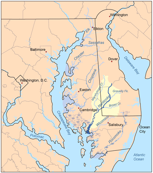
 Map of the rivers of the Eastern Shore of Maryland with the Nanticoke and its watershed highlighted and showing Marshyhope Creek.
Marshyhope Creek is a 37.0-mile-long (59.5 km)[1] tributary of the Nanticoke River on the Delmarva Peninsula. It rises in Kent County, Delaware, and runs through Caroline County, Maryland, and Dorchester County, Maryland.
Marshyhope Creek begins in southwestern Kent County, Delaware, near the city of Harrington, and ends at the Nanticoke River, near Sharptown, Maryland. The entire watershed is in the coastal plain and reaches sea level at Brookview, Maryland. Federalsburg is the head of navigation.
There are several small creeks on the western shore, including Faulkner Branch, Sullivan Branch, Capital Branch, Green Branch, and Horsepen Arm. On the eastern shore the small creeks include Tanyard Branch, Houston Branch, Jones Mill Branch, Double Fork Branch, Quarter Branch, Tomahawk Branch, and Prospect Point Branch.
See also
References
- ^ U.S. Geological Survey. National Hydrography Dataset high-resolution flowline data. The National Map, accessed April 1, 2011
- United States Geological Survey. 7.5 minute series topographic quadrangles
Coordinates: 38°45′14″N 75°44′33″W / 38.753845°N 75.742624°W
Waters of Maryland Bays/Estuaries Assawoman • Chesapeake • Chincoteague • Eastern • Fishing • Herring • Isle of Wight • Mallows • Newport • Pocomoke • Sinepuxent • TangierRivers Anacostia • Annemessex (Big) • Annemessex (Little) • Back • Bird • Blackwater • Blackwater (Little) • Bohemia • Bush • Casselman • Chester • Chicamacomico • Choptank • Choptank (Little) • Christina River • Corsica • Elk • Front • Gunpowder • Hawlings • Jones Falls • Magothy • Magothy (Little) • Manokin • Middle • Miles • Monocacy • Monocacy (Little) • Nanticoke • North East • Patapsco • Patuxent • Pocomoke • Port Tobacco • Potomac • Rhode • St. Martin • St. Marys • Sassafras • Savage • Severn • South • Susquehanna • Transquaking • Tred Avon • Warwick • West • Wicomico (Potomac) • Wicomico • Wye • Wye East • YoughioghenyCreeks/Runs/Streams Antietam • Alloway • Ballenger • Bear (Patapsco) • Bear (Sideling Hill) • Bear (Youghiogheny) • Bennett • Big Pipe • Bodkin • Bread and Cheese • Broad (Choptank) • Broad (Potomac) • Broad (Susquehanna) • Broad Run • Budds • Cabin John • Carroll • Catoctin • Catoctin (Little) • Chicamuxen • Conococheague • Conococheague (Little) • Conowingo • Cuckold • Curtis • Deep Run • Deer • Dividing • Double Pipe • Dry Seneca • Dueling • Dundee • Evitts • Fifteenmile • Fishing • Flintstone • Frog Mortar • Furnace • Georges • Great Seneca • Greys • Gwynns Falls • Harris • Henson • Herring Run • Honga • Indian (Anacostia) • Indian (Patuxent) • Israel • Laurel Run • Licking • Linganore • Little Falls Branch • Little Pipe • Little Seneca • Lyons • Main • Marley • Marsh • Marshyhope • Mattawoman • Meekins • Middle • Minnehaha Branch • Moores Run • Muddy Branch • Nanjemoy • Nassawango • Northeast Branch Anacostia River • Northwest Branch Anacostia River • Octoraro • Owens • Oxon • Paint Branch • Parsons • Piney • Piscataway • Pomonkey • Rock (Potomac) • Rock Run • Rockburn Branch • Romney • St. Leonard • Saltpeter • Sams Creek • Sellman • Seneca (Middle) • Seneca (Potomac) • Sideling Hill • Slaughter • Sligo • Stony • Swanson • Toms • Tonoloway • Town (Patuxent) • Town (Potomac) • Town (Tred Avon) • Trappe • Tuckahoe • Turville • Tuscarora (Monocacy) • Tuscarora (Potomac) • Tuscarora (Little) • Watts Branch • Wills • Winters RunLakes Artemesia • Centennial • Deep Creek • Elkhorn • Bernard Frank • Jennings Randolph • Kittamaqundi • Little Seneca • Needwood • Roland • YoughioghenyReservoirs Categories:- Chesapeake Bay Watershed
- Rivers of Delaware
- Rivers of Maryland
- Landforms of Kent County, Delaware
- Delaware geography stubs
Wikimedia Foundation. 2010.