- Maryland Route 121
-
Maryland Route 121
Clarksburg Road 
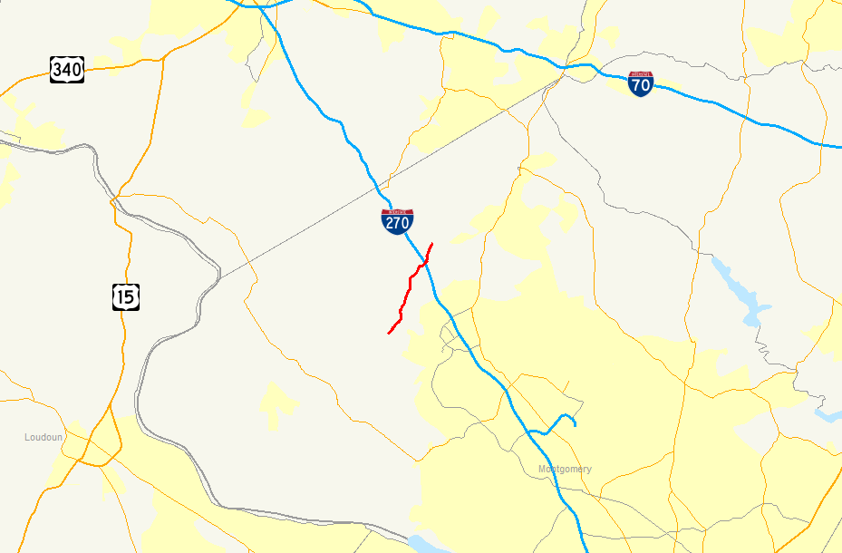
Route information Maintained by MDSHA Length: 4.42 mi[1] (7.11 km) Major junctions South end:  MD 117 in Boyds
 I-270 in Clarksburg
Stringtown Road in Clarksburg
Dead end in ClarksburgNorth end:  MD 355 in Clarksburg
Highway system Maryland highway system
Interstate • US • State • Minor • Former • Turnpikes←  MD 119
MD 122  →
→Maryland Route 121, also known as Clarksburg Road, is a Maryland state highway that goes from Boyds to Clarksburg in Montgomery County, through Black Hill Regional Park.
Contents
Route description
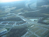
Maryland Route 121 begins at a wide three-way intersection with MD 117 near Boyds. The south and west legs of the intersection consist of MD 117 (Barnesville Road); the north leg is MD 121, following Clarksburg Road, which curves to the northeast on a two-lane, shouldered alignment. It very quickly encounters a bridge over Little Seneca Lake. The shoulders quickly end on the opposite shore and the road curves slightly more sharply as it passes through Burdette's cluster of homes. The route then enters the open countryside, weaving through farms and small patches of woodland before it passes through its interchange with Interstate 270. The MD 121 designation ends at the very last ramp of I-270, as does the road's name of Clarksburg Road. The roadway continues, however, as Stringtown Road, continuing for quite a distance north and ending at Kings Valley Road. A separated section of MD 121 officially designated MD 121A but signed as MD 121 begins at a dead end near of I-270 and heads northeast along Clarksburg Road. It intersects Gateway Center Drive, which connects to Stringtown Road, before coming to an end at MD 355.[1][2]
Junction list
The entire route is in Montgomery County.
Location Mile
[1]Roads intersected Notes Boyds 0.00  MD 117 (Clarkesburg Road) to MD 28
Southern terminus of MD 121 Clarksburg 3.83 I-270 (Eisenhower Memorial Highway) – Frederick, WashingtonI-270 exit 18 3.96 Stringtown Road Northern terminus of MD 121 0.00 Dead end Southern terminus of MD 121A 0.46 MD 355 (Frederick Road) – Hyattstown, ComusNorthern terminus of MD 121A References
- ^ a b c Maryland State Highway Administration (2008). "Highway Location Reference: Montgomery County" (PDF). http://apps.roads.maryland.gov/KeepingCurrent/performTrafficStudies/dataAndStats/hwyLocationRef/2008_hlr_all/co15.pdf. Retrieved 2010-04-21.
- ^ Google, Inc. Google Maps – overview of Maryland Route 121 (Map). Cartography by Google, Inc. http://maps.google.com/maps?f=d&source=s_d&saddr=maryland+117+and+maryland+121&daddr=maryland+121+and+maryland+355&geocode=&hl=en&mra=ls&sll=39.174588,-77.261181&sspn=0.014472,0.042272&ie=UTF8&ll=39.212571,-77.296886&spn=0.057325,0.169086&t=h&z=13. Retrieved 2010-04-27.
External links
Roads in Montgomery County, Maryland Maryland State Highways 
U.S. Routes Interstate Highways Roads by name Cabin John Parkway · Clara Barton Parkway · Cherry Hill Road · Connecticut Avenue · Georgia Avenue · Montrose Road · New Hampshire Avenue · Randolph Road · Sligo Creek Parkway · Wisconsin Avenue · 16th StreetCategories:- State highways in Maryland
- Roads in Montgomery County, Maryland


Wikimedia Foundation. 2010.