- Maryland Route 187
-
Maryland Route 187 Old Georgetown Road 
Route information Maintained by MDSHA Length: 5.32 mi[1] (8.56 km) Major junctions South end: 
 MD 355 / MD 410 at Bethesda
North end:  MD 355 near Rockville
Highway system Maryland highway system
Interstate • US • State • Minor • Former • Turnpikes←  MD 186
MD 188  →
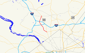
→Maryland Route 187 (MD 187) is a state highway in the U.S. state of Maryland. Known as Old Georgetown Road, the state highway runs 5.32 miles (8.56 km) from MD 355 and MD 410 in Bethesda north to MD 355 in North Bethesda. MD 187 runs parallel to MD 355 through suburban areas of southern Montgomery County.
Contents
Route description
MD 187 begins at an intersection with MD 355 (Wisconsin Avenue) and westbound MD 410 (East–West Highway) next to the Bethesda station of the Washington Metro in downtown Bethesda. The state highway heads northwest as a two-lane one-way street to Woodmont Avenue. Southbound MD 187 traffic is required to turn north or south onto Woodmont Avenue. Woodmont Avenue, which becomes a southbound one-way street at the intersection, leads to Montgomery Lane, which provides access to MD 355 and eastbound MD 410 (Montgomery Avenue). MD 187 heads northwest from Woodmont Avenue as a five-lane highway with center turn lane that passes through a five-way intersection with MD 188 (Wilson Lane), Arlington Road, and St. Elmo Avenue and leaves downtown Bethesda. The state highway veers north and becomes a six-lane divided highway at Suburban Hospital, which sits opposite the southern end of the NIH campus. MD 187 intersects several entrances to the federal campus and passes to the east of the tiny village of Oakmont.[1][2]
MD 187 enters North Bethesda at its diamond interchange with Interstate 495 (Capital Beltway) (I-495). The state highway intersects Democracy Boulevard, a county highway that heads west past Walter Johnson High School and the Montgomery Mall, and meets I-270 (Eisenhower Memorial Highway) at a diamond interchange whose ramps also connect with Rockledge Boulevard. MD 187 heads northeast to its intersection with Executive Boulevard, where the state highway curves to the east and reaches its northern terminus at MD 355 (Rockville Pike) just north of the White Flint Metro station.[1][2]
Junction list
The entire route is in Montgomery County.
Location Mile
[1]Destinations Notes Bethesda 0.00 
 MD 355 (Wisconsin Avenue) / MD 410 (East–West Highway)
Southern terminus; MD 187 begins one-way northbound 0.17 Woodmont Avenue to 
 MD 355 (Wisconsin Avenue) / MD 410 east (Montgomery Avenue) – Rockville, Washington, Silver Spring
Southbound direction of MD 187 ends; southbound traffic must turn onto Woodmont Avenue 0.31  MD 188 west (Wilson Lane) / Arlington Road, St. Elmo Avenue – Glen Echo
2.64  I-495 (Capital Beltway) – Baltimore, Silver Spring, Northern Virginia, Fairfax
I-495 Exit 36 North Bethesda 3.76 
 I-270 (Eisenhower Memorial Highway) to I-495 east – Frederick, Silver Spring
I-270 Exit 1 5.32  MD 355 (Rockville Pike) / Old Georgetown Road east – Rockville, Bethesda
Northern terminus 1.000 mi = 1.609 km; 1.000 km = 0.621 mi Auxiliary route
MD 187B is the designation for the 0.08-mile (0.13 km) section of Rockledge Boulevard within MD 187's interchange with I-270 in North Bethesda.[1][3]
References
- ^ a b c d e "Highway Location Reference: Montgomery County" (PDF). Maryland State Highway Administration. 2009. http://www.marylandroads.com/Location/2009_MONTGOMERY.pdf. Retrieved 2011-05-15.
- ^ a b Google, Inc. Google Maps – Maryland Route 187 (Map). Cartography by Google, Inc. http://maps.google.com/maps?f=d&source=s_d&saddr=bethesda,+md&daddr=Old+Georgetown+Rd&hl=en&geocode=FczbUgIdy6Bn-yktAiRqt8u3iTENzStq93myJg%3BFYbYUwIdzlFn-w&mra=ls&sll=39.017095,-77.110485&sspn=0.120303,0.308647&ie=UTF8&t=h&z=12. Retrieved 2011-05-15.
- ^ Google, Inc. Google Maps – Maryland Route 187B (Map). Cartography by Google, Inc. http://maps.google.com/maps?f=d&source=s_d&saddr=Rockledge+Dr&daddr=Rockledge+Dr&hl=en&geocode=FSSQUwIdGhBn-w%3BFYSUUwIdABFn-w&mra=ls&sll=39.032003,-77.13118&sspn=0.003792,0.009645&ie=UTF8&ll=39.031286,-77.132456&spn=0.007517,0.01929&t=h&z=16. Retrieved 2011-05-15.
External links
Roads in Montgomery County, Maryland Maryland State Highways 
U.S. Routes Interstate Highways Roads by name Cabin John Parkway · Clara Barton Parkway · Cherry Hill Road · Connecticut Avenue · Georgia Avenue · Montrose Road · New Hampshire Avenue · Randolph Road · Sligo Creek Parkway · Wisconsin Avenue · 16th StreetCategories:- State highways in Maryland
- Roads in Montgomery County, Maryland
Wikimedia Foundation. 2010.


