- Maryland Route 117
-
Maryland Route 117
Bucklodge Road, Clopper Road, West Diamond Avenue 
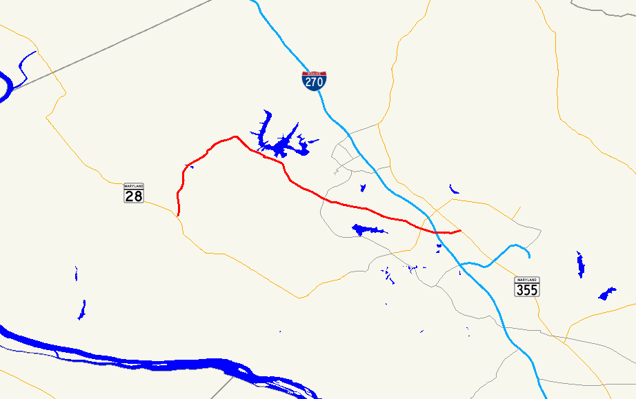
Route information Maintained by MDSHA Length: 12.67 mi[1] (20.39 km) Major junctions West end:  MD 28 near Dawsonville
 I-270
I-270East end:  MD 355 in Gaithersburg
Highway system Maryland highway system
Interstate • US • State • Minor • Former • Turnpikes←  MD 115
MD 118  →
→Maryland Route 117 is the one of three highways connecting the major Washington, D.C. suburbs of Gaithersburg and Germantown (the other two being Interstate 270 and Maryland Route 355). Its 12.67-mile (20.39 km) span consists of three roads: West Diamond Avenue at the easternmost section, Clopper Road for the majority of Route 117's length as it moves into Gaithersburg and into Boyds, then Bucklodge Road from Boyds to its termination at Maryland Route 28.
Contents
Route description
Maryland Route 117 begins at Route 28 in Boyds near Darnestown, where it heads north on two-lane Bucklodge Road through open fields and woodland. It turns to the northeast, and once it passes the Brunswick Line of the MARC Train, it intersects Barnesville Road, taking its name as it turns southeast. At Boyds, the route intersects MD 121, turning south for a very short stretch to pass under the Brunswick Line once again. It then turns east, paralleling the railroad for a short while on Clopper Road and heads into Germantown where MD 117 is a two-lane and four-lane divided road at various points.[1][2]
MD 117 continues east and enters Clopper, where it intersects Maryland Route 124. The road's name then becomes West Diamond Avenue, a four-lane divided road on either side of its interchange with Interstate 270, where it squeezes to three lanes to fit underneath the freeway. It then continues for another short stretch to an interchange with Maryland Route 355 (consisting of a spur of MD 117 called 117A), where the road continues as Old Towne Avenue. At Fulks Corner Avenue, the MD 117 designation ends and municipal maintenance begins; Fulks Corner provides access to MD 355. Old Towne Avenue, however, continues for a very short stretch more to Summit Avenue.[1][2]
Points of interest along MD 117 include Old Town Gaithersburg at its eastern end, the National Institute of Standards and Technology near Route 124, Seneca Creek State Park near the Germantown/Gaithersburg border, Little Seneca Regional Park near the Germantown/Boyds border, and the ruins of Clopper's Mill, located near the intersection of Waring Station Rd. and Clopper Rd., at this location: googlemap
The Germantown/Boyds section west of Maryland Route 119 to Bucklodge Road was largely farmland until the early 1990s, when the rapid development of Germantown began to replace much of the farmland with new home communities. Much of the western five miles (8 km) remains undeveloped.
This road is also the inspiration for the song "Take Me Home, Country Roads" by John Denver.[3]
Junction list
The entire route is in Montgomery County.
Location Mile
[1]Roads intersected Notes Dawsonville 0.00 MD 28 (Darnestown Road)Western terminus Boyds 5.23  MD 121 north (Clarksburg Road)
Germantown 7.57 MD 118 (Germantown Road) – Germantown, Darnestown8.06  MD 119 (Great Seneca Highway)
Gaithersburg 11.26  MD 124 (Quince Orchard Road) – Darnestown
11.45 Bureau Drive Entrance to NIST 11.75 I-270 south (Eisenhower Memorial Highway) – WashingtonI-270 exit 10 12.52 MD 355 (Frederick Road)12.71 Fulks Corner Avenue Eastern terminus References
- ^ a b c d Maryland State Highway Administration (2008). "Highway Location Reference: Montgomery County" (PDF). http://apps.roads.maryland.gov/KeepingCurrent/performTrafficStudies/dataAndStats/hwyLocationRef/2008_hlr_all/co15.pdf. Retrieved 2010-04-21.
- ^ a b Google, Inc. Google Maps – overview of Maryland Route 117 (Map). Cartography by Google, Inc. http://maps.google.com/maps?f=d&source=s_d&saddr=maryland+28+and+maryland+117&daddr=Clopper+Rd+to:W+Diamond+Ave+to:maryland+355+and+maryland+117&geocode=FX9iVQIdEI5j-ymTqnCCky-2iTHfZvZ6hbE7fg%3BFfB2VQIdGhdl-w%3BFZI-VQIdhAFm-w%3BFbU9VQIdbAxm-ylxTVKaLS22iTGquKCP351pYA&hl=en&mra=ls&via=1,2&sll=39.140546,-77.193696&sspn=0.007606,0.021136&ie=UTF8&t=h&z=13. Retrieved 2010-04-26.
- ^ http://www.billdanoff.com/BillJohnDenver.htm
External links
Roads in Montgomery County, Maryland Maryland State Highways 
U.S. Routes Interstate Highways Roads by name Cabin John Parkway · Clara Barton Parkway · Cherry Hill Road · Connecticut Avenue · Georgia Avenue · Montrose Road · New Hampshire Avenue · Randolph Road · Sligo Creek Parkway · Wisconsin Avenue · 16th StreetCategories:- State highways in Maryland
- Roads in Montgomery County, Maryland


Wikimedia Foundation. 2010.