- Maryland Route 198
-
Maryland Route 198
Spencerville Road, Old Columbia Pike, Sandy Spring Road, Gorman Avenue/Talbott Avenue, Fort Meade Road, Laurel-Fort Meade Road 
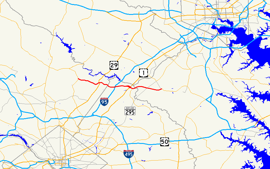
Route information Maintained by MDSHA Length: 14.14 mi[1] (22.76 km) Existed: 1933 – present Major junctions West end:  MD 650 at Spencerville
 US 29 at Burtonsville
 I-95 in Laurel
 US 1 in Laurel
 MD 197 in Laurel
 MD 295 / B-W Parkway east of Laurel
East end:  MD 32 at Fort Meade
Highway system Maryland highway system
Interstate • US • State • Minor • Former • Turnpikes← MD 197MD 200  →
→Maryland Route 198 is an east–west state highway in the central part of the U.S. state of Maryland that connects Fort Meade at Maryland Route 32 to Maryland Route 28 and Maryland Route 650 (New Hampshire Avenue) near Spencerville.
Contents
Route description
Spencerville Road
MD 198 begins at a four-way intersection between MD 650 New Hampshire Avenue and Norbeck Road (an at-grade extension of MD 28 from its eastern terminus at MD 182), several miles to the south of Ashton. Originally, Norbeck Road did not exist at this intersection, and MD 198 ended at a small three-way intersection with MD 650 several hundred yards to the north.
East of here, MD 198 is a busy 40 mph (64 km/h) suburban/rural arterial known as Spencerville Road, carrying traffic through central Montgomery County. Three miles to the east, in downtown Burtonsville, it encounters Old Columbia Pike, the original alignment of US 29, and also formerly signed as MD 196. At this intersection, MD 198 assumes the name of Old Columbia Pike. A short distance further east, the route encounters a second alignment of US 29, known as Columbia Pike, that was built in the late 1960s to carry the U.S. route around the Burtonsville Crossing Shopping Center. After the completion of roadworks on December 7, 2005[2], this alignment of US 29 is out of use as a through mainline route and now serves merely as a local arterial for the community; the segment north of MD 198 ends at Dustin Road, while the segment south was removed. Slightly further to the east, MD 198 encounters the current alignment of US 29 through Burtonsville. This alignment is much straighter than the previous alignment and links with MD 198 via a grade-separated 3/4 diamond interchange.
Sandy Spring Road
Beyond the route's interchange with US 29, MD 198 widens into a four-lane non-limited access arterial and carries moderate to heavy amounts of traffic on an east–west alignment. Here, it is known as Sandy Spring Road, and passes to the north of a major industrial complex and electrical substation before meeting I-95. The two routes interchange via a large, high-speed partially unrolled cloverleaf, with the connection between MD 198 west and I-95 south being served via a semidirectional ramp. In the northeast quadrant of the interchange, Old Sandy Spring Road (a former alignment of MD 198) begins at a dead end and parallels the current routing eastward.
Beyond I-95, MD 198 maintains its four-lane non-limited access cross-section as it passes a major branch office of Tower Federal Credit Union as it enters Laurel.
Gorman Avenue/Talbott Avenue
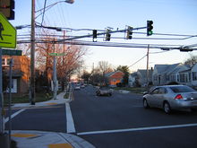 MD 198 eastbound at Fourth Street in Laurel
At 9th St. in downtown Laurel, MD 198 splits into a one-way couplet; the eastbound component is known as Gorman Avenue, and the westbound component is known as Talbott Avenue. Heading east, the couplet crosses the southern terminus of MD 216 (7th St.) and US 1, itself a couplet.
Fort Meade Road
At US 1, the couplet collapses into a normal four-lane non-limited access carriageway as it crosses the B&O Capital Subdivision (also known as the MARC Camden Line) and Lafayette Road. Beyond the crossing, MD 198 is known as Fort Meade Road, and meets the northern terminus of MD 197 several hundred yards east of the B&O. Past MD 197, MD 198 resumes its four-lane non-limited access cross section and again serves as a major arterial, carrying heavy suburban and commuter traffic between Laurel and points east. Near the route's crossing of the Patuxent River, the route connects with Laurel Race Track Road, which serves the Laurel Park Racecourse. Continuing east, the route crosses several suburban and rural roads before meeting the Baltimore-Washington Parkway at a modified cloverleaf interchange.
Laurel-Fort Meade Road
Beyond the B-W Parkway, MD 198 narrows to a fast two-lane highway known locally as Laurel-Fort Meade Road and continues due east, passing an old alignment of MD 216 and crossing the Little Patuxent River near a water treatment plant before veering away from its original alignment to run parallel to MD 32 for a short distance. Eventually, MD 198 reaches a dumbbell interchange with MD 32. Beyond this interchange, MD 198 becomes unsigned and winds its way to the entrance to Fort Meade, where it terminates; the roadway continues into the fort as Mapes Rd., eventually reaching MD 175.
Junction list
County Location Mile Destinations Notes Montgomery Spencerville 0.0 MD 650 (New Hampshire Avenue) – Ashton, White OakWestern terminus
Continues west as Norbeck Road to MD 280.73 Good Hope Road south – Spencerville Park 1.51 Peach Orchard Road south 1.97 Oursler Road north – Burtonsville Park 2.31 Kruhm Road – Union Cemetery (Burtonsville) Burtonsville 3.11 Old Columbia Pike south – White Oak (to US 29) Former alignment of both MD 196 and US 29 3.45 US 29 north (Columbia Pike) – Burtonsville Crossing Shopping CenterFormer US 29 between 1966 and 2005; route is unsigned US 29A 3.61 US 29 (Columbia Pike) – Columbia, White OakInterchange 4.21 Cedar Tree Drive south 4.75 Riding Stable Road north – to Brooklyn Bridge Road Prince George's 5.13 Old Gunpowder Road /Bond Mill Road 5.56 Sweitzer Lane road serves a major industrial complex 6.09 I-95 – Baltimore, WashingtonInterchange Laurel 7.09 Van Dusen Road – Laurel Regional Hospital, Tower Federal Credit Union (to Old Sandy Spring Rd.) 7.7 9th Street road leads to former MD 216 crossing of Patuxent River  splits into two one-way streets: Talbot Avenue westbound and Gorman Avenue eastbound
7.94  MD 216 north (7th Street)
MD 216 is maintained by the city of Laurel 8.35 US 1 south (Laurel Mall), MuirkirkSouthbound one-way couplet of US 1 8.42 US 1 north (2nd Street) – SavageNorthbound one-way couplet of US 1 merges into one two-way roadway and crosses the B&O Capital Subdivision8.82 MD 197 south (Laurel Bowie Road / Irving Street) – BowieMD 197 runs south of MD 198 Anne Arundel 9.35 Laurel Race Track Road – Laurel Race Track Maryland City 9.76 To MD 32 (Brock Bridge Road)10.32 Old Annapolis Road / Whiskey Bottom Road – Bacontown Recreation Area, Maryland City Park 10.65 Red Clay Road / Russett Green W. 10.89 Russett Green E. 11.13  MD 295 / Baltimore-Washington Parkway – Baltimore, Washington
Interchange 12.11 Old Portland Road Former alignment of MD 216
Alignment is unsigned MD 216B and 216I respectively12.25 Welchs Court 12.83 Bald Eagle Drive south – Patuxent Wildlife Research Refuge 13.15 Old GV 198 former alignment of MD 198 13.56 Airfield Road – Tipton Airfield 13.79 MD 32 (Patuxent Freeway / Mapes Road) – Columbia, OdentonInterchange Fort Meade 14.14 Fort Meade Entrance Eastern terminus
Road continues into fort as Mapes RoadHistory
After MD 216 was severed by the Baltimore-Washington Parkway in the 1950s, MD 198 was extended east of Laurel to replace it. Before the construction of the Patuxent Freeway (Maryland Route 32) was begun between the MD 32/I-95 interchange and MD 32/B-W Parkway interchange, MD 198 was a far better route for commuters traveling from the west and south who wished to access Fort Meade, as MD 32's routing at the time (Guilford Road) was a small, two-lane country road with very low traffic-carrying capacity. The design of the I-95/MD 198 interchange, with the semidirectional connection from MD 198 west to I-95 south, further alludes to MD 198's former importance as the primary access point from points west to Fort Meade.
In 1989, a new overpass to carry Route 198 over the Baltimore-Washington Parkway just east of Laurel collapsed during rush hour, injuring 14 motorists and construction workers. The incident was blamed on faulty scaffolding used to support the uncompleted span.[3]
References
- ^ Maryland State Highway Administration, Highway Location Reference, 2005
- ^ WBCM - U.S. 29 at MD 198 Relocation and Interchange Improvements
- ^ Sheila Rimal Duwadi (1991-09-01). "Bridge temporary works research program - bridge collapse". Public Roads. http://www.findarticles.com/p/articles/mi_m3724/is_n2_v55/ai_11289626. Retrieved 2006-10-27.
Roads in Montgomery County, Maryland Maryland State Highways 
U.S. Routes Interstate Highways Roads by name Cabin John Parkway · Clara Barton Parkway · Cherry Hill Road · Connecticut Avenue · Georgia Avenue · Montrose Road · New Hampshire Avenue · Randolph Road · Sligo Creek Parkway · Wisconsin Avenue · 16th StreetRoads in Prince George's County, Maryland Maryland State Highways 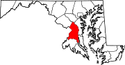
U.S. Routes Interstate Highways Roads by name Categories:- State highways in Maryland
- Roads in Montgomery County, Maryland
- Roads in Prince George's County, Maryland
- Roads in Anne Arundel County, Maryland


Wikimedia Foundation. 2010.