- Maryland Route 208
-
Maryland Route 208
38th Avenue, 38th Street, Hamilton Avenue 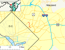
Route information Maintained by MDSHA Length: 1.86 mi[1] (2.99 km) Major junctions South end: 
 US 1 Alt. in Cottage City US 1 in Brentwood
North end:  MD 500 in Hyattsville
Highway system Maryland highway system
Interstate • US • State • Minor • Former • Turnpikes←  MD 202
MD 210  →
→Maryland Route 208 (MD 208) is a state highway in the U.S. state of Maryland. The route runs 1.82 mi (2.93 km) from U.S. Route 1 Alt (Bladensburg Road) in Cottage City north to Maryland Route 500 (Queens Chapel Road) in Hyattsville.
Contents
Route description
Maryland Route 208 begins as 38th Avenue at its intersection with U.S. Route 1 Alt in Cottage City. The road heads north as a two-lane road with a speed limit of 30 mph (48 km/h) through a densely-populated residential area. Shortly after its terminus, MD 208 crosses the railroad tracks of the Capital Subdivision of CSX and MARC Train's Camden Line. The road enters the town of Brentwood on a bridge completed in 1955 and the road's name changes to 38th Street. After passing some commercial establishments, the road arrives at its intersection with U.S. Route 1.
After crossing U.S. 1, MD 208 becomes maintained by the town of Brentwood. The road is a two-lane road with a speed limit of 25 mph (40 km/h) as it passes through residential areas. MD 208 hits its first stop sign at Utah Avenue, which provides access to the Brentwood Volunteer Fire Department and Brentwood Town Hall. The road then encounters stop signs at Volta Avenue and Windom Road. State maintenance resumes and ample signage begins as MD 208 enters the city of Hyattsville by crossing Northwest Branch on a bridge completed in 1932. Soon afterwords, the road reaches the intersection of Hamilton Avenue.
MD 208 turns west onto Hamilton Avenue, which is a two-lane road with a speed limit of 30 mph (48 km/h) through a mix of residences and commercial interests. Soon after, MD 208 reaches its northern terminus at Maryland Route 500 (Queens Chapel Road). Hamilton Avenue continues straight to provide access to Ager Road and the West Hyattsville station of the Washington Metro.
History
Maryland Route 208 was paved in its entirety by 1927, but it did not follow all of the same streets it does today.[2] At its northern end, it continued along Hamilton Street to Ager Road, which was then Maryland Route 209. At its southern end, the route followed its present course, with the exception of the 1955 bridge over the railroad tracks, and was known as Maryland Route 206. In the middle, MD 208 started at what is now U.S. Route 1 in Mount Rainier by heading north on 34th Street for four blocks, east on Varnum Street, north on 37th Street for three blocks, east on Allison Street, then north on its present 38th Street to cross Northwest Branch.[3] By 1946, Taylor Street was used to connect 34th Street and 38th Street in Mount Rainier and Brentwood.[4] MD 208 was assigned to its current routing by 1970.[5]
Junction list
The entire route is in Prince George's County.
Location Mile[1] Destinations Notes Cottage City 0.00
US 1 Alt. (Baltimore Avenue) – Bladensburg, Washington, D.C.Southern terminus Brentwood 0.40 US 1 (Rhode Island Avenue) – Hyattsville, Washington, D.C.0.66 Utah Avenue 0.80 Volta Avenue / Varnum Street 0.97 Windom Road Hyattsville 1.41 Hamilton Street  continues west on Hamilton Street
1.86 MD 500 (Queens Chapel Road) – Hyattsville, Mount Rainier
Hamilton Street
Northern terminus References
- ^ a b Maryland State Highway Administration (2008). "Highway Location Reference: Prince George's County" (PDF). http://apps.roads.maryland.gov/KeepingCurrent/performTrafficStudies/dataAndStats/hwyLocationRef/2008_hlr_all/co16.pdf. Retrieved 2010-01-05.
- ^ Maryland State Highway Administration (1927). "Map of Maryland" (JPG). http://www.mdhighwaycentennial.com/images/template/gallery/maps/1927SIDE1.jpg. Retrieved 2010-01-06.
- ^ Maryland State Highway Administration (1933). "Map of Maryland" (PDF). http://commons.wikimedia.org/wiki/File:Maryland_State_Highway_Map_-_1933.pdf. Retrieved 2010-01-06.
- ^ Maryland State Highway Administration (1946). "Map of Maryland" (PDF). http://commons.wikimedia.org/wiki/File:Maryland_State_Highway_Map_-_1946.pdf. Retrieved 2010-01-06.
- ^ Maryland State Highway Administration (1970). "Map of Maryland" (PDF). http://commons.wikimedia.org/wiki/File:Maryland_State_Highway_Map_-_1970.pdf. Retrieved 2010-01-06.
External links
Roads in Prince George's County, Maryland Maryland State Highways 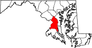
U.S. Routes Interstate Highways Roads by name Categories:- State highways in Maryland


Wikimedia Foundation. 2010.