- Maryland Route 382
-
Maryland Route 382
Croom Road 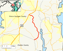
Maryland Route 382 highlighted in redRoute information Maintained by MDSHA Length: 15.34 mi[1] (24.69 km) Major junctions South end: Charles County Line  MD 381
North end:  US 301 in Marlton
Highway system Maryland highway system
Interstate • US • State • Minor • Former • Turnpikes← MD 381MD 383  →
→Maryland Route 382 (MD 382) (Croom Road) is a state highway in Prince George's County. It begins after a small bridge crosses County Line Creek[2] (which links Covington Road in Charles County to Croom Road / Route 382), and it heads north until its northern terminus at US 301 in Marlton.
Route 382 is also a component of the Maryland Scenic Byways system as Byway #13, Star-Spangled Banner[3].
It is a two-lane highway that carries a north–south designation and it runs for a total length of 15.34 miles (24.69 km).
Contents
Route description
Maryland Route 382 begins along Croom Road along County Line Creek as a continuation of Covington Road in Charles County. It travels north through heavily wooded southern Prince George's County and intersects MD 381 in Baden. It continues from there, curving eastward and passing through a mix of woods and farmland, serving mostly homes along its path. After crossing Black Swamp Creek it turns to the north, serving sparse residences and passing by Patuxent River Park, accessible via Mount Calvert Road. The route also passes by the historic Saint Thomas Church, accessible by Saint Thomas Church Road. The route curves to the west and ends at U.S. Route 301.
Notable points of interest on or near Route 382 include:
- Mt. Calvert Historical & Archaeological Park
- Rosaryville State Park (via US 301)
- Merkle Wildlife Sanctuary
Junction list
County Location Mile[1] Intersection Notes Prince George's County 0.00 Charles County Line Southern terminus 0.65 MD 381 - Brandywine Road3.05 Baden Westwood Road 8.30 Candy Hill Road 11.27 St. Thomas Church Road Access to Merkle Wildlife Sanctuary 12.83 Mt. Calvert Road Access to Mt. Calvert Historical & Archaeological Park Marlton 15.34 US 301 (Crain Highway)Northern terminus External links
References
- ^ a b Maryland State Highway Administration (2008). "Highway Location Reference: Prince George's County" (PDF). http://apps.roads.maryland.gov/KeepingCurrent/performTrafficStudies/dataAndStats/hwyLocationRef/2008_hlr_all/co16.pdf. Retrieved 2010-05-19.
- ^ Maryland State Highway Administration, Grid Map of Charles County, Grid H-12, 2004
- ^ Maryland State Highway Administration, Maryland Byways: Star-Spangled Banner, 2008
Roads in Prince George's County, Maryland Maryland State Highways 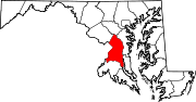
U.S. Routes Interstate Highways Roads by name Accokeek Road • Brandywine Road • Cherry Hill Road • Croom Road • Indian Head Highway • Oxon Hill Road • Piscataway Road • Saint Barnabas Road • Woodyard RoadCategories:- State highways in Maryland
- Roads in Prince George's County, Maryland


Wikimedia Foundation. 2010.