- Croome, Worcestershire
-
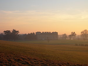
Croome is an 18th century landscape park, garden and mansion house in south Worcestershire designed by Lancelot 'Capability' Brown with some features by Robert Adam. The park and garden are owned by the National Trust. The mansion house, Croome Court, was purchased by the Croome Heritage Trust and is currently leased to the National Trust. Croome is near Pershore, south of Worcester, in Worcestershire, England.
The house and parkland was Lancelot 'Capability' Brown's first landscape design [1] and his first major architectural project [2] and is an important and seminal work.[3] 'Capability' Brown started work at Croome in 1751 for George Coventry, 6th Earl of Coventry. The mansion house was designed by Brown and is a "rare example of his architectural work" and was his "first flight into the realms of architecture".[4] Robert Adam designed parts of Croome Court's interior and along with James Wyatt, designed temples and follies for the park.
The Park and Court are both open to the public for most of the year. It is a pay for entry property, but National Trust members receive free entry.[5] It is now open 7 days a week until the end of October 2011, with the Court being closed on Tuesdays.[6]
Croome Park has a man made lake and river, statues, temples and other buildings with the Court as the central focus. The other buildings around the park include Gatehouses, a Grotto, a Church and buildings termed "eye-catchers". These are Pirton Castle, Panorama Tower, Dunstall Castle and Park Seat. They are set away from the core of the Park and are intended to draw your eye into the wider landscape.
Contents
Features in the Park
The National Trust own and have restored the core of the original 18th century parkland and it is open to visitors throughout the of the year. To visit many of the features below, you have to enter the pay for entry National Trust parkland. Some areas, however, are accessible via public footpaths.
St Mary Magdalene Church: This Grade I listed building was built in 1763 by Capability Brown for the Earl of Coventry. A medieval church was demolished to make way for this church, the interior of which was designed by Robert Adam.
The Rotunda: A domed and circular building close to Croome Court and at the moment inaccessible. The building was purchased together with Croome Court by the Croome Heritage Trust in 2007 and the exterior has been restored in 2010 by the National Trust after being left in a state of neglect for decades. It sits on a ridge to the east of Croome Court in the Home Shrubbery and is shrouded in trees, including 200 year old Cedar of Lebanon. Described as a 'garden room',[7] it was designed by Brown and built between 1754-7. The door and windows are pedimented and inside there's a coffered ceiling and stuccowork by Francesco Vassalli in 1761.[8] The Portland stone panels above the windows and door are Robert Adam's design and were carved by Sefferin Alker and added in 1763.[9] The interior has been made stable by the National Trust and work will be continued to restore its interior completely in the future. It is Grade I listed [10] and the National Trust hopes to open the building to the public in the future once restoration is complete.
The Park Seat: Also known as The Owl's Nest. Built in 1770-2 by Adam. It is situated as a lookout over the park.
The London Arch: The main entrance to the house. This once had railings either side.
Temple Greenhouse: This Grade I listed building was also designed by Robert Adam, completed in 1763. It used to have large sash windows in the front of it, now only the grooves where they used to slide can be seen. It housed the Earl's collection of exotic plants and was heated in the winter by a fire lit in a brick brothy at the back, then the heat was channeled underneath through gaps in the floor.
Around the Lake: The grotto and various features were designed by Capability Brown. 50,000 cubic metres of silt and vegetation were removed when restoring the lake. Nearby are the Punch Bowl gates designed by Wyatt in 1793 to 1794. On one of the islands in the lake is the temple pavilion (1776-7).
Island Pavilion: Grade I listed building
London Lodge: Grade I listed building
The Worcester Lodge: A gate house built in 1801 and subsequently rebuilt in 1879. This sat on the main road to Croome from Worcester. A carriage drive used to run from the lodge directly to the Punch Bowl Gates in the Park itself and onto the Court beyond. The drive way no longer exists and the lodge is now cut off from the rest of the Park by the construction M5 motorway. Today, the lodge is a private residence and not part of the National Trust owned Park. It is a Grade II building.[11] Further down the road on the same side of the M5 is the keeper's house of the menagerie.
Croome Court
Croome Court was designed by Capability Brown and Robert Adam.
The house has been visited by George III, Queen Victoria and George V. During the second world war it housed the Dutch Royal family, who were escaping the Nazi occupation of Holland. In the 1940s the Coventry family had to sell the Court. It was used as a school and also by Hare Krishnas. It lay empty for 12 years until rescue arrived (though at expense of part of the walled garden being built on for garages) and it was patched up and it became a private home once more with its 17 bedrooms.
One room was removed and is displayed in the Metropolitan Museum in New York: The Tapestry Room "George William, sixth earl of Coventry, commissioned this set of tapestries in Paris in 1763 for the tapestry room at his country seat, Croome Court (Worcestershire), which was then being remodeled by Robert Adam"
The kitchen gardens saved in 2000 are now slowly being restored.
In November 2007, Croome Court was bought from the private owner by The Croome Heritage Trust who have leased it to the National Trust for 10 years who will manage it whilst raising funds for its restoration.
The Mansion opened to the public on September 26, 2009 and the National Trust is now trying to raise £4.8 million to secure the long term future of the Court and enter into a 999 year lease from the Croome Heritage Trust.
- Historic house to open to public
- A sneak peek inside the court
- A party and funfare at Croome Court when privately owned
- Croome Court during its use as a school in the 1960s
- The RAF/ TOP SECRET RAF DEFFORD and CROOME COURT
In early 2011 the snowfall across the country caused particular problems for the main building. A build-up of snow on the roof caused water leaks and significant damage to parts of the ceiling in the Long Gallery.
The Eye-catchers
The National Trust own and have restored the eye-catchers of the 18th century parkland. They are not at the core of the parkland and they lie close to public footpaths. At present, the buildings are not open to the public.
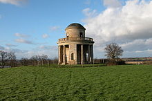
The Panorama Tower:. Another domed and circular folly situated on Knight's Hill at the very edge of the park. This is one of the "eye-catchers" designed to draw the eye into the wider landscape and was acquired by the National Trust in 2009 and has been restored by the charity in 2010. The building had been in deterioration for decades. The building was constructed by James Wyatt using design ideas by Robert Adam.[12] It is a circular 2 storey building with a central interior staircase leading up to a viewing platform under a domed roof where there are views across Worcestershire to the Malverns. The building was not completed until after the 6th Earl of Coventry's death, probably in 1812.[13] The Panorama Tower is a prominent feature from the M5 motorway which cuts through the park and the Tower is now separated from the rest of the park and Court, like the Worcester Lodge. It is a Grade I listed building.[14]
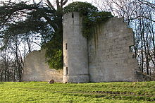
Pirton Castle: A sham castle situated on Rabbit Bank which is a prominent ridge in the landscape at Pirton to the north of the park and Court. This is one of the "eye-catchers" designed to draw the eye into the wider landscape which was acquired by the National Trust in 2009 and has been restored by the charity in the same year.[15] The building had been in deterioration for decades and covered in ivy. The building was designed by James Wyatt and built by William Stephens in 1797 as a ruin.[16] The building was constructed among a row Cedar of Lebanon trees, many of which still stand today along the ridge. It is a Grade I listed building [17] and Pirton Castle is a feature from the M5 motorway northbound which cuts through the park.
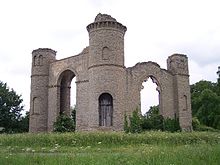
Dunstall Castle: Designed by Robert Adam, this eyecatcher folly, built around 1766, is cut off from the park as it is hidden by trees from within the park. The stones from the tops of the 3 towers have fallen off so that now about a metre is missing from the central tower. The right arch also had a wall at the bottom which has disappeared if compared with original pictures of the castle.
Notes
- ^ Kay, Sarah. Croome Court, Paper prepared for the Arts, Architectural & Learning Panels' Visit. Written for the National Trust, 2008. p. 11. Statement of Significance
- ^ Gordon, Catherine. The Coventrys of Croome. Phillimore & Co. Ltd., 2000. p. 2.
- ^ Gordon, Catherine. The Coventrys of Croome. Phillimore & Co. Ltd., 2000. p. 2.
- ^ Stroud, Dorothy. The Architectural Works of Lancelot Brown. Country Life, January 6, 1940
- ^ [www.nationaltrust.org.uk]
- ^ [www.nationaltrust.org.uk/croomepark]
- ^ Gordon, Catherine. The Coventrys of Croome. Phillimore & Co. Ltd., 2000. p. 117.
- ^ Gordon, Catherine. The Coventrys of Croome. Phillimore & Co. Ltd., 2000. p. 117.
- ^ Garnett, Oliver. Croome Park - Souvenir Guide. National Trust., 2008. p. 18.
- ^ The Rotunda, Listed Buildings Online, English Heritage
- ^ Worcester Lodge, Listed Buildings Online, English Heritage
- ^ Gordon, Catherine. The Coventrys of Croome. Phillimore & Co. Ltd., 2000. p. 122.
- ^ Gordon, Catherine. The Coventrys of Croome. Phillimore & Co. Ltd., 2000. p. 122.
- ^ Panorama Tower, Listed Buildings Online, English Heritage
- ^ http://www.midlandconservation.com/CaseStudies/Pirton_Castle.htm
- ^ Garnett, Oliver. Croome Park - Souvenir Guide. National Trust., 2008. p. 20.
- ^ Pirton Castle, Listed Buildings Online, English Heritage
References
- Mowl, T. (2006). Historic Gardens of Worcestershire
External links
- Croome Park information at the National Trust
- Croome Court walled / kitchen gardens
- CROOME LANDSCAPE PARK PHOTOS Pictures of the whole park
Categories:- National Trust properties in Worcestershire
- Country houses in Worcestershire
- Gardens in Worcestershire
- Grade I listed buildings in Worcestershire
- Grade I listed houses
- Country parks in Worcestershire
- Historic house museums in Worcestershire
- Folly castles in England
Wikimedia Foundation. 2010.


