Croome D'Abitot

Croome D'Abitot

Coordinates: 52°06′08″N 2°10′23″W / 52.102266°N 2.173062°W / 52.102266; -2.173062

Croome D'Abitot
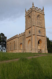
Croome D'Abitot church - geograph.org.uk - 298736.jpg
Croome D'Abitot church
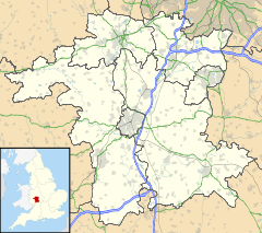
Croome D'Abitot is located in Worcestershire
Croome D'Abitot

 Croome D'Abitot shown within Worcestershire
Parish Croome D'Abitot
District Malvern Hills District
Shire county Worcestershire
Region West Midlands
Country England
Sovereign state United Kingdom
Police West Mercia
Fire Hereford and Worcester
Ambulance West Midlands
EU Parliament West Midlands
UK Parliament West Worcestershire
List of places: UK • England • Worcestershire

Croome D'Abitot is a village and civil parish, which shares a joint parish council with Severn Stoke, in the Malvern Hills District in the county of Worcestershire, England. The parish church of St Mary Magdalene is situated in the grounds of Croome Court.[1]

References

  1. ^ Bridges, Tim Churches of Worcestershire, 2005ed Logaston Press ISBN 1904396399 p74


Wikimedia Foundation. 2010.

Игры ⚽ Нужно решить контрольную?

Look at other dictionaries:

  • St Mary Magdalene's Church, Croome D'Abitot — St Mary Magdalene s Church, Croome D Abitot, from the northwest …   Wikipedia

  • Croome collection — Coordinates: 52°11′10″N 2°10′59″W / 52.186°N 2.183°W / 52.186; 2.183 The Croome collection – the archive of the …   Wikipedia

  • Malvern Hills (district) — Malvern Hills District   Non metropolitan district   Malvern Hills shown within Worcestershire …   Wikipedia

  • Great Malvern — This article relates to the town centre of Malvern. For in depth treatment see Malvern, Worcestershire. Coordinates: 52°07′N 2°20′W / 52.11°N 2.33°W / …   Wikipedia

  • Malvern Wells — Coordinates: 52°04′43″N 2°19′56″W / 52.078479°N 2.332357°W / 52.078479; 2.332357 …   Wikipedia

  • Mamble — Coordinates: 52°20′27″N 2°27′24″W / 52.3407°N 2.4566°W / 52.3407; 2.4566 …   Wikipedia

  • List of civil parishes in Worcestershire — Bromsgrove= Bromsgrove and Rubery are unparished.*Alvechurch *Barnt Green *Belbroughton *Bentley Pauncefoot *Beoley *Bournheath *Catshill and North Marlbrook *Clent *Cofton Hackett *Dodford with Grafton *Finstall *Frankley *Lickey and Blackwell… …   Wikipedia

  • Martley — Coordinates: 52°14′09″N 2°21′37″W / 52.23584°N 2.36018°W / 52.23584; 2.36018 …   Wikipedia

  • Newland, Worcestershire — Coordinates: 52°08′04″N 2°17′59″W / 52.1344°N 2.2997°W / 52.1344; 2.2997 …   Wikipedia

  • Draycott, Worcestershire — Coordinates: 52°07′48″N 2°12′58″W / 52.13011°N 2.21616°W / 52.13011; 2.21616 …   Wikipedia

Share the article and excerpts

Direct link
Do a right-click on the link above
and select “Copy Link”