- Clifton-upon-Teme
-
For other places named "Clifton", see Clifton (disambiguation).
Coordinates: 52°15′11″N 2°25′16″W / 52.253°N 2.421°W
Clifton-upon-Teme 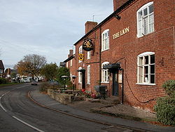
 Clifton-upon-Teme
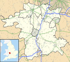
Clifton-upon-Teme shown within WorcestershireDistrict Malvern Hills Shire county Worcestershire Region West Midlands Country England Sovereign state United Kingdom Post town Worcester Postcode district WR6 Police West Mercia Fire Hereford and Worcester Ambulance West Midlands EU Parliament West Midlands List of places: UK • England • Worcestershire Clifton-upon-Teme is a village and civil parish in the Malvern Hills District in the county of Worcestershire, England.
Amenities
Named after the River Teme which runs nearby, it has a village shop, parish church, nursery and primary school, village hall, veterinary surgery, garage and two pubs , the New Inn and the Lion.
History
The village is an excellent example of an Anglo-Saxon settlement overlooking the River Teme, situated on the ancient salt route that led from Droitwich to Leominster.
The earliest surviving mention of the village is in the Latin charter of King Athelstan, granting it to the monks of St. Peter's Monastery in Worcester in 934 AD when it was referred to as Clistun ultra Tame.
During the time of the wars with the Welsh, the manor of Clifton became established and was granted Royal Borough status by Henry III of England in 1270, allowing it to hold a weekly market on Thursdays and an annual four-day fair. The original manor house, built around 1200 on the site of the present Lion Inn, eventually came to be used as a hostelry for travellers en route between Worcester and Tenbury Wells.
External links
- Clifton-upon-Teme village & community website
- British History Online : Clifton-upon-Teme
- photos of Clifton-upon-Teme and surrounding area on geograph
Categories:- Villages in Worcestershire
- Worcestershire geography stubs


Wikimedia Foundation. 2010.