Draycott — may refer to: Draycott, Derbyshire Draycott and Breaston railway station (closed) Draycott, Gloucestershire Draycot, Oxfordshire Draycott, in Rodney Stoke parish, Somerset Draycott Sleights, a nearby SSSI Draycott railway station (closed)… … Wikipedia
Draycott — This interesting name is of Anglo Saxon origin, and is a locational surname deriving from any one of the numerous places in England called Draycott , in Berkshire, Derbyshire, Oxfordshire, Somerset, Staffordshire, Wiltshire, Warwickshire and… … Surnames reference
Kempsey, Worcestershire — Kempsey is a village and civil parish in Worcestershire, England. It is bounded by the River Severn on the west, and the A38 main road runs through it. It is about 3 miles south of Worcester, at gbmapping|SO852490. The Royal Mail postcode begins… … Wikipedia
Newland, Worcestershire — Coordinates: 52°08′04″N 2°17′59″W / 52.1344°N 2.2997°W / 52.1344; 2.2997 … Wikipedia
Oldwood, Worcestershire — Coordinates: 52°17′52″N 2°36′04″W / 52.29779°N 2.60117°W / 52.29779; 2.60117 … Wikipedia
Hallow, Worcestershire — Coordinates: 52°13′16″N 2°15′11″W / 52.221°N 2.253°W / 52.221; 2.253 … Wikipedia
Clifton, Worcestershire — Not to be confused with Clifton upon Teme. Coordinates: 52°06′53″N 2°13′22″W / 52.11486°N 2.222714°W / 52.11486; 2.2 … Wikipedia
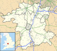
List of places in Worcestershire — This is a list of cities, towns and villages in the ceremonial county of Worcestershire, England. See the list of places in England for places in other counties.compactTOC NOTOC A*Abberton, Abbots Morton, Alfrick, Alvechurch, Areley Kings, Ashton … Wikipedia
Great Malvern — This article relates to the town centre of Malvern. For in depth treatment see Malvern, Worcestershire. Coordinates: 52°07′N 2°20′W / 52.11°N 2.33°W / … Wikipedia
Malvern Hills (district) — Malvern Hills District Non metropolitan district Malvern Hills shown within Worcestershire … Wikipedia
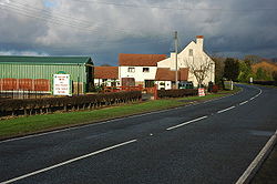
 Draycott
