- Maryland Route 223
-
Maryland Route 223
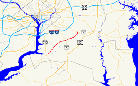
Route information Maintained by MDSHA Length: 12.65 mi[1] (20.36 km) Major junctions South end: Livingston Road in Piscataway  MD 4 in Mellwood
North end: Melwood Road in Mellwood Location Counties: Prince George's Highway system Maryland highway system
Interstate • US • State • Minor • Former • Turnpikes←  MD 222
MD 224  →
→Maryland Route 223 (MD 223) is a state highway in the U.S. state of Maryland. The state highway runs 12.65 miles (20.36 km) from Livingston Road in Piscataway north to Mellwood Road in Mellwood. MD 223 passes through suburban areas of southern Prince George's County, including the community of Woodyard south of Andrews Air Force Base between MD 5 in Clinton and MD 4 in Mellwood.
Contents
Route description
MD 223 begins at an intersection with county-maintained Livingston Road in Piscataway. Livingston Road, which was formerly part of MD 224, heads south toward Accokeek and north toward Fort Washington. The state highway heads northeast as two-lane Floral Park Road. MD 223 turns north onto Piscataway Road at the four-way intersection with that highway; Floral Park Road continues east toward Brandywine. The state highway crosses Piscataway Creek and continues northeast through a mix of forest and residential subdivisions. MD 223 intersects Tippett Road, which heads south toward the historic home Wyoming, next to Washington Executive Airport. The state highway expands to a four-lane undivided highway as it enters Clinton, where the highway passes Surrattsville High School and the Surratt House Museum and intersects the old alignment of MD 5, which heads north as Old Branch Avenue and south as Brandywine Road. MD 223 enters a commercial area and expands to a divided highway around its single-point urban interchange with MD 5 (Branch Avenue).[1][2]
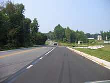 Southbound MD 223 in Mellwood
MD 223 continues east from MD 5 as two-lane Woodyard Road. The state highway intersects Dangerfield Road and Old Alexandria Ferry Road in the hamlet of Coles Corner. MD 223 continues east to the community of Woodyard, where the highway passes the historic home His Lordship's Kindness and cross Piscataway Creek again. MD 223 turns north to continue on Woodyard Road at its intersection with Rosaryville Road, which heads southeast toward the village of Rosaryville and Rosaryville State Park. The state highway gradually curves to the north through the community of Mellwood. MD 223 expands to a four-lane divided highway right before its intersection with the old alignment of MD 4, Marlboro Pike. The state highway, now named Mellwood Road, meets MD 4 (Pennsylvania Avenue) at a partial cloverleaf interchange, then immediately intersects Old Marlboro Pike, which leads east to the historic home Melwood Park. MD 223 reaches its northern terminus immediately to the north when the divided highway rapidly reduces to a very narrow, forest-lined, two-lane county highway.[1][2]
Junction list
The entire route is located in Prince George's County.
Location Mile[1] Intersection Notes Piscataway 0.00 Livingston Road – Accokeek, Fort Washington Southern terminus 0.63 Piscataway Road south / Floral Park Road east – Brandywine MD 223 turns north onto Piscataway Road Clinton 7.45  MD 5 (Branch Avenue) – Waldorf, Washington
Single-point urban interchange Woodyard 10.12 Rosaryville Road south – Rosaryville MD 223 turns north to remain on Woodyard Road Mellwood 12.48 MD 4 (Pennsylvania Avenue) – Upper Marlboro, WashingtonPartial cloverleaf interchange 12.65 Mellwood Road north Northern terminus 1.000 mi = 1.609 km; 1.000 km = 0.621 mi Auxiliary route
MD 223A is the designation for an unnamed 0.10-mile (0.16 km) section of old alignment of MD 223 between the Piscataway Road – Floral Park Road intersection and Piscataway Creek in Piscataway.[1]
References
- ^ a b c d e "Highway Location Reference: Prince George's County" (PDF). Maryland State Highway Administration. 2009. http://www.marylandroads.com/Location/2009_PRINCEGEORGES.pdf. Retrieved 2011-03-07.
- ^ a b Google, Inc. Google Maps – Maryland Route 223 (Map). Cartography by Google, Inc. http://maps.google.com/maps?f=d&source=s_d&saddr=Floral+Park+Rd&daddr=Mellwood+Rd&hl=en&geocode=FVh6TgIdynFp-w%3BFXBKUAIdyb5r-w&mra=ls&sll=38.756935,-76.899745&sspn=0.121012,0.308647&ie=UTF8&t=h&z=12. Retrieved 2011-03-07.
External links
Roads in Prince George's County, Maryland Maryland State Highways 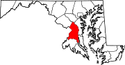
U.S. Routes Interstate Highways Roads by name Accokeek Road • Brandywine Road • Cherry Hill Road • Croom Road • Indian Head Highway • Oxon Hill Road • Piscataway Road • Saint Barnabas Road • Woodyard RoadCategories:- State highways in Maryland
- Roads in Prince George's County, Maryland


Wikimedia Foundation. 2010.