- Maryland Route 43
-
Maryland Route 43
White Marsh Boulevard 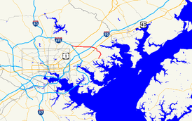
Route information Maintained by MDSHA Length: 8.65 mi[1] (13.92 km) Existed: 1963 – present Major junctions West end:  I-695 near Parkville
 US 1 in Fullerton
 I-95 in White Marsh
 MD 7 near White Marsh
 US 40 near White Marsh
East end:  MD 150 in Middle River
Location Counties: Baltimore Highway system Maryland highway system
Interstate • US • State • Minor • Former • Turnpikes←  MD 42
MD 42MD 44  →
→Maryland Route 43 (MD 43) is a state highway in the U.S. state of Maryland. Known as White Marsh Boulevard, the state highway runs 8.65 miles (13.92 km) from Interstate 695 (I-695) near Parkville east to MD 150 in Middle River. MD 43 is a four-lane divided highway in eastern Baltimore County that connects the northern and eastern suburbs of Baltimore with the commercial center of White Marsh, where the highway has junctions with I-95 and U.S. Route 40 (US 40). The state highway was built from west of I-95 to US 40 concurrent with the construction of I-95 in the early 1960s. MD 43 was extended west to Parkville in the early 1990s and east to Middle River in 2006.
Contents
Route description
MD 43 begins at a partial interchange with I-695 (Baltimore Beltway) near Parkville that includes ramps from eastbound I-695 to eastbound MD 43 and from westbound MD 43 to westbound I-695. The state highway heads east as a four-lane divided controlled-access highway through the forested valley of Whitemarsh Run. As MD 43 passes through the community of Fullerton, the highway has intersections with county-maintained Walther Boulevard and a pair of two-way ramps that connect the boulevard with either direction of US 1 (Belair Road), under which MD 43 passes between the pair of ramps. The state highway continues east into the planned community of White Marsh where the highway has intersections with Perry Hall Boulevard and Honeygo Boulevard, which serve White Marsh Town Center and its centerpiece, White Marsh Mall.[1][2]
East of the town center, MD 43 veers away from Whitemarsh Run and meets I-95 (John F. Kennedy Memorial Highway) at a cloverleaf interchange and has a partial interchange with MD 7 (Philadelphia Road). The state highway continues east across CSX's Philadelphia Subdivision and US 40 (Pulaski Highway). The US 40 interchange includes a two-way ramp between the two highways and a direct ramp from southbound US 40 to westbound MD 43. East of US 40, the state highway crosses over Whitemarsh Run, which heads north to its mouth at the tidal Bird River, itself a tributary of the Gunpowder River. MD 43 curves southeast through a forested area with scattered industrial parks, where the highway crosses over Bird River Road and Windlass Run and intersects Crossroads Circle. The state highway continues southwest into Middle River, crossing over the Amtrak Northeast Corridor before reaching its eastern terminus at MD 150 (Eastern Boulevard) just east of the Martin State Airport station on MARC's Penn Line and Martin State Airport.[1][2]
History
White Marsh Boulevard was constructed concurrent with the portion of I-95 between the boulevard and I-695 in 1962 and 1963.[3][4] The state highway, which was marked as MD 43 by 1965, originally consisted of a four-lane divided section from the Honeygo Boulevard intersection east to US 40, under which the highway passed then followed the present two-way ramp to an intersection with the U.S. Highway. The original highway also had its modern cloverleaf interchange with I-95 and an underpass of MD 7 with no access. At its western end, MD 43 turned north as a two-lane road along what is now Honeygo Boulevard to its western terminus at Silver Spring Road.[5][6] Around 1983, in conjunction with the construction of White Marsh Town Center, the state highway's western terminus was moved to just east of the Honeygo Boulevard intersection, which became a three-way directional intersection with an overpass for traffic from westbound MD 43 south onto Honeygo Boulevard toward White Marsh Mall.[7]
Construction on the western extension of MD 43 from White Marsh Town Center west to I-695 began in 1989 with construction of bridges.[8] The roadways, including the interchange ramps at US 1, were under construction by 1991.[9] MD 43 was rebuilt at Honeygo Boulevard and completed west to I-695 in January 1993.[10][11] Around 1997, the pair of ramps at MD 7 were added.[12] Work on the eastern extension of MD 43 from US 40 east to Middle River began with bridge work in 2004.[13] The state highway was completed east to MD 150 on October 23, 2006, opening up a large area of eastern Baltimore County to commercial and industrial development.[14][15]
Junction list
The entire route is in Baltimore County.
Location Mile
[1]Destinations Notes Parkville 0.00 I-695 west (Baltimore Beltway) – TowsonWestern terminus; I-695 Exit 31C; eastbound exit from and westbound entrance to I-695 Fullerton 1.02 US 1 south (Belair Road) – FullertonTwo-way ramp between MD 43 and southbound US 1 1.69 US 1 north (Belair Road) – Perry HallTwo-way ramp between MD 43 and northbound US 1 White Marsh 4.19 I-95 (John F. Kennedy Memorial Highway) – Baltimore, New YorkI-95 Exit 67 4.76 MD 7 (Philadelphia Road) – Rosedale, JoppaEastbound exit and westbound entrance 5.15 US 40 (Pulaski Highway) – Baltimore, AberdeenTwo-way ramp between MD 43 and US 40 Middle River 8.65 MD 150 (Eastern Boulevard) – Essex, ChaseEastern terminus 1.000 mi = 1.609 km; 1.000 km = 0.621 mi References
- ^ a b c d "Highway Location Reference: Baltimore County" (PDF). Maryland State Highway Administration. 2009. http://www.roads.maryland.gov/Location/2009_BALTIMORE.pdf. Retrieved 2011-06-01.
- ^ a b Google, Inc. Google Maps – Maryland Route 43 (Map). Cartography by Google, Inc. http://maps.google.com/maps?f=d&source=s_d&saddr=Unknown+road&daddr=Whitemarsh+Blvd&hl=en&geocode=FWfvWAIdwF5w-w%3BFZY8WAId2_Fx-w&mra=ls&sll=39.381051,-76.519432&sspn=0.01496,0.038581&ie=UTF8&ll=39.360316,-76.465015&spn=0.059858,0.154324&t=h&z=13. Retrieved 2011-06-01.
- ^ Maryland State Roads Commission. Maryland: Official Highway Map (Map) (1962 ed.).
- ^ Maryland State Roads Commission. Maryland: Official Highway Map (Map) (1963 ed.).
- ^ Maryland State Roads Commission. Maryland: Official Highway Map (Map) (1965 ed.).
- ^ Maryland State Highway Administration. Maryland: Official Highway Map (Map) (1978 ed.).
- ^ Maryland State Highway Administration. Maryland: Official Highway Map (Map) (1983-84 ed.).
- ^ "NBI Structure Number: 100000030347010". National Bridge Inventory. http://nationalbridges.com/. Retrieved 2011-06-01.
- ^ Maryland State Highway Administration. Maryland: Official Highway Map (Map) (1991 ed.).
- ^ Maryland State Highway Administration. Maryland: Official Highway Map (Map) (1993 ed.).
- ^ "Major Transportation Milestones in the Baltimore Region Since 1940" (PDF). Baltimore Metropolitan Council. 2005-12-01. http://www.baltometro.org/reports/MajorTransMilestones.pdf. Retrieved 2010-06-01.
- ^ Maryland State Highway Administration. Maryland: Official Highway Map (Map) (1997 ed.).
- ^ "NBI Structure Number: 100000030371010". National Bridge Inventory. http://nationalbridges.com/. Retrieved 2011-06-01.
- ^ "Highway Location Reference: Baltimore County" (PDF). Maryland State Highway Administration. 2006. http://www.roads.maryland.gov/Location/2006_BALTIMORE.pdf. Retrieved 2011-06-01.
- ^ Sernovitz, Daniel J. (2006-10-23). "Route 43 extension opens". Baltimore Business Journal (Baltimore: American City Business Journals). http://www.bizjournals.com/baltimore/stories/2006/10/23/daily8.html. Retrieved 2011-06-01.
External links
Roads in Baltimore County, Maryland State highways 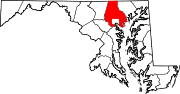
U.S. Highways Interstate Highways Categories:- State highways in Maryland
- Roads in Baltimore County, Maryland


Wikimedia Foundation. 2010.