- Maryland Route 12
-
Maryland Route 12
Snow Hill Road 
Route information Maintained by MDSHA and City of Salisbury Length: 30.63 mi[1][2] (49.29 km) Major junctions South end:  SR 679 at Virginia border south of Stockton
 MD 366 in Stockton
 US 113 in Snow Hill
 US 113 Bus. in Snow Hill
 MD 354 in Indiantown
 US 13 near Salisbury
North end: Main Street in Salisbury Location Counties: Worcester, Wicomico Highway system Maryland highway system
Interstate • US • State • Minor • Former • Turnpikes←  US 11
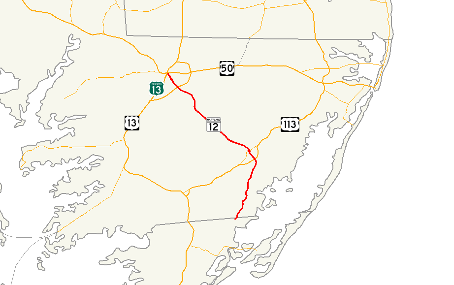
US 11US 13 →Maryland Route 12 is a state highway on the Eastern Shore in the U.S. state of Maryland. The route runs 30.63 mi (49.29 km) from the Virginia border south of Stockton, Worcester County, where it continues into Virginia as State Route 679, north to Main Street in the city of Salisbury in Wicomico County. The route is known as Snow Hill Road for most of its length and passes mostly through areas of woods and farms as well as the communities of Stockton, Girdletree, and Snow Hill. MD 12 intersects several roads including Maryland Route 366 in Stockton, U.S. Route 113 and U.S. Route 113 Business in Snow Hill, Maryland Route 354 in Indiantown, and U.S. Route 13 near Salisbury. Portions of MD 12 near Snow Hill and Stockton existed as unnumbered state roads by 1910. When the first state highways in Maryland were designated by 1927, MD 12 was assigned to run from Stockton north to Salisbury. By 1940, the route was extended south to the Virginia border and a small incomplete portion between Snow Hill and Salisbury was finished. A dumbbell interchange is planned at the US 113 intersection; however, this project is currently on hold.
Contents
Route description
Worcester County
Maryland Route 12 heads north from the Virginia border on Snow Hill Road, which is a two-lane undivided road.[1][3] The road continues south into Virginia as State Route 679 (Fleming Road).[3] From the border, the route passes through a mix of woodland and farmland with a few residences in southern Worcester County before reaching Stockton. Here, MD 12 passes by homes and crosses Maryland Route 366 (George Island Landing Road).[1][3] Upon leaving Stockton, the roads heads back into rural areas and passes near the E.A. Vaughn Wildlife Management Area before reaching the residential community of Girdletree. Past Girdletree, the road continues to the east of a tract of the Pocomoke State Forest as it approaches Snow Hill, the county seat of Worcester County.[3] Just south of Snow Hill, the route intersects U.S. Route 113 (Worcester Highway).[1][3]
Past this intersection, the road enters Snow Hill, where it becomes Church Street, and heads into inhabited areas with some businesses. In the center of town, MD 12 intersects U.S. Route 113 Business (Market Street) and turns east to form a concurrency with that route, passing through the downtown area. Within the downtown, the road passes by the Julia A. Purnell Museum and the Worcester County Courthouse.[4][5] Here, MD 12 turns north to follow Washington Street, crossing the Pocomoke River out of downtown Snow Hill on a drawbridge.[1][3] From here, the route becomes Snow Hill Road again and turns northwest.[3] The road heads into agricultural areas with some residences before Indiantown, where MD 12 intersects the southern terminus of Maryland Route 354 (Whiton Road), which runs north to Willards.[1][3] Past this intersection, the route turns more to the west and heads through a mix of farmland and woodland with occasional homes. The road turns to the northwest again and runs to the northeast of more tracts of the Pocomoke State Forest.[3] The Pocomoke State Forest is known for its loblolly trees and cypress swamps and is popular with fishing and hunting.[6]
Wicomico County
 Northbound MD 12 at intersection with College Avenue/Beaglin Park Drive in Salisbury.
MD 12 crosses into Wicomico County, where it continues north through woods and farms with some residences.[2][3] The route turns northwest again before heading into a mix of residential areas and farm fields on the outskirts of Salisbury.[3] The road comes to a partial cloverleaf interchange with U.S. Route 13 (Salisbury Bypass), where the route briefly becomes a four-lane divided highway . Past US 13, MD 12 crosses into Salisbury at the Johnson Road intersection.[2][3] Here, the route heads north through commercial areas, becoming a six-lane road with a center left-turn lane, two southbound travel lanes and one northbound travel lane. In addition, there is one lane in each direction devoted to right turns. At the intersection with College Avenue/Beaglin Park Drive, the road narrows to four-lane with each direction consisting of one travel lane and a right-turn lane.[3] This configuration eventually ends and MD 12 becomes a two-lane road again, leaving the corporate limits of Salisbury. Upon entering Salisbury again, the route becomes municipally maintained and continues past a mix of residences and businesses with some industrial establishments. MD 12 crosses over a branch of the Wicomico River near the Salisbury city park, which contains the Salisbury Zoo, before ending at Main Street a short distance to the east of U.S. Route 13 Business (Salisbury Boulevard) near downtown Salisbury.[2][3][7]
History
The portion of MD 12 south of Snow Hill was part of an old post road from the 18th century that ran the length of the Delmarva Peninsula.[8] The section of the state highway north of Snow Hill is the descendant of the Old Snow Hill Road from Salisbury whose original bridge across the Pocomoke River dates to 1878.[9] The Maryland State Roads Commission designated the highway from Stockton to Snow Hill as one of the original state roads in 1909. By 1910, the highway was paved within Stockton, between Snow Hill and Indiantown, and for about 2 miles (3.2 km) south from the city limit of Salisbury.[10] The highway was paved from Snow Hill to a point north of Girdletree by 1917.[11] The all-weather road between Snow Hill and Stockton was completed by 1921.[12] The Snow Hill–Salisbury road was under construction by 1923.[13][14] By 1927, MD 12 had been assigned to the highway despite a 4-mile (6.4 km) gap remaining from just north of the Wicomico–Worcester county line south toward Snow Hill.[14][15] That gap was filled by 1930.[16] In addition, MD 12's present northern terminus at Main Street, including the bridge across the South Prong of the Wicomico River, was constructed in 1928 and 1929.[17][18] The highway had previously entered Salisbury along Lincoln Avenue and Division Street.[19] The final portion of MD 12 was completed between Stockton and the Virginia state line by 1933.[20] In addition, the present bridge across the Pocomoke River was completed in 1932.[9][21] MD 12 was widened and straightened from Stockton to Salisbury between 1951 and 1954.[22][23]
Future
An interchange is planned between MD 12 and US 113 south of Snow Hill in order to improve safety and traffic flow as a follow up to widening US 113; however, the project is currently on hold.[24][25] This proposed interchange is to be a dumbbell interchange, a variation of the diamond interchange with two roundabouts on MD 12 where it intersects the ramps to US 113.[25] The proposed cost needed to build this interchange is $24.2 million, which includes engineering, acquisition of land, and the actual construction.[26]
Junction list
County Location Mile[1][2] Intersection Notes Worcester 0.00 SR 679 (Fleming Road/State Line Road)Southern terminus; Virginia state line Stockton 3.31 MD 366 (George Island Landing Road) – Pocomoke City, George Island LandingSnow Hill 11.04 US 113 (Worcester Highway) – Pocomoke City, Berlin12.55 US 113 Bus. south (Market Street) – Pocomoke CitySouth end of US 113 Bus. overlap 12.73 US 113 Bus. north (Market Street) – BerlinNorth end of US 113 Bus. overlap 13.95 MD 354 north (Whiton Road) – WillardsWicomico Salisbury 27.99 US 13 (Salisbury Bypass) – Norfolk, VA, Dover, DEInterchange 30.63 Main Street Northern terminus 1.000 mi = 1.609 km; 1.000 km = 0.621 mi References
- ^ a b c d e f g "Highway Location Reference: Worcester County" (PDF). Maryland State Highway Administration. 2009. http://sha.maryland.gov/Location/2009_WORCESTER.pdf. Retrieved 2010-10-21.
- ^ a b c d e "Highway Location Reference: Wicomico County" (PDF). Maryland State Highway Administration. 2009. http://sha.maryland.gov/Location/2009_WICOMICO.pdf. Retrieved 2010-10-21.
- ^ a b c d e f g h i j k l m n Google, Inc. Google Maps – overview of Maryland Route 12 (Map). Cartography by Google, Inc. http://maps.google.com/maps?f=d&source=s_d&saddr=snow+hill+road+and+stateline+road+stockton,+md&daddr=snow+hill+road+and+main+street+salisbury,+md&hl=en&geocode=&mra=ls&sll=38.015336,-75.423503&sspn=0.015282,0.027595&ie=UTF8&t=h&z=10. Retrieved 2009-08-17.
- ^ "About Us". Julia A. Purnell Museum. http://www.purnellmuseum.com/about.php. Retrieved 2009-09-16.
- ^ "Worcester County, Maryland - Judicial Branch". Maryland State Archives. http://www.msa.md.gov/msa/mdmanual/36loc/wo/html/woj.html. Retrieved 2009-09-16.
- ^ "Pocomoke State Forest". Maryland Department of Natural Resources. http://www.dnr.state.md.us/publiclands/eastern/pocomokeforest.asp. Retrieved 2009-09-16.
- ^ "About Us". Salisbury Zoo. http://www.salisburyzoo.org/ZooFrame.html. Retrieved 2009-09-16.
- ^ "Historic Context for the DuPont Highway U.S. Route 113: Kent and Sussex County, Delaware" (PDF). Delaware Department of Transportation. July 2005. p. 4. http://www.deldot.gov/archaeology/us113_dual/pdf/dert113context_final.pdf. Retrieved 2010-04-26.
- ^ a b Report of the State Roads Commission of Maryland. 1931-1934. Baltimore: Maryland State Roads Commission. 1934-12-28. p. 41. http://www.archive.org/details/reportofstateroa1931mary. Retrieved 2010-04-26.
- ^ Maryland Geological Survey. Map of Maryland (Map) (1910 ed.).
- ^ Report of the State Roads Commission of Maryland. 1916-1919. Baltimore: Maryland State Roads Commission. January 1920. pp. 54–55, 76. http://www.archive.org/details/annualreportsofs1916mary. Retrieved 2010-04-26.
- ^ Maryland Geological Survey. Map of Maryland: Showing State Road System and State Aid Roads (Map) (1921 ed.).
- ^ Maryland Geological Survey. Map of Maryland: Showing State Road System and State Aid Roads (Map) (1923 ed.).
- ^ a b Report of the State Roads Commission of Maryland. 1924-1926. Baltimore: Maryland State Roads Commission. January 1927. pp. 26, 28, 100. http://www.archive.org/details/annualreportsofs1924mary. Retrieved 2010-04-26.
- ^ Maryland Geological Survey. Map of Maryland: Showing State Road System and State Aid Roads (Map) (1927 ed.).
- ^ Maryland Geological Survey. Map of Maryland Showing State Road System: State Aid Roads and Improved County Road Connections (Map) (1930 ed.).
- ^ "NBI Structure Number: 200000WIS-03010". National Bridge Inventory. http://nationalbridges.com/nbi_record.php?StateCode=24&struct=200000WIS-03010. Retrieved 2010-10-22.
- ^ Report of the State Roads Commission of Maryland. 1927-1930. Baltimore: Maryland State Roads Commission. 1930-10-01. pp. 79, 234–235. http://www.archive.org/details/reportofstateroa1927mary. Retrieved 2010-04-26.
- ^ United States Geological Survey. Salisbury, MD Quadrangle (Map). 1:48,000. 15 Minute Series (Topographic) (1901 ed.). http://historical.mytopo.com/quad.cfm?quadname=Salisbury&state=MD&series=15. Retrieved 2010-04-26.
- ^ Maryland Geological Survey. Map of Maryland Showing State Road System: State Aid Roads and Improved County Road Connections (Map) (1933 ed.).
- ^ "NBI Structure Number: 100000230002010". National Bridge Inventory. http://nationalbridges.com/nbi_record.php?StateCode=24&struct=100000230002010. Retrieved 2010-10-22.
- ^ Report of the State Roads Commission of Maryland. 1951-1952. Baltimore: Maryland State Roads Commission. 1952-12-15. pp. 114–115. http://www.archive.org/details/reportofstateroa1951mary. Retrieved 2010-04-26.
- ^ "NBI Structure Number: 100000230001010". National Bridge Inventory. http://nationalbridges.com/nbi_record.php?StateCode=24&struct=100000230001010. Retrieved 2010-10-22.
- ^ "MD 0012 Snow Hill Road grade separation at MD 12 and US 113 – Project Schedule". Maryland State Highway Administration. http://apps.roads.maryland.gov/WebProjectLifeCycle/ProjectSchedule.asp?projectno=WO4112123. Retrieved 2009-08-17.
- ^ a b "US 113/MD 12 Newsletter". Maryland State Highway Administration. Fall 2007. http://apps.roads.maryland.gov/WebProjectLifeCycle/WO411_21/htdocs/Documents/Informational_Public_Workshop/US%20113-MD12%20Public%20Workshop.pdf. Retrieved 2009-08-17.
- ^ "Minutes of the County Commissioners of Worcester County, Maryland". Worcester County, Maryland. October 16, 2007. http://www.co.worcester.md.us/minutes/07%20Minutes/Open%2010-16.pdf. Retrieved 2009-09-18.
External links
Roads in Wicomico County, Maryland State highways 
U.S. Highways Roads in Worcester County, Maryland State highways 
U.S. Highways Categories:- State highways in Maryland
- Roads in Wicomico County, Maryland
- Roads in Worcester County, Maryland


Wikimedia Foundation. 2010.