- Maryland Route 818
-
Maryland Route 818
Main Street 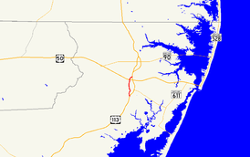
Maryland Route 818 highlighted in redRoute information Maintained by MDSHA Length: 2.62 mi[1] (4.22 km) Major junctions South end:  US 113 in Berlin
 MD 376 in Berlin
 MD 374 in Berlin
 MD 346 in Berlin
 US 50 near Berlin
North end: US 113 near BerlinLocation Counties: Worcester Highway system Maryland highway system
Interstate • US • State • Minor • Former • Turnpikes←  MD 817
MD 819  →
→Maryland Route 818 (MD 818) is a state highway in the U.S. state of Maryland. Known as Main Street, the state highway runs 2.62 miles (4.22 km) between two intersections with U.S. Route 113 (US 113) on the north and south sides of Berlin in Worcester County. MD 818 is the original 1927 alignment of US 113 through Berlin. The state highway was designated shortly after US 113's bypass of Berlin was completed in the late 1950s.
Contents
Route description
MD 818 begins at an intersection with US 113 (Worcester Highway) on the south side of Berlin. Germantown Road continues as a county highway on the east side of the intersection. MD 818 heads north through the town of Berlin as a two-lane road, passing Worcester Preparatory School, Buckingham Elementary School, and the historic home Burley Manor. The state highway enters the Berlin Commercial District, where the highway intersects MD 376 (Bay Street), MD 374 (Broad Street), and unsigned MD 375 (Commerce Street) in rapid succession, with unsigned MD 377 (Williams Street) accessed from MD 376 just to the east. After passing the Calvin B. Taylor House Museum, MD 818 leaves the downtown area. The state highway crosses the Snow Hill Line of the Maryland and Delaware Railroad at a rakish angle before intersecting MD 346 (Old Ocean City Boulevard) and leaving the town of Berlin. MD 818 passes through farmland and intersects US 50 (Ocean Gateway). The state highway continues north, crossing the railroad track again before reaching its northern terminus at US 113. Georgetown Road continues as a county highway on the east side of the intersection.[1][2]
History
Main Street was paved through Berlin by 1910 and designated part of US 113 in 1927.[3][4] US 113's bypass of Berlin was under construction by 1955 and completed in 1957.[5][6]
Junction list
The entire route is in Berlin in Worcester County.
Mile
[1]Destinations Notes 0.00 Germantown Road south – Germantown Southern terminus US 113 (Worcester Highway) – Snow Hill0.80 MD 376 east (Bay Street) – Assateague Island National Seashore0.82 MD 374 west (Broad Street) – Libertytown, Powellville0.87  MD 375 west (Commerce Street)
MD 375 is unsigned and one-way westbound 1.47 MD 346 (Old Ocean City Boulevard)Old alignment of US 50 2.16 US 50 (Ocean Gateway) – Salisbury, Ocean City2.62 US 113 (Worcester Highway) – Selbyville, DENorthern terminus Georgetown Road east 1.000 mi = 1.609 km; 1.000 km = 0.621 mi Auxiliary route
MD 818A is a 0.06-mile (0.097 km) one-way ramp from southbound MD 818 to southbound US 113 at the southern junction with US 113 that follows the federal highway's original alignment.[1][7]
References
- ^ a b c d "Highway Location Reference: Worcester County" (PDF). Maryland State Highway Administration. 2009. http://www.marylandroads.com/Location/2009_WORCESTER.pdf. Retrieved 2010-10-26.
- ^ Google, Inc. Google Maps – Maryland Route 818 (Map). Cartography by Google, Inc. http://maps.google.com/maps?f=d&source=s_d&saddr=S+Main+St&daddr=N+Main+St+to:Main+St%2FMD-818+S&hl=en&geocode=FeifSAId-D6E-w%3BFerLSAIdnz6E-w%3BFR8nSQId_U6E-w&mra=ls&sll=38.34657,-75.214462&sspn=0.007724,0.01929&ie=UTF8&t=h&z=13. Retrieved 2010-04-09.
- ^ Maryland Geological Survey. Map of Maryland (Map) (1910 ed.).
- ^ Maryland Geological Survey. Map of Maryland: Showing State Road System and State Aid Roads (Map) (1927 ed.).
- ^ Report of the State Roads Commission of Maryland. 1955-1956. Baltimore: Maryland State Roads Commission. 1956-11-02. p. 125. http://www.archive.org/details/annualreportsofs1955mary. Retrieved 2010-04-09.
- ^ Maryland State Roads Commission. Maryland: Official Highway Map (Map) (1957 ed.).
- ^ Google, Inc. Google Maps – Maryland Route 818A (Map). Cartography by Google, Inc. http://maps.google.com/maps?f=d&source=s_d&saddr=Unknown+road&daddr=Unknown+road&hl=en&geocode=FTqgSAIdLzyE-w%3BFaicSAIdKD2E-w&mra=ls&sll=38.313097,-75.219904&sspn=0.000966,0.002411&ie=UTF8&ll=38.313585,-75.219795&spn=0.000966,0.002411&t=h&z=19. Retrieved 2010-04-09.
External links
Roads in Worcester County, Maryland State highways 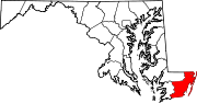
U.S. Highways Categories:- State highways in Maryland
- Roads in Worcester County, Maryland


Wikimedia Foundation. 2010.