- Maryland Route 359
-
This article is about the current Maryland Route 359. For the former highway, see Maryland Route 359 (former).
Maryland Route 359
Bypass Road 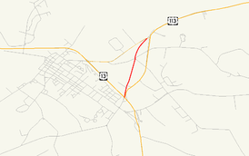
Maryland Route 359 highlighted in redRoute information Maintained by MDSHA Length: 1.09 mi[1] (1.75 km) Major junctions South end: Dead end in Pocomoke City North end:  MD 756 in Pocomoke City
Location Counties: Worcester Highway system Maryland highway system
Interstate • US • State • Minor • Former • Turnpikes←  MD 358
MD 360  →
→Maryland Route 359 (MD 359) is a state highway in the U.S. state of Maryland. Known as Bypass Road, the state highway runs 1.09 miles (1.75 km) from a dead end adjacent to the junction of U.S. Route 13 and US 113 north to MD 756 within Pocomoke City. What is now MD 359 and unsigned MD 250A was part of a bypass of the center of Pocomoke City for the southernmost part of US 113 that was constructed in the mid 1930s. US 113 originally followed MD 756 to its southern terminus at what is now US 13 Business. The bypass was itself bypassed in the 1970s when US 113 was expanded to a four-lane divided highway to end at US 13.
Contents
Route description
MD 359 begins at a dead end adjacent to Worcester Post 93 of the American Legion.[2][3] The state highway heads north as a two-lane road and meets American Legion Drive (unsigned MD 359B), which provides access to US 113.[1][3] MD 359 continues north through a mix of residences and farms, meeting Carter Road, Byrd Road, and Groton Road at a five-way intersection. The state highway reaches its northern terminus at an oblique intersection with MD 756 (Old Snow Hill Road).[3]
History
US 113 presently follows its third alignment in Pocomoke City. The first alignment, to which US 113 was assigned in 1927, began at US 13 (now US 13 Business) within the city limits, following Sixth Street and Linden Avenue to the western end of what is now MD 756. US 113 then followed MD 756 to its present intersection with US 113.[4] The second alignment is followed by present day MD 250A and MD 359 between US 13 (now US 13 Business) and MD 756, and MD 359A north of MD 756. This bypass was completed in 1936.[5][6] The present US 113 four-lane divided highway was constructed in 1974, cutting off the second alignment's direct access to US 13, which had moved to its own four-lane divided bypass of Pocomoke City in 1963.[7][8]
Junction list
The entire route is in Pocomoke City in Worcester County.
Mile
[1]Destinations Notes 0.00 Cul-de-sac at American Legion Southern terminus 0.14 American Legion Drive north to US 113 / US 13 – Salisbury, Norfolk Unsigned MD 359B 1.09  MD 756 (Old Snow Hill Road) to US 113 – Snow Hill
Northern terminus 1.000 mi = 1.609 km; 1.000 km = 0.621 mi Auxiliary routes
MD 359 has two auxiliary routes. Both MD 359A and MD 359B were assigned at the same time as MD 359 shortly after the completion of the present alignment of US 113 in the 1970s.
- MD 359A is the designation for Olds Road, a 0.14-mile (0.23 km) spur from MD 756 north parallel to US 113 that serves a few residences.[1][9] MD 359A is part of the original alignment of US 113.
- MD 359B is the designation for American Legion Drive, a 0.06-mile (0.097 km) connector between MD 359 and US 113 near the former's southern terminus.[1][10]
References
- ^ a b c d e "Highway Location Reference: Worcester County" (PDF). Maryland State Highway Administration. 2009. http://www.marylandroads.com/Location/2009_WORCESTER.pdf. Retrieved 2010-10-24.
- ^ "Worcester County Posts". American Legion Department of Maryland. 2009. http://www.mdlegion.org/WorcesterCounty.htm. Retrieved 2010-04-08.
- ^ a b c Google, Inc. Google Maps – Maryland Route 359 (Map). Cartography by Google, Inc. http://maps.google.com/maps?f=d&source=s_d&saddr=Bypass+Rd&daddr=Bypass+Rd%2FMD-359+N&hl=en&geocode=FdbYRAIdvjp_-w%3BFXoTRQIdpVF_-w&mra=ls&sll=38.080832,-75.543333&sspn=0.003876,0.009645&ie=UTF8&t=h&z=15. Retrieved 2010-04-08.
- ^ Maryland Geological Survey. Map of Maryland: Showing State Road System and State Aid Roads (Map) (1927 ed.).
- ^ Maryland State Roads Commission. Map of Maryland Showing State Road System (Map) (1936 ed.).
- ^ Report of the State Roads Commission of Maryland. 1935-1936. Baltimore: Maryland State Roads Commission. 1936-12-04. p. 63. http://www.archive.org/details/reportofstateroa1935mary. Retrieved 2010-04-08.
- ^ Maryland State Roads Commission. Maryland: Official Highway Map (Map) (1963 ed.).
- ^ Maryland State Highway Administration. Maryland: Official Highway Map (Map) (1974 ed.).
- ^ Google, Inc. Google Maps – Maryland Route 359A (Map). Cartography by Google, Inc. http://maps.google.com/maps?f=d&source=s_d&saddr=Olds+Rd&daddr=Olds+Rd&hl=en&geocode=FVgVRQId1lR_-w%3BFXobRQIdMFp_-w&mra=ls&sll=38.081984,-75.540919&sspn=0.001938,0.004823&ie=UTF8&ll=38.082664,-75.540603&spn=0.001938,0.004823&t=h&z=18. Retrieved 2010-04-08.
- ^ Google, Inc. Google Maps – Maryland Route 359B (Map). Cartography by Google, Inc. http://maps.google.com/maps?f=d&source=s_d&saddr=Ames+Plaza&daddr=Ames+Plaza&hl=en&geocode=FTLhRAIdKj1_-w%3BFYTfRAId2kF_-w&mra=ls&sll=38.068315,-75.54675&sspn=0.000485,0.001206&ie=UTF8&t=h&z=20. Retrieved 2010-04-08.
External links
Roads in Worcester County, Maryland State highways 
U.S. Highways Categories:- State highways in Maryland
- Roads in Worcester County, Maryland


Wikimedia Foundation. 2010.