- Maryland Route 610
-
Maryland Route 610
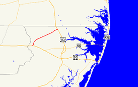
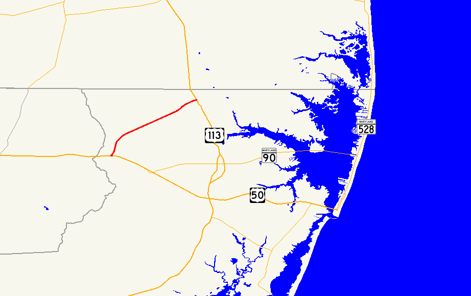
Maryland Route 610 highlighted in redRoute information Maintained by MDSHA Length: 6.53 mi[1] (10.51 km) Major junctions West end: Dale Road near Whaleyville  US 50 in Whaleyville
 MD 346 in Whaleyville
East end:  US 113 near Bishop
Location Counties: Worcester Highway system Maryland highway system
Interstate • US • State • Minor • Former • Turnpikes←  MD 609
MD 611  →
→Maryland Route 610 (MD 610) is a state highway in the U.S. state of Maryland. Known for most of its length as Whaleyville Road, the state highway runs 6.53 miles (10.51 km) from the county-maintained portion of Dale Road near Whaleyville north to U.S. Route 113 (US 113) near Bishop. The first segment of MD 610 was constructed near Whaleyville in the mid 1930s. The highway to Bishop was brought into the state highway system in the 1940s. MD 610, which did not originally reach US 50, was extended south to that highway, now MD 346, in 1955. The state highway reached its current southern terminus after the US 50 divided highway was constructed in the mid 1960s.
Contents
Route description
MD 610 begins at a point on Dale Road 0.20 mi (0.32 km) south of US 50 (Ocean Gateway) near Whaleyville. The state highway heads north from the intersection with US 50 as two-lane Whaleyville Road. After crossing MD 346 (Old Ocean City Boulevard), MD 610 bypasses the center of Whaleyville on the west and intersects Sheppards Crossing Road. The state highway curves to the northeast and crosses Shavox Church Road and Peerless Road as well as Birch Branch on the way to its eastern terminus at US 113 (Worcester Highway) north of Bishop. Hammond Road, which for a short stretch is unsigned MD 575L, continues east on the other side of the intersection toward Bishopville.[1][2]
History
The first segment of MD 610 was constructed from Sheppards Crossing Road to Donaway Road north of Whaleyville in 1935.[3][4] It was connected to US 213 (later US 50 and now MD 346) by Sheppards Crossing Road, which was improved by the Maryland State Roads Commission by 1934.[5] By 1946, state maintenance was extended east to Campbelltown Road near Bishop.[6] The segment between Campbelltown Road and US 113 was brought under state maintenance in 1950.[7] In 1955, MD 610 was extended south along a new alignment from Sheppards Crossing Road to present day MD 346.[8] The state highway was extended south again in 1966 to both connect with the new US 50 divided highway and to access properties on Dale Road, whose original alignment had been interrupted by the relocation of US 50.[9]
Junction list
The entire route is in Worcester County.
Location Mile
[1]Destinations Notes Whaleyville 0.00 Dale Road south Southern terminus 0.20 US 50 (Ocean Gateway) – Ocean City, Salisbury0.73 MD 346 (Old Ocean City Boulevard) – Berlin, WillardsOld alignment of US 50 Bishop 6.53 US 113 (Worcester Highway) – Berlin, Selbyville, DENorthern terminus Hammond Road – Bishopville 1.000 mi = 1.609 km; 1.000 km = 0.621 mi References
- ^ a b c "Highway Location Reference: Worcester County" (PDF). Maryland State Highway Administration. 2009. http://www.marylandroads.com/Location/2009_WORCESTER.pdf. Retrieved 2010-10-26.
- ^ Google, Inc. Google Maps – Maryland Route 610 (Map). Cartography by Google, Inc. http://maps.google.com/maps?f=d&source=s_d&saddr=Dale+Rd&daddr=MD-610+E%2FWhaleyville+Rd&geocode=FZysSQIdDtGC-w%3BFXSPSgIdIiKE-w&hl=en&mra=ls&sll=38.382877,-75.310142&sspn=0.00772,0.01929&ie=UTF8&t=h&z=13. Retrieved 2010-04-07.
- ^ Maryland Geological Survey. Map of Maryland Showing State Road System: State Aid Roads and Improved County Road Connections (Map) (1935 ed.).
- ^ Report of the State Roads Commission of Maryland. 1935-1936. Baltimore: Maryland State Roads Commission. 1936-12-04. p. 258. http://www.archive.org/details/reportofstateroa1935mary. Retrieved 2010-04-07.
- ^ Report of the State Roads Commission of Maryland. 1931-1934. Baltimore: Maryland State Roads Commission. 1934-12-28. p. 112. http://www.archive.org/details/reportofstateroa1931mary. Retrieved 2010-04-07.
- ^ Maryland State Roads Commission. Maryland: Official Highway Map (Map) (1946-47 ed.).
- ^ Maryland State Roads Commission. Maryland: Official Highway Map (Map) (1950 ed.).
- ^ Maryland State Roads Commission. Maryland: Official Highway Map (Map) (1955 ed.).
- ^ Maryland State Roads Commission. Maryland: Official Highway Map (Map) (1966 ed.).
External links
Roads in Worcester County, Maryland State highways 
U.S. Highways Categories:- State highways in Maryland
- Roads in Worcester County, Maryland


Wikimedia Foundation. 2010.