- Maryland Route 707
-
Maryland Route 707
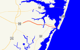
Maryland Route 707 highlighted in redRoute information Maintained by MDSHA MD 707A Length: 0.79 mi[1] (1.27 km) West end:  US 50 in West Ocean City
East end:  MD 611 in West Ocean City
MD 707B Length: 2.20 mi[1] (3.54 km) West end: Dead end in Grays Corner Major
junctions: MD 452 in Grays Corner
 MD 589 in Grays Corner
East end: Grays Corner Road in Grays Corner MD 707D Length: 0.76 mi[1] (1.22 km) West end: Cul-de-sac in in Grays Corner East end: Road end in Grays Corner Location Counties: Worcester Highway system Maryland highway system
Interstate • US • State • Minor • Former • Turnpikes←  MD 704
MD 710  →
→Maryland Route 707 (MD 707) is a collection of state highways in the [[U.S. state of Maryland. These three highways are sections of the old alignment of U.S. Route 213 (now US 50) in northeastern Worcester County. These stretches of highway were bypassed and designated part of MD 707 in the early 1940s in West Ocean City and in the late 1940s in Grays Corner.
Contents
Route description
MD 707A, which is known as Old Bridge Road, runs 0.79 miles (1.27 km) from US 50 to MD 611 within West Ocean City. MD 707B and MD 707D, which are both known as Grays Corner Road, run 2.20 miles (3.54 km) and 0.76 miles (1.22 km), respectively, within Grays Corner.
MD 707A
MD 707A begins at an intersection with US 50 (Ocean Gateway) just east of Herring Creek in West Ocean City. The state highway heads east as a two-lane road. After passing by residential subdivisions, MD 707A reaches its eastern terminus at MD 611 (Stephen Decatur Highway). Old Bridge Road continues east as a county highway to Sinepuxent Bay where the old bridge crossed into Ocean City in line with Worcester Street.[1][2]
MD 707B and MD 707D
MD 707B begins at a dead end near Berlin, adjacent to US 50. The state highway heads east and immediately encounters MD 452. The state highway continues east as a two-lane road paralleling US 50 on the north at a distance, passing farms and residences. After the intersection with MD 589 (Racetrack Road) in Grays Corner, MD 707B parallels US 50 closely until the end of state maintenance just west of Riddle Lane, which is unsigned US 50WA.[1][3]
MD 707D begins at a cul-de-sac adjacent to US 50 a short distance east of the eastern terminus of MD 707B. The state highway heads east as a two-lane road paralleling US 50 on the north from a distance and connects with the federal highway via Herring Creek Lane and an unnamed road, which are designated US 50WB and US 50WC, respectively. MD 707D reaches its eastern terminus at a dead end adjacent to US 50 a short distance west of Herring Creek.[1][4]
History
What is now MD 707 is much of the original alignment of the Berlin–Ocean City road that was paved east to West Ocean City in 1915.[5] The highway was completed when the first automobile bridge across Sinepuxent Bay opened in 1916.[6] The highway was designated the easternmost part of US 213 in 1927.[7] Present day MD 707A was bypassed in 1942 when the present bridge to Ocean City and the dual highway approach west to Herring Creek opened.[8][9] The bypassed portion of US 213 remained a state highway and was designated MD 707 by 1948.[9][10] The segment of MD 707 west of Herring Creek was bypassed in 1950 when the dual highway, which had just been renumbered US 50, was extended to just west of MD 452.[11][12] MD 707A's eastern terminus was rolled back from Sinepuxent Bay to MD 611 in 2001.[13] In 2003, MD 707B was split by construction of an entrance to the Glen Riddle Golf Club subdivision, resulting in the portion east of the split being redesignated MD 707D.[14]
Junction list
All three sections of MD 707 are entirely in Worcester County.
Old Bridge Road
MD 707A is entirely within West Ocean City.
Mile
[1]Destinations Notes 0.00 US 50 (Ocean Gateway) – Salisbury, Ocean CityWestern terminus of MD 707A 0.79 MD 611 (Stephen Decatur Highway) – Assateague Island National SeashoreEastern terminus of MD 707A; Old Bridge Road to the east was formerly part of MD 707A Old Bridge Road east 1.000 mi = 1.609 km; 1.000 km = 0.621 mi Grays Corner Road
MD 707B and MD 707D are entirely within Grays Corner.
Mile
[1]Destinations Notes 0.00 Dead end Western terminus of MD 707B 0.07 MD 452 (Friendship Road) – Friendship1.44 MD 589 (Racetrack Road) – Ocean Pines2.20 Grays Corner Road east to Riddle Lane Eastern terminus of MD 707B; Grays Corner Road to the east was formerly part of MD 707B; Riddle Lane is unsigned US 50WA Break in highway between MD 707B and MD 707D 0.00 Cul-de-sac Western terminus of MD 707D 0.49 Herring Creek Lane Unsigned US 50WB 0.69 To US 50Unsigned US 50WC 0.76 Dead end Eastern terminus of MD 707D 1.000 mi = 1.609 km; 1.000 km = 0.621 mi References
- ^ a b c d e f g h "Highway Location Reference: Worcester County" (PDF). Maryland State Highway Administration. 2009. http://www.marylandroads.com/Location/2009_WORCESTER.pdf. Retrieved 2010-10-26.
- ^ Google, Inc. Google Maps – Maryland Route 707A (Map). Cartography by Google, Inc. http://maps.google.com/maps?f=d&source=s_d&saddr=Old+Bridge+Rd%2FOld+Ocean+City+Rd&daddr=MD-707+E%2FOld+Bridge+Rd&hl=en&geocode=Fe4CSQIdvKmF-w%3BFezrSAIdwNeF-w&mra=ls&sll=38.339401,-75.12625&sspn=0.003863,0.009645&ie=UTF8&t=h&z=16. Retrieved 2010-04-08.
- ^ Google, Inc. Google Maps – Maryland Route 707B (Map). Cartography by Google, Inc. http://maps.google.com/maps?f=d&source=s_d&saddr=Grays+Corner+Rd%2FMD-707+E&daddr=Grays+Corner+Rd%2FMD-707+W+to:Grays+Corner+Rd%2FMD-707+W&hl=en&geocode=FUQRSQIdJqqE-w%3BFTkpSQIdk-uE-w%3BFaMLSQIdBDWF-w&mra=ls&sll=38.348926,-75.17395&sspn=0.007724,0.01929&ie=UTF8&t=h&z=15. Retrieved 2010-04-08.
- ^ Google, Inc. Google Maps – Maryland Route 707D (Map). Cartography by Google, Inc. http://maps.google.com/maps?f=d&source=s_d&saddr=Grays+Corner+Rd%2FMD-707+E&daddr=Grays+Corner+Rd%2FMD-707+E&hl=en&geocode=FUQCSQIdlEqF-w%3BFfL-SAIdGICF-w&mra=ls&sll=38.338315,-75.140669&sspn=0.003863,0.009645&ie=UTF8&t=h&z=16. Retrieved 2010-04-08.
- ^ Report of the State Roads Commission of Maryland. 1912-1915. Baltimore: Maryland State Roads Commission. May 1915. p. 114. http://www.archive.org/details/annualreportsofs1912mary. Retrieved 2010-10-26.
- ^ Reno, Sheri (2007). "Railway Brings Travelers". Ocean City Live-Saving Station Museum. Ocean City Museum Society. http://www.ocmuseum.org/index.php/site/oc-history_article/railway_brings_travelers/. Retrieved 2010-04-08.
- ^ Maryland Geological Survey. Map of Maryland: Showing State Road System and State Aid Roads (Map) (1927 ed.).
- ^ Report of the State Roads Commission of Maryland. 1941-1942. Baltimore: Maryland State Roads Commission. 1943-03-15. p. 78. http://www.archive.org/details/annualreportsofs1941mary. Retrieved 2010-04-08.
- ^ a b Maryland State Roads Commission. Maryland: Official Highway Map (Map) (1946-47 ed.).
- ^ Maryland State Roads Commission. Maryland: Official Highway Map (Map) (1948 ed.).
- ^ Report of the State Roads Commission of Maryland. 1949-1950. Baltimore: Maryland State Roads Commission. 1950-12-20. pp. 98–99. http://www.archive.org/details/annualreportsofs1949mary. Retrieved 2010-04-08.
- ^ Maryland State Roads Commission. Maryland: Official Highway Map (Map) (1950 ed.).
- ^ "Highway Location Reference: Worcester County" (PDF). Maryland State Highway Administration. 2001. http://www.marylandroads.com/Location/2001_WORCESTER.pdf. Retrieved 2010-10-26.
- ^ "Highway Location Reference: Worcester County" (PDF). Maryland State Highway Administration. 2003. http://www.marylandroads.com/Location/2003_WORCESTER.pdf. Retrieved 2010-10-26.
External links
Roads in Worcester County, Maryland State highways 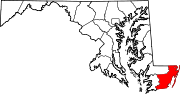
U.S. Highways Categories:- State highways in Maryland
- Roads in Worcester County, Maryland


Wikimedia Foundation. 2010.