- Maryland Route 365
-
Maryland Route 365
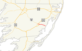
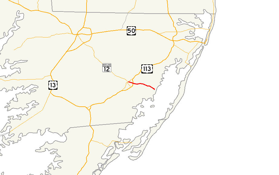
Maryland Route 365 highlighted in redRoute information Maintained by MDSHA Length: 6.29 mi[1] (10.12 km) Major junctions West end:  US 113 Bus. in Snow Hill
 US 113 in Snow Hill
East end: Public Landing Wharf Road in Public Landing Location Counties: Worcester Highway system Maryland highway system
Interstate • US • State • Minor • Former • Turnpikes←  MD 364
MD 366  →
→Maryland Route 365 (MD 365) is a state highway in the U.S. state of Maryland. Known for most of its length as Public Landing Road, the state highway runs 6.29 miles (10.12 km) from U.S. Route 113 Business (US 113 Business) in Snow Hill east to Public Landing Wharf Road in Public Landing. MD 365 was constructed between 1924 and 1929.
Contents
Route description
MD 365 begins at an intersection with US 113 Business (Market Street) just east of downtown Snow Hill. The state highway heads east as two-lane Bay Street. MD 365 crosses the Snow Hill Line of the Maryland and Delaware Railroad at-grade before leaving the town limits of Snow Hill, where the name of the highway changes to Public Landing Road. After passing a recreation center, the state highway intersects US 113 (Worcester Highway) and crosses Pattys Branch. MD 365 passes through the hamlets of Mount Wesley and Spence before entering Public Landing. The state highway reaches its eastern terminus at Public Landing Wharf Road adjacent to the shore of Chincoteague Bay.[1][2]
History
Construction began on MD 365 from Snow Hill in 1924.[3] The highway was completed to Mount Wesley in 1927 and to Public Landing in 1929.[4][5][6]
Junction list
The entire route is in Worcester County.
Location Mile
[1]Destinations Notes Snow Hill 0.00  US 113 Bus. (Market Street) to MD 12 – Salisbury
Western terminus 1.03 US 113 (Worcester Highway) – Pocomoke City, BerlinPublic Landing 6.29 Public Landing Wharf Road north Eastern terminus 1.000 mi = 1.609 km; 1.000 km = 0.621 mi References
- ^ a b c "Highway Location Reference: Worcester County" (PDF). Maryland State Highway Administration. 2009. http://www.marylandroads.com/Location/2009_WORCESTER.pdf. Retrieved 2010-10-24.
- ^ Google, Inc. Google Maps – Maryland Route 365 (Map). Cartography by Google, Inc. http://maps.google.com/maps?f=d&source=s_d&saddr=N+Bay+St&daddr=MD-365+E%2FPublic+Landing+Rd&geocode=FXSORgIdmqKB-w%3BFWAbRgIdMjaD-w&hl=en&mra=ls&sll=38.16369,-75.33865&sspn=0.06195,0.154324&ie=UTF8&t=h&z=13. Retrieved 2010-04-01.
- ^ Report of the State Roads Commission of Maryland. 1924-1926. Baltimore: Maryland State Roads Commission. January 1927. pp. 28, 100. http://www.archive.org/details/annualreportsofs1924mary. Retrieved 2010-04-01.
- ^ Maryland Geological Survey. Map of Maryland: Showing State Road System and State Aid Roads (Map) (1927 ed.).
- ^ Report of the State Roads Commission of Maryland. 1927-1930. Baltimore: Maryland State Roads Commission. 1930-10-01. p. 235. http://www.archive.org/details/reportofstateroa1927mary. Retrieved 2010-04-01.
- ^ Maryland Geological Survey. Map of Maryland Showing State Road System: State Aid Roads and Improved County Road Connections (Map) (1930 ed.).
External links
Roads in Worcester County, Maryland State highways 
U.S. Highways Categories:- State highways in Maryland
- Roads in Worcester County, Maryland


Wikimedia Foundation. 2010.