- U.S. Route 13 in Maryland
-
This article is about the section of U.S. Route 13 in Maryland. For the entire length of the highway, see U.S. Route 13.
U.S. Route 13
Ocean Highway
Salisbury Bypass
N. Salisbury Boulevard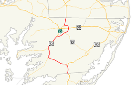
Route information Maintained by MDSHA Length: 42.48 mi[1][2][3] (68.36 km) Existed: 1926 – present Major junctions South end:  US 13 at VA state line near Pocomoke City
 US 113 in Pocomoke City
 MD 413 in Westover
 US 13 Bus. near Fruitland
 MD 12 near Salisbury
 US 50 in Salisbury
US 13 Bus. in Salisbury
 DE/MD 54 in Delmar
North end: US 13 at DE state line in DelmarLocation Counties: Worcester, Somerset, Wicomico Highway system United States Numbered Highways
List • Bannered • Divided • ReplacedMaryland highway system
Interstate • US • State • Minor • Former • Turnpikes← MD 12MD 14  →
→U.S. Route 13 (US 13) is a U.S. Highway running from Fayetteville, North Carolina north to Morrisville, Pennsylvania. In the U.S. state of Maryland, the route runs 42.48 mi (68.36 km) from the Virginia border south of Pocomoke City in Worcester County north to the Delaware border in Delmar, Wicomico County, where the route intersects Delaware/Maryland Route 54, which runs along the state line. The majority of the route within Maryland is a four-lane divided highway that passes through rural areas of woodland and farmland. The route also runs through a few municipalities including Pocomoke City and Princess Anne and it bypasses Salisbury and Fruitland to the east on the Salisbury Bypass, which is a freeway. US 13 intersects many major roads including the southern terminus of U.S. Route 113 in Pocomoke City, Maryland Route 413 in Westover, and Maryland Route 12 and U.S. Route 50 where the route is on the Salisbury Bypass. The route shares a concurrency with US 50 along a portion of the Salisbury Bypass.
US 13 was designated through Maryland when the U.S. Highway System was established in 1926, running along existing roads. It formed a part of the Ocean Highway, a road that connected the New York City area to Florida, and still carries that name for much of its route in Maryland. Many realignments of the route occurred over the years, with one by 1940 that moved the road to a new alignment between Greenhill and Princess Anne and from north of Princess Anne to Salisbury, another by 1960 that bypassed Princess Anne, and one by 1975 that bypassed Pocomoke City. By 1983, US 13 was moved to the limited-access Salisbury Bypass that had opened in stages. Many former alignments of US 13 in Maryland are still part of the state highway system. U.S. Route 13 Business has been designated along former alignments through Pocomoke City and Salisbury (see also US 13 Business Pocomoke City and US 13 Business Salisbury) while the original alignments of the route through Princess Anne and Delmar have been designated Maryland Route 675, and a portion of the former route north of Princess Anne has been designated as Maryland Route 529.
Contents
Route description
Worcester County
Entering the state from Virginia, U.S. Route 13 heads north on Ocean Highway, a four-lane, 55 mph (89 km/h) divided highway that runs a short distance to the east of the Bay Coast Railroad line.[1][4] Upon entering Maryland, US 13 features a welcome center in the northbound direction. It continues north through wooded areas before heading into a mix of farmland and woodland with some residences and businesses along the road. As the road approaches Pocomoke City, more businesses start to line the road. Before entering Pocomoke City, U.S. Route 13 Business heads northwest from US 13 on Market Street into the downtown area.[4] Past this intersection, the road enters Pocomoke City, where the speed limit drops to 50 mph (80 km/h).[1] The route crosses Maryland Route 366 (Stockton Road), which itself has its western terminus at US 13 Business, and continues north past a shopping center, meeting the southern terminus of U.S. Route 113, as well as Maryland Route 250A (Old Virginia Road), along the eastern edge of town. Continuing around the northern edge of the town, the route passes residential areas to the southwest and rural areas to the northeast before heading into a commercial district and intersecting Maryland Route 756 (Old Snow Hill Rd).[1][4] US 13 turns west into wooded areas before crossing the Pocomoke River upstream of US 13 Business.[4]
Somerset County

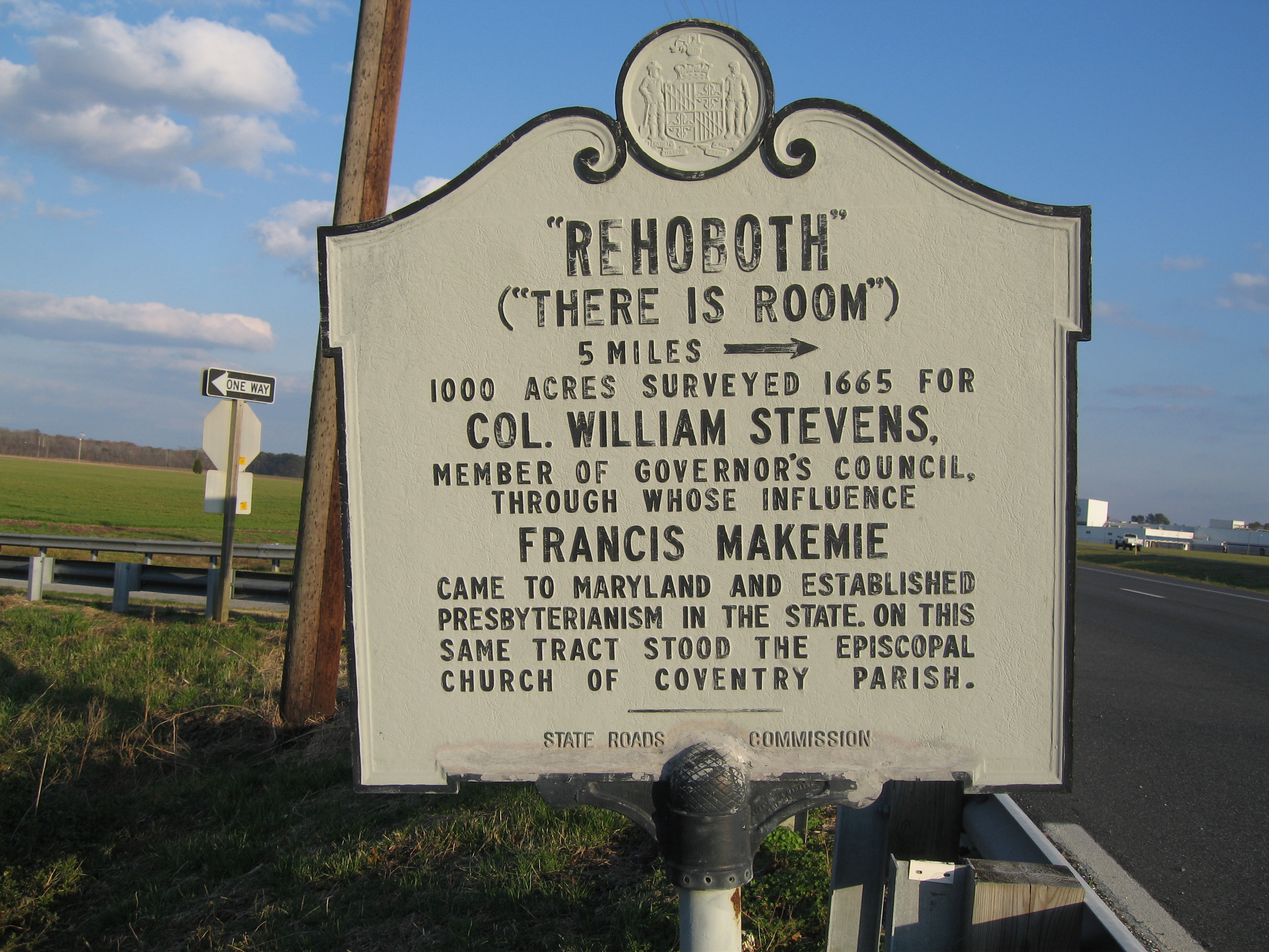
Upon crossing the Pocomoke River, US 13 heads into Somerset County and intersects the northern terminus of US 13 Business and the southern terminus of Maryland Route 364 (Dividing Creek Road). From here, the speed limit increases back to 55 mph (89 km/h) and the route curves to the northwest and runs through rural countryside. It features an intersection with the eastern terminus of Maryland Route 667 (Rehobeth Road), and the route continues from farmland into heavy woodland. US 13 heads back into agricultural areas where it intersects many unsigned suffixed segments of Maryland Route 920 which are mostly short, dead-end roads.[2][4] The route continues west and northwest before it intersects Maryland Route 673 (Sam Barnes Road), which provides a connection to southbound Maryland Route 413 and Crisfield. Past MD 673, US 13 turns north and meets the northern terminus of MD 413 (Crisfield Highway), with access to that route only in the southbound direction.[2][4]
Now running north-northeast, the highway heads through heavy woodland, with trees in the median. US 13 intersects Maryland Route 640 (Revells Neck Road), which heads west to serve the Eastern Correctional Instiution.[4] From here, the road heads north through a mix of woods and farms, running a short distance to the west of a Norfolk Southern rail line.[4] It is eventually paralleled to the west by the main segment of unsigned Maryland Route 920 (Market Lane), which serves as a frontage road.[2][4] Along this stretch, more development starts to line the road as it approaches Princess Anne.[4] After the northern terminus of MD 920, Maryland Route 675 heads north from US 13 into downtown Princess Anne on Somerset Avenue (US 13's original alignment through Princess Anne). The route curves northwest again as it bypasses the town.[2][4]
Skirting the western edge of the town, the route intersects Maryland Route 363 (Deal Island Road/Manokin Avenue) next to Manokin River Park.[2][4] Continuing north, the route soon intersects Maryland Route 362 and passes by some businesses past that intersection.[2][4] The next intersection is for Maryland Route 822 (UMES Boulevard), which heads east to provide access to the University of Maryland Eastern Shore campus. US 13 curves northeast and exits the town, intersecting the northern terminus of MD 675 in the town's outskirts. It continues through wooded areas, again closely paralleling the Norfolk Southern rail line.[4] US 13 intersects the northern terminus of Maryland Route 529, a rural route that heads south back to Princess Anne on Loretto Road. Past MD 529, the road continues northeast, intersecting Peggy Neck Road.[2][4] From here, the highway heads through more woodland before passing through the community of Eden and continuing into open farmland.[4]
Wicomico County
US 13 crosses the Passerdyke Creek into Wicomico County, where it continues northeast as South Fruitland Boulevard through a mix of woods and farms. Shortly after entering Wicomico County, the route diverges from US 13 Business at a semi-directional wye junction. US 13 Business continues towards Fruitland and downtown Salisbury on South Fruitland Boulevard while US 13 turns northeast and upgrades into the Salisbury Bypass, a four-lane, 65 mph (105 km/h) freeway.[3][4]
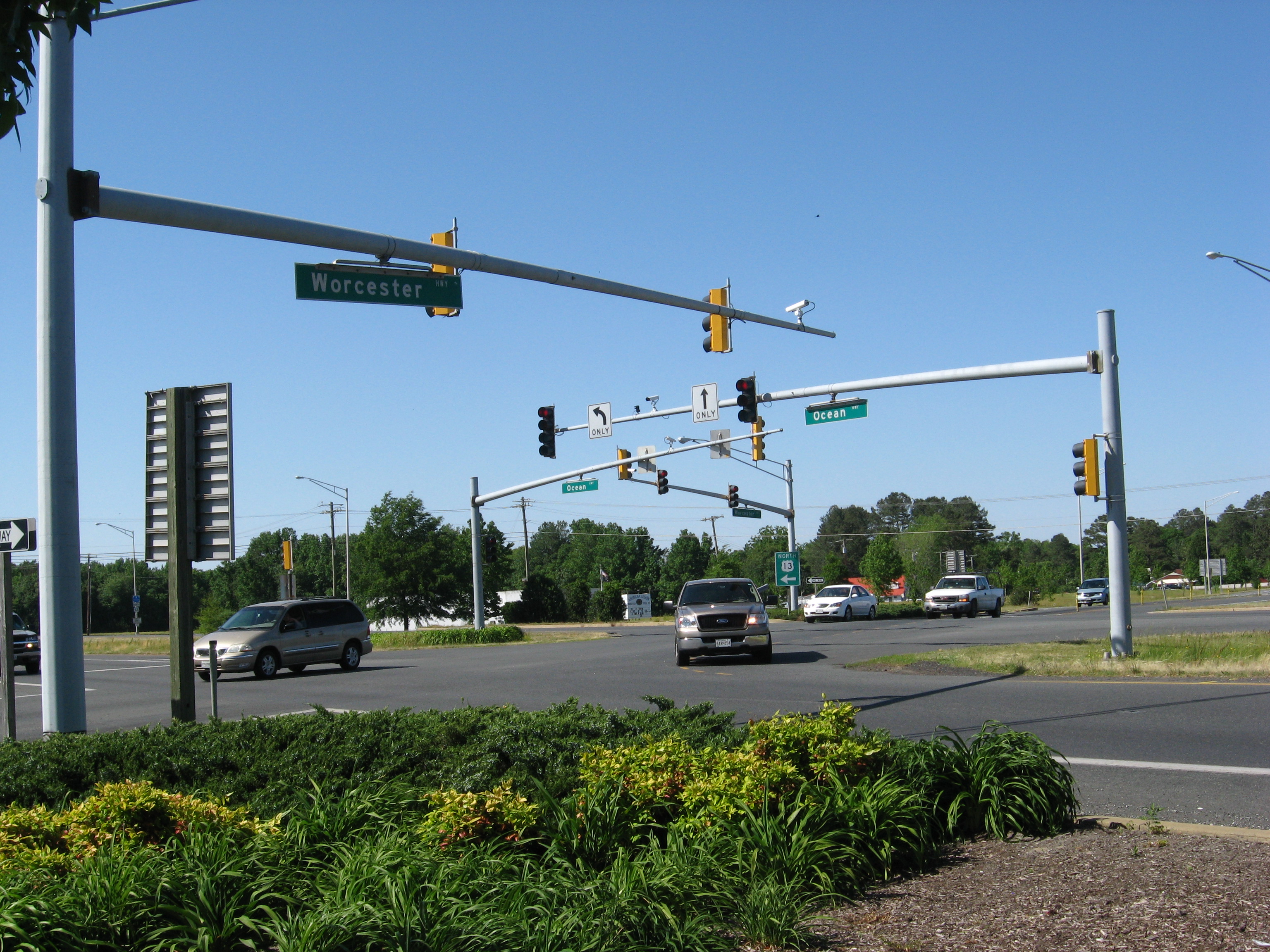
Bypassing the Salisbury area to the east, the route heads through farmland and meets Maryland Route 513 (St. Lukes Road) at a diamond interchange. MD 513 provides access from the US 13 bypass into Fruitland. Continuing northeast through a mix of farmland and woodland, with some housing developments nearby, US 13 meets Maryland Route 12 (Snow Hill Road) at a partial cloverleaf interchange.[3][4] MD 12 serves as a direct link between Salisbury and Snow Hill, connecting with U.S. Route 113 in Snow Hill.[4] Turning north near Parker Pond the highway crosses over Maryland Route 350 (Mt. Hermon Road) with no interchange between the routes, and continues north to another partial interchange with U.S. Route 50 and U.S. Route 50 Business to the east of Salisbury.[4]
The interchange between US 13, US 50, and US 50 Business, modified from a full cloverleaf with the completion of the Salisbury Bypass west of US 13 to US 50, is the site of the eastern terminus of US 50 Business, US 50's original route through Salisbury.[4] US 50 joins US 13 at this interchange, and the two routes run concurrent along 3 miles (5 km) of the Salisbury Bypass.[3][4] Just beyond the interchange, the road passes over Maryland Route 346 (Old Ocean City Road) with no interchange. The Salisbury Bypass turns to the west and meets the northern terminus of US 13 Business (North Salisbury Boulevard) at the original northern terminus of the bypass. US 13 separates from US 50 at this interchange and rejoins its original northward route, while US 50 continues west on the Salisbury Bypass to rejoin its original route northwest of Salisbury.[4]
US 13, now known as North Salisbury Boulevard, continues north into a commercial area on a six-lane, 50 mph (80 km/h) divided highway, immediately passing by The Centre at Salisbury shopping mall. The road passes numerous businesses before crossing Leonard Pond, as the road narrows to five lanes (with two lanes southbound and three lanes northbound), and becomes Ocean Highway again. It passes by a set of weigh stations located on both sides of the road and intersects the southern terminus of a separate Maryland Route 675, which follows US 13's original route through Delmar on Bi State Boulevard.[3][4] US 13 continues north as a four-lane, 55 mph (89 km/h) highway (with two lanes in each direction), through a mix of farms and woods with some businesses, skirting Delmar to the east.[3][4] The route intersects Delaware/Maryland Route 54 (Maryland Delaware Line Road), which runs along the Delaware-Maryland border, and US 13 continues north into Delaware.[4]
History
Ocean Highway

The entire route of US 13 in Maryland is part of the Ocean Highway, an Atlantic coastal highway stretching from Jacksonville, Florida to New Brunswick, New Jersey that served as the quickest route between the New York City area and Florida before the introduction of the Interstate Highway System. US 13 is one of only four U.S. Routes that form the highway and Maryland was one of the states that participated in the highway's formation.[5]
Original 1926 plan
When the U.S. Highway System was started in 1926, US 13 was placed along existing roads in the state. Originally, it entered from Virginia along its current alignment and ran along Market Street (present-day US 13 Business) in Pocomoke City. It crossed the Pocomoke River on a drawbridge and entered Somerset County on a now-severed alignment south of its successor route. The route headed west to Peach Orchard Road and turned north, passing through what is now the parking lot for a Sysco warehouse. It crossed the present-day alignment and followed Costen Road, crossing the current alignment of US 13 again before following Greenhill Lane to an alignment that no longer exists. From there, US 13 followed Old Princess Anne Road north to Princess Anne, where it ran along present MD 675 (Somerset Avenue) in that town. North of Princess Anne, the route followed present MD 529 and crossing the current alignment of US 13 again, following Allen Road before shifting onto Camden Avenue, which the route followed through Fruitland and into Salisbury. Where US 50 Business is today, US 13 moved to Division Street and continued north on its present corridor. Past Leonard Pond, US 13 ran along what is now a dead-end alignment connecting it to present-day MD 675 (Bi State Boulevard) again, following that road to Delmar and the state line.[6]
Major realignments
By 1940, US 13 bypassed Camden Avenue with a new alignment, which is currently Fruitland Boulevard and Salisbury Boulevard. The new alignment continued south to Princess Anne. The Loretto Road and Allen Road portions of the old alignment became MD 529, while the Camden Avenue portion became Maryland Route 663. Also by this time, US 13 was shifted to its current corridor between Greenhill and Princess Anne, with Old Princess Anne Road becoming Maryland Route 598.[7] By 1960, MD 663 was replaced by MD 529, the MD 529 designation was removed from Allen Road, and MD 598 was removed from the state highway system.[8] The MD 529 designation was removed from Camden Avenue by the 1990s.[9]
A bypass of Princess Anne was completed by 1960, with the old alignment of US 13 through the town becoming MD 675. The route was also dualized north of the town and north of Salisbury, where a new alignment bypassed Delmar to the east. The former alignment was designated as U.S. Route 13 Alternate, eventually becoming MD 675. Between MD 413 and the Worcester County line, the road was moved onto its present corridor, and south of Pocomoke City it was dualized.[8] US 13 would be completely dualized within Maryland by 1975. Also by this time, a bypass of Pocomoke City was built for US 13, with the former route (Market Street) designated as MD 675 before later becoming U.S. Route 13 Business.[10]
Salisbury Bypass
Eventually, construction started on a limited-access bypass to the east of Salisbury for US 13. By 1975, the first segment of the new Salisbury Bypass was opened, from a partial interchange with US 13's original route north of Salisbury to Maryland Route 12 southeast of the city.[10] By 1981, the bypass was completed south to MD 513 near Fruitland.[11] The entire length of the Salisbury Bypass was finished by 1983, and the US 13 designation was moved to the bypass, with the route through Salisbury designated as U.S. Route 13 Business.[12]
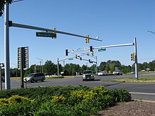
After the extension of the bypass west to US 50 opened on October 19, 2002, the two routes are now cosigned for three miles (5 km) along the Salisbury Bypass.[13] This concurrent section features separate mile markers for both US 13 and US 50, with shields on the mile markers to differentiate between the two routes.[14]
Junction list
County Location Mile
[1][2][3]Destinations Notes Worcester 0.00 Virginia state line Pocomoke City 3.91 US 13 Bus. north (Market Street) – Pocomoke CityFormer US 13 4.23  MD 366 (Stockton Road) – Stockton
4.55 US 113 north (Worcester Highway) / Old Virginia Road (MD 250A) – Snow Hill, Ocean City, Pocomoke City5.44  MD 756 (Old Snow Hill Road)
Former US 113 Somerset West Pocomoke 6.57  US 13 Bus. south (Market Street) / MD 364 north (Dividing Creek Road) – Pocomoke City, Pocomoke River State Park
Former US 13 Costen 8.41  MD 667 south (Rehobeth Road) – Rehobeth, Crisfield
Westover 14.18  MD 673 west (Sam Barnes Road) to MD 413 – Westover, Crisfield
Northbound access to MD 413 14.77 MD 413 south (Crisfield Highway) – CrisfieldNorthbound exit and southbound entrance only 16.04  MD 640 west (Revells Neck Road)
Leads to Eastern Correctional Institute King's Creek 17.12  MD 920 north (Market Lane)
Frontage road 18.08 MD 920 south (Market Lane)Princess Anne 18.18  MD 675 north (Somerset Avenue) – Princess Anne
Former US 13 19.73  MD 363 (Deal Island Road) – Deal Island, Princess Anne
20.45  MD 362 (Mount Vernon Road) – Mount Vernon, Princess Anne
20.88  MD 822 east (UMES Boulevard)
Provides access to University of Maryland Eastern Shore 21.73 MD 675 south (Somerset Avenue)Former US 13, northbound exit and entrance 23.23  MD 529 south (Loretto Road)
Former US 13 Wicomico Fruitland 27.42 US 13 Bus. north (Fruitland Boulevard) – Fruitland, SalisburyNorthbound entrance, southbound exit;
Former US 13South end of expressway section 29.32  MD 513 (Cedar Lane) / St. Lukes Road – Fruitland
31.94 MD 12 (Snow Hill Road) – Salisbury, Snow HillSalisbury 35.33  US 50 east (Ocean Gateway) / US 50 Bus. west (Salisbury Parkway) – Ocean City, Salisbury
South end of US 50 overlap, US 13 northbound has access to Hobbs Road 38.42 US 50 west (Salisbury Bypass) / US 13 Bus. south (Salisbury Boulevard) – Cambridge, Bay Bridge, SalisburyNorth end of US 50 overlap
Former US 13North end of expressway section 40.60 MD 675 north (Bi State Boulevard)Former US 13 Delmar 42.48 DE/MD 54 (Maryland Delaware Line Road)Road forms boundary between states Delaware state line References
- ^ a b c d e "Highway Location Reference: Worcester County" (PDF). Maryland State Highway Administration. 2009. http://sha.maryland.gov/Location/2009_WORCESTER.pdf. Retrieved 2010-10-21.
- ^ a b c d e f g h i "Highway Location Reference: Somerset County" (PDF). Maryland State Highway Administration. 2009. http://sha.maryland.gov/Location/2009_SOMERSET.pdf. Retrieved 2010-10-21.
- ^ a b c d e f g "Highway Location Reference: Wicomico County" (PDF). Maryland State Highway Administration. 2009. http://sha.maryland.gov/Location/2009_WICOMICO.pdf. Retrieved 2010-10-21.
- ^ a b c d e f g h i j k l m n o p q r s t u v w x y z Google, Inc. Google Maps – overview of U.S. Route 13 in Maryland (Map). Cartography by Google, Inc. http://maps.google.com/maps?f=d&source=s_d&saddr=US+13+%40+38.002,+-75.542&daddr=U.S.+13+%26+Maryland+Delaware+Line+Rd&hl=en&geocode=FVDdQwIdEFJ_-w%3BFdjISgIdEhJ_-ylBcI21G_24iTHRKbPsH2ZeoA&mra=pe&mrcr=0&sll=38.252201,-75.565338&sspn=0.492841,0.883026&ie=UTF8&ll=38.228472,-75.618896&spn=0.493002,0.883026&t=h&z=10. Retrieved 2009-04-08.
- ^ Federal Writers' Project (1938). The ocean highway: New Brunswick, New Jersey to Jacksonville, Florida. American Guide Series. New York: Modern Age Books. http://www.archive.org/stream/oceanhighwaynewb00federich/oceanhighwaynewb00federich_djvu.txt. Retrieved 2009-04-10.
- ^ Maryland State Highway Administration (1927). Map of Maryland (Map). http://www.mdhighwaycentennial.com/images/template/gallery/maps/1927SIDE1.jpg. Retrieved 2009-03-03.
- ^ Maryland State Highway Administration (1940). Map of Maryland (Map). http://www.mdhighwaycentennial.com/images/template/gallery/maps/1940SIDE1.jpg. Retrieved 2009-03-03.
- ^ a b Maryland State Highway Administration (1960). Map of Maryland (Map). http://www.mdhighwaycentennial.com/images/template/gallery/maps/1960SIDE1.jpg. Retrieved 2009-03-03.
- ^ Rand McNally (1996). United States-Canada-Mexico Road Atlas (Map).
- ^ a b Exxon (1975). Delaware, Maryland, Virginia, West Virginia (Map). Cartography by General Drafting.
- ^ Exxon (1981). Delaware, Maryland, Virginia, West Virginia (Map). Cartography by General Drafting.
- ^ State Farm Insurance (1983). State Farm Road Atlas (Map). Cartography by Rand McNally.
- ^ "Media Advisory - Lt. Governor Townsend joins the Eastern Shore community to celebrate completion of the new Salisbury Bypass". Maryland State Highway Administration. October 17, 2002. http://www.marylandroads.com/information/newsrel/oc/newstxt.asp?filename=02_10_17.07.z. Retrieved 2009-04-13.[dead link]
- ^ Google Street View (2009). US 13 mile marker 37 (Map). http://maps.google.com/maps?f=d&source=s_d&saddr=US+13+%40+38.002,+-75.542&daddr=U.S.+13+%26+Maryland+Delaware+Line+Rd&hl=en&geocode=FVDdQwIdEFJ_-w%3BFdjISgIdEhJ_-ylBcI21G_24iTHRKbPsH2ZeoA&mra=pe&mrcr=0&sll=38.252201,-75.565338&sspn=0.492841,0.883026&ie=UTF8&ll=38.391825,-75.548258&spn=0,359.972405&t=h&z=15&layer=c&cbll=38.391831,-75.548274&panoid=zxqm1YpfkkO25mOOQetGJw&cbp=12,163.13,,1,0.87. Retrieved 2009-11-13.
External links
U.S. Route 13Previous state:
VirginiaMaryland Next state:
DelawareRoads in Somerset County, Maryland State highways 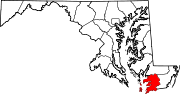
U.S. Highways 13 • 13 BusRoads in Wicomico County, Maryland State highways 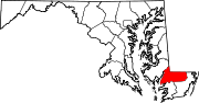
U.S. Highways Roads in Worcester County, Maryland State highways 
U.S. Highways Categories:- U.S. Highways in Maryland
- U.S. Route 13
- Roads in Worcester County, Maryland
- Roads in Somerset County, Maryland
- Roads in Wicomico County, Maryland
- Salisbury, Maryland


Wikimedia Foundation. 2010.