- Maryland Route 349
-
Maryland Route 349
Nanticoke Road 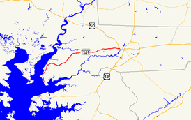
Maryland Route 349 highlighted in redRoute information Maintained by MDSHA and City of Salisbury Length: 22.32 mi[1] (35.92 km) Major junctions West end: Dead end in Nanticoke  MD 352 near Bivalve
 MD 347 in Quantico MD 352 in Catchpenny
East end:  US 50 Bus. in Salisbury
Location Counties: Wicomico Highway system Maryland highway system
Interstate • US • State • Minor • Former • Turnpikes←  MD 348
MD 350  →
→Maryland Route 349 (MD 349) is a state highway in the U.S. state of Maryland. Known as Nanticoke Road, the state highway runs 22.32 miles (35.92 km) from a dead end in Nanticoke east to U.S. Route 50 Business (US 50 Business) in Salisbury. The first segment of MD 349 was constructed by 1910 west of Salisbury. The modern highway reached Catchpenny by 1919, Bivalve by 1925, and its western terminus by 1933. The only major change to MD 349 since is a realignment near Salisbury in the mid 1950s.
Contents
Route description
MD 349 begins at a dead end at Jones Creek near the confluence of the Nanticoke River and Wicomico River as the two rivers enter Tangier Sound.[2] The state highway heads north as a two-lane road through the village of Nanticoke.[1] North of Jesterville Road, MD 349 crosses Windsor Creek and Dunn Creek.[1][2] The state highway continues through the hamlet of Bivalve, where the highway negotiates two sharp curves.[2] MD 349 curves to the east as it leaves Bivalve, intersecting Tyaskin Road, which was formerly MD 541. The state highway passes the west end of MD 352 (Capitola Road), then turns northeast past the Chesapeake Forest Lands and traverses Wetipquin Creek.[1][2]
At the hamlet of Royal Oak, MD 349 turns east toward its intersections with MD 347 (Quantico Road) in Quantico and with the other end of MD 352 (Whitehaven Road) in Catchpenny, which heads south to the Whitehaven Ferry, a cable ferry that crosses the Wicomico River. After passing North Upper Ferry Road, which heads toward the Upper Ferry cable ferry crossing of the Wicomico River, the state highway begins to pass residential subdivisions and crosses Rockawalking Creek. Just west of Salisbury, the old alignment of MD 349, MD 815 (Old Quantico Road), splits to the east when MD 349 veers southeast.[2] The state highway expands to a four-lane undivided highway before intersecting Parsons Road and the other end of MD 815.[1] Upon crossing Mitchell Pond, MD 349 enters the city of Salisbury and municipal maintenance begins. Main Street splits to the southeast from the eastbound direction of MD 349 immediately before the state highway reaches its eastern terminus at US 50 Business (Salisbury Parkway).[1][2] The highway continues on the opposite side of the intersection as Isabella Street.[1]
History
MD 349 was paved from Salisbury west to Rockawalking Creek by 1910.[3] The improved highway extended west to Catchpenny in 1919 and to Royal Oak in 1921.[4][5] MD 349 was complete to Wetipquin Creek in 1923 and to Bivalve in 1925.[6][7][8] The highway was complete to its western terminus in Nanticoke in 1933.[9][10] Beyond the widening of the road from Salisbury to Tyaskin Road in 1950, the only significant change in MD 349 is the realignment of the highway just west of Salisbury in 1956, with MD 815 assigned to the old alignment.[11][12]
Junction list
The entire route is in Wicomico County.
Location Mile
[1]Destinations Notes Nanticoke 0.00 Dead end Western terminus Bivalve 6.04 Tyaskin Road north – Tyaskin Former MD 541 7.58 MD 352 east (Capitola Road) – WhitehavenQuantico 15.14 MD 347 north (Quantico Road) – HebronCatchpenny 15.77 MD 352 west (Whitehaven Road) – Whitehaven17.46 North Upper Ferry Road south – Upper Ferry Salisbury 21.45  MD 815 east (Old Quantico Road)
Old alignment of MD 349 22.15 MD 815 west (Old Quantico Road)22.29 Main Street east Old alignment of US 50 22.32 US 50 Bus. (Salisbury Parkway) – Cambridge, Ocean CityEastern terminus Isabella Street east 1.000 mi = 1.609 km; 1.000 km = 0.621 mi References
- ^ a b c d e f g h "Highway Location Reference: Wicomico County" (PDF). Maryland State Highway Administration. 2009. http://www.marylandroads.com/Location/2009_WICOMICO.pdf. Retrieved 2010-10-20.
- ^ a b c d e f Google, Inc. Google Maps – Maryland Route 349 (Map). Cartography by Google, Inc. http://maps.google.com/maps?f=d&source=s_d&saddr=MD-349+N%2FNanticoke+Rd&daddr=Nanticoke+Rd&hl=en&geocode=FWaCRwIdkNJ5-w%3BFfB4SQId1jd--w&mra=ls&sll=38.367082,-75.612266&sspn=0.007722,0.01929&ie=UTF8&t=h&z=11. Retrieved 2010-04-22.
- ^ Maryland Geological Survey. Map of Maryland (Map) (1910 ed.).
- ^ Report of the State Roads Commission of Maryland. 1916-1919. Baltimore: Maryland State Roads Commission. January 1920. p. 53. http://www.archive.org/details/annualreportsofs1916mary. Retrieved 2010-04-22.
- ^ Maryland Geological Survey. Map of Maryland: Showing State Road System and State Aid Roads (Map) (1921 ed.).
- ^ Maryland Geological Survey. Map of Maryland: Showing State Road System and State Aid Roads (Map) (1923 ed.).
- ^ Report of the State Roads Commission of Maryland. 1924-1926. Baltimore: Maryland State Roads Commission. January 1927. p. 100. http://www.archive.org/details/annualreportsofs1924mary. Retrieved 2010-04-22.
- ^ Maryland Geological Survey. Map of Maryland: Showing State Road System and State Aid Roads (Map) (1927 ed.).
- ^ Report of the State Roads Commission of Maryland. 1931-1934. Baltimore: Maryland State Roads Commission. 1934-12-28. p. 360. http://www.archive.org/details/reportofstateroa1931mary. Retrieved 2010-04-22.
- ^ Maryland Geological Survey. Map of Maryland Showing State Road System: State Aid Roads and Improved County Road Connections (Map) (1933 ed.).
- ^ Report of the State Roads Commission of Maryland. 1955-1956. Baltimore: Maryland State Roads Commission. 1956-11-02. p. 130. http://www.archive.org/details/reportofstateroa1955mary. Retrieved 2010-04-22.
- ^ Maryland State Roads Commission. Maryland: Official Highway Map (Map) (1956 ed.).
External links
Roads in Wicomico County, Maryland State highways 
U.S. Highways Categories:- State highways in Maryland
- Roads in Wicomico County, Maryland


Wikimedia Foundation. 2010.