- Maryland Route 352
-
Maryland Route 352
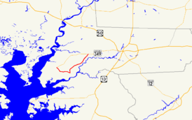
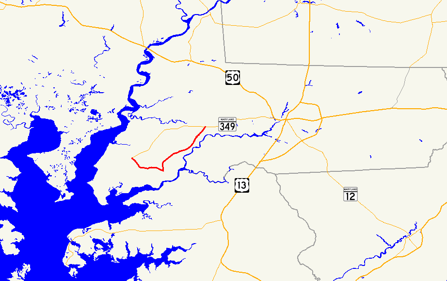
Maryland Route 352 highlighted in redRoute information Maintained by MDSHA Length: 10.03 mi[1] (16.14 km) Major junctions West end:  MD 349 near Bivalve
East end: MD 349 in CatchpennyLocation Counties: Wicomico Highway system Maryland highway system
Interstate • US • State • Minor • Former • Turnpikes←  MD 351
MD 353  →
→Maryland Route 352 (MD 352) is an east–west state highway in the U.S. state of Maryland. The state highway runs 10.03 miles (16.14 km) between intersections with MD 349 near Bivalve on the west and Catchpenny on the east. The Whitehaven Road portion of MD 352 was constructed as a state highway from Catchpenny west to Green Hill Creek in the early 1930s. The state highway was extended south to Whitehaven, the north landing of the Whitehaven Ferry, by 1946. The Capitola Road portion of MD 352 was originally designated MD 385 in the late 1940s and absorbed into MD 352 in the 1960s.
Contents
Route description
MD 352 begins at an intersection with MD 349 (Nanticoke Road) known as Cox's Corner near Bivalve. The state highway heads southeast as two-lane Capitola Road. MD 352 passes by the historic Yellow Brick House and farmland before veering east at Trinity Church Road, which leads to Ellis Bay Wildlife Management Area. The state highway continues east until a perpendicular intersection with Whitehaven Road. Whitehaven Road south leads to Whitehaven, which features the Whitehaven Historic District, including the Whitehaven Hotel, and the Whitehaven Ferry, a cable ferry across the Wicomico River to Mount Vernon in Somerset County. MD 352 turns north onto Whitehaven Road and passes St. Bartholomew's Episcopal Church. The state highway curves northeast through the Chesapeake Forest Lands, then goes by an area of intensive agriculture as the highway crosses Green Hill Creek. MD 352 passes the Green Hill Yacht and Country Club shortly before reaching its eastern terminus at MD 349 in Catchpenny.[1][2]
History
The first portion of MD 352 was constructed between 1930 and 1933 between Catchpenny and Green Hill Creek.[3][4] The portion of Whitehaven Road south of Green Hill was maintained as a county highway until the MD 352 designation was extended to Whitehaven by 1946.[5][6] The Capitola Road segment was designated MD 385 in 1949.[7] The segment of Whitehaven Road south of Capitola Road was returned to county maintenance and MD 352 assumed its present course, taking over the course of MD 385, in 1964.[8]
Junction list
The entire route is in Wicomico County.
Location Mile
[1]Destinations Notes Bivalve 0.00 MD 349 (Nanticoke Road) – NanticokeWestern terminus Whitehaven 3.44 Whitehaven Road south – Whitehaven Ferry MD 352 turns north onto Whitehaven Road; Whitehaven Road south is old alignment of MD 352 Catchpenny 10.03 MD 349 (Nanticoke Road) – Salisbury, QuanticoEastern terminus 1.000 mi = 1.609 km; 1.000 km = 0.621 mi References
- ^ a b c "Highway Location Reference: Wicomico County" (PDF). Maryland State Highway Administration. 2009. http://www.marylandroads.com/Location/2009_WICOMICO.pdf. Retrieved 2010-10-21.
- ^ Google, Inc. Google Maps – Maryland Route 352 (Map). Cartography by Google, Inc. http://maps.google.com/maps?f=d&source=s_d&saddr=Capitola+Rd%2FMD-352+E&daddr=MD-352+E%2FWhitehaven+Rd+to:MD-352+E%2FWhitehaven+Rd&hl=en&geocode=FYZ6SAIdDq56-w%3BFepdSAIdx3F7-w%3BFdxBSQIdxoB8-w&mra=ls&sll=38.355001,-75.724962&sspn=0.007723,0.01929&ie=UTF8&t=h&z=12. Retrieved 2010-04-22.
- ^ Report of the State Roads Commission of Maryland. 1927-1930. Baltimore: Maryland State Roads Commission. 1930-10-01. p. 234. http://www.archive.org/details/reportofstateroa1927mary. Retrieved 2010-04-22.
- ^ Maryland Geological Survey. Map of Maryland Showing State Road System: State Aid Roads and Improved County Road Connections (Map) (1933 ed.).
- ^ Report of the State Roads Commission of Maryland. 1931-1934. Baltimore: Maryland State Roads Commission. 1934-12-28. p. 62. http://www.archive.org/details/reportofstateroa1931mary. Retrieved 2010-04-22.
- ^ Maryland State Roads Commission. Maryland: Official Highway Map (Map) (1946-47 ed.).
- ^ Maryland State Roads Commission. Maryland: Official Highway Map (Map) (1949 ed.).
- ^ Maryland State Roads Commission. Maryland: Official Highway Map (Map) (1964 ed.).
External links
Roads in Wicomico County, Maryland State highways 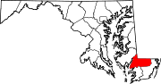
U.S. Highways Categories:- State highways in Maryland
- Roads in Wicomico County, Maryland


Wikimedia Foundation. 2010.